

Chrisrotary12
-
Posts
5,420 -
Joined
-
Last visited
Content Type
Profiles
Blogs
Forums
American Weather
Media Demo
Store
Gallery
Posts posted by Chrisrotary12
-
-
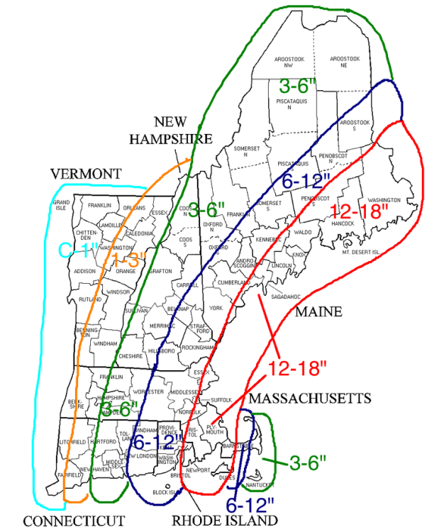
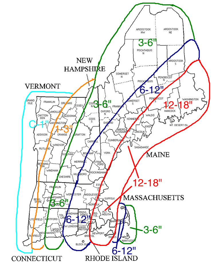
Here is the map that I ran with for my blog yesterday afternoon.
-
 1
1
-
-
Have to love the continuity between the BOX & GYX snow maps. Nashua - 8". Next town in MA - 13-14"
-
 1
1
-
-
5 minutes ago, WintersComing said:
Pretty sure 12z was actually further east than 06??
.You're right, the low center track may be either dead nuts on 6z or maybe a touch east. I have reworded my point.
-
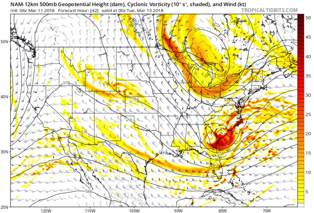
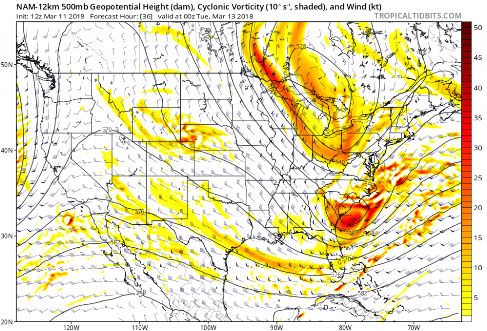
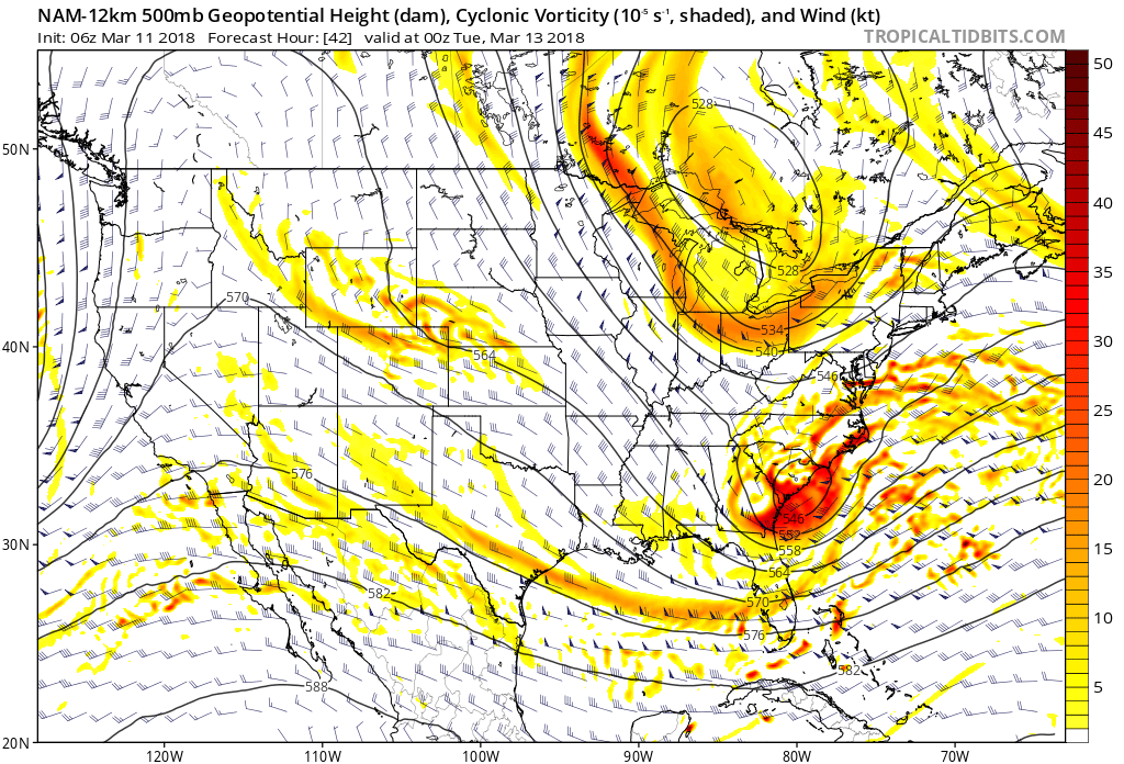
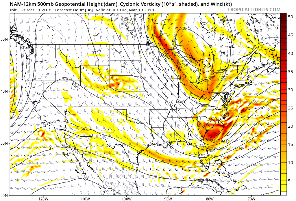
For those of you who will be painstakingly hitting refresh as the next models roll in, in my opinion, the key to why the 12z NAM was stronger and the precipitation distribution is a bit further west vs 6z is shown right here at 00z Tuesday. Look at the difference in how far south the Northern Vort digs between the 6z run and the 12z run. 6z makes it to Pittsburgh while 12z nearly makes it to Roanoke.
-
6 hours ago, Thunderblizzard said:
Euro looks slightly west.
At the surface the Euro ended up slightly west. Which surprised me based on what I thought looked like a slight east tick at 500. Did Tippy say something about the upper levels looking slight east? I just sped through 10 pages and didn't have time to fully read Tip's diatribes.
49 minutes ago, CoastalWx said:It's also moving along. No stall here.
Yup. Can take that off the table. 18 hr storm.
-
About to cause Tippy some heartburn......but Boxing Day is a top 5 analogue based on our 24 from the CIPS page.
-
My goodness. I would not want to be a forecaster in Brookhaven or Albany..........starting to wonder if precip shield ever gets to them
-
According to mesoanalysis the storm center has dropped from 1004 mb to 996 mb in the last 4 hours. Bombing out has commenced.
-
And take time lapse vids, please
This!!! I just posted on facebook asking anyone who has the capabilites to do this.
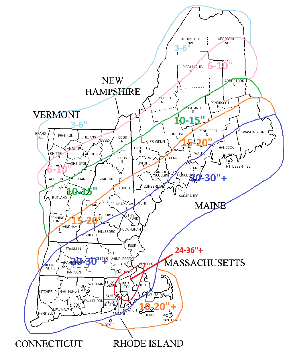
Last map before the storm. Everyone enjoy this.
-
I really feel like cstl SE MA just away from any CF is going to have stupid totals.
Me too. I think they will be the jackpot too. My gut says those totals will be higher than the deform jack. Mostly because aside from the obscene firehose they get and some OES assistance, the snow there may go pretty strong until late Tuesday night.
I keep telling my parents and everyone back in Brockton that they are probably going to take it on the chin with this one.
Told my father that his snowblower probably isn't tall enough.
-
No complaints here from the RGEM.

-
Dec 9th 2005 takes the cake for me as my favorite storm. I left Brockton high at 2 pm that day. It was raining when I walked out of the building. By the time I got to my bus a minute later it was sleeting. By the time we left the parking lot 5 mins later snow was mixing in. Three mins after leaving parking lot it was a whiteout. Got off the bus at around 220 and had to walk in the middle of the road to try to get home. The walk home was the craziest thing I have ever seen. We couldn't see cars coming at us that were 15 feet in front of us. The best part was all the cloud to ground lightning that was striking around us. This went on for about an hour and I probably picked up a good 4 inches in that hour. My favorite winter memory here and it is going to take something insane to top it.
-
Everything is rotating!! This is insane and out of control.....everyones thoughts and prayers have to go out to all those affected by this incredible last couple of days.
-
I think central Mississippi tomorrow will be the place to be. With storms rolling into Alabama towards sundown.
-
I feel like southern Arkansas will be under the gun tomorrow. I like the Clarke, Dallas, Nevada, and Ouachita county section of the state.......but overall the next two days should be incredible from a meteorological standpoint.
March 13th ... west Atlantic bombogenesis type low clipping SE New England, more certain ...may be expanding inland
in New England
Posted
For some reason I never seem to take upslope into account. Probably because I have always lived in the "coastal plain" and have never had to consider it.
No I am not. Too many red flags.