

Wmsptwx
-
Posts
20,730 -
Joined
-
Last visited
Content Type
Profiles
Blogs
Forums
American Weather
Media Demo
Store
Gallery
Posts posted by Wmsptwx
-
-
Looks pretty messy and linear, thinking things stay pretty tame overall.
-
8 minutes ago, buckeyefan1 said:

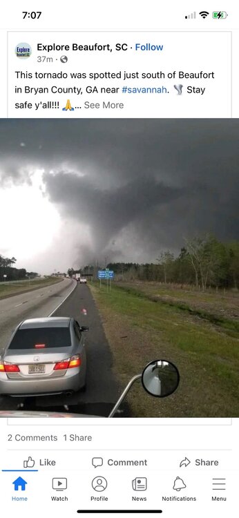
here’s the tornado that is heading towards Beaufort. This is Bryan county in GA. Take cover in Beaufort
Insane…thing is intense.
-
3 minutes ago, buckeyefan1 said:
That's the tornado that was just near Bowman
Thanks to ice and buckeye fan you’ve been great for last hour or so! Also, go Blue!! Sorry I had to lol.
-
11 minutes ago, mob1 said:
TDS just west of Mobile AL
Decent one
-
3 minutes ago, mob1 said:
Wow

Strong tornado
-
 1
1
-
-
-
-
3 minutes ago, Normandy said:
That seems like a pretty significant nighttime tornado event...hopefully it under produces.
Looking like it will, discrete looks unlikely at this point.
-
2
-
-
Any chances of squalls with cold outbreak?
-
1 minute ago, CryHavoc said:
been armchair chasing for two days now from the Bay Area.

Niiiceee
-
1 minute ago, canderson said:
Got pretty lucky it recycled around Slidell. Big pop center around there was in the path. But I think come daybreak we get wild images from the 9th ward.
Central PA boys holding down the severe thread!
-
1
-
-
1 minute ago, canderson said:
Videos from NOLA are bad. Bad bad bad. Homes gone, cars overturned.
Cars flipped and houses destroyed.
-
2 minutes ago, Normandy said:
Surprised there isn't more activity on this event currently on-going. hopefully everyone ins its path is ready
Strangely quiet.
-
FD reporting damage now
-
Impressive looking tornado had subvortice.
-
-
You beat me canderson lol
-
Lol why is it so dead here…confirmed tornado in New Orleans.
-
5
-
-
6 minutes ago, vman722 said:
Certainly looks like it has a pretty well defined area of low level rotation on radar but looks like it would be really tough to get a good look through the rain around it. Also looks like the main line will be impacting it more shortly if it doesn't start taking more of a jog E. Curious if any of the smaller cells further south can organize more.
Those cells imo are going to be what defines today. Though line certainly couldn’t produce damaging spin up variety tornadoes.
-
-
10 minutes ago, stormdragonwx said:
So with tomorrow, are we thinking the SPC will be more or less likely to pull the trigger on going High Risk in wake of what happened today?
Likely to stay mod if I had to guess.
-
3
-
-
How will this effect tomorrow’s event?
-
23 minutes ago, canderson said:
A&M’s campus is gonna be under the gun within 20 or so mins. Looks like a TOG near Snook headed directly that way.
Timmer is on storm
-
1 hour ago, losetoa6 said:
A few of My 10 sec Buick GN pics


Beautiful
-
 1
1
-


April 10th - April 13th(?) Severe Weather, Moderate risk in place for Iowa today
in Central/Western States
Posted
Haven’t seen a CC or impressive presentation yet…is it too far from good radar?