
LovingGulfLows
-
Posts
758 -
Joined
-
Last visited
Content Type
Profiles
Blogs
Forums
American Weather
Media Demo
Store
Gallery
Posts posted by LovingGulfLows
-
-
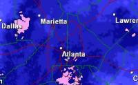
The meso low is present on the surface maps right now. You can see a warm front pushing against the arctic front in SC and parts of NC.
http://www.wpc.ncep.noaa.gov/html/sfc-zoom.php
-
Just now, NCSNOW said:
That's hour 16. I'd wait and see hrb17,18,19 . You'll see once precip starts cooling bottom of the column and more blue showing up. You have to cool from top down in most locations , need rates.
This is hour 18 on the 23z.

-
HRRR is kind of a disaster for almost all of NC...why did it warm so much???
-
4 minutes ago, packbacker said:
Last January the NAM and the HRRR were great for showing the rain/snow cutoff. The HRRR wouldn’t budge and it was right.
Well it looks like this time around, they're diverging. HRRR trending slightly cooler and NAM is trending slightly warmer. HRRR is way better for the Atlanta area than the recent 18z NAM run/
-
1 minute ago, shahroz98 said:
Warm nose over me causing the models to lessen the totals. If it ends up verifying, its going to be the 3rd storm in a row where i got warm nosed and the next county over has atleast 2 inches on the ground ):
It's called climatology. Now large parts of the Atlanta metro is even struggling with 850 mb temps. Not surprised. It looks really similar to January's storm.
-
9 minutes ago, Cheeznado said:
This is a big shift for the GEFS- previous runs had half of the members a trace or nothing.
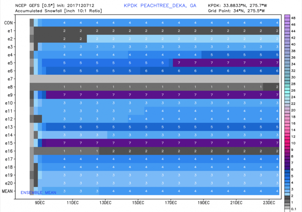
Surprised you're still so hung up on the GEFS...it was a huge failure last winter. Every member had me getting at least 2 inches of snow in the January storm. Nada.
-
Just now, mackerel_sky said:
Dynamic, it's making its own cold air!
Seriously, the RAP did the same thing in January. Showed my area getting heavy snowfall through dynamic cooling; In the end, nothing but rain with some sleet mixed in all day and snow showers and flurries the last hour or two. It puts too much emphasis on cooling the colomn along with overestimating the rates of precipitation. There's not going to be a wide area where rates overcome 35-37 degree temperatures.
-
The RAP always seems colder than actuality with these winter storms. Wouldn't put much hope into it. I'd go with the NAM 3km and the HRRR for my goto hi-res models when it comes to warm noses and thermal profiles. The RGEM also tends to do fairly well. The RGEM/NAM 3km combo nailed the big bust in January.
-
 3
3
-
-
1 minute ago, shahroz98 said:
Is there a warm nose near Atlanta or NE Ga ? Im new to some of this stiff so I can't really tell
Not really. Some mixing issues at the start, but quickly changes over to snow before the heaviest precip gets there so a good event for Atlanta in honesty. Of course, this is only based on the 18z 3KM NAM model run.
-
1
-
-
3 minutes ago, snowlover91 said:
Yep and that's a much more realistic depiction of what the NAM is seeing and lines up with soundings far better. I'm just guessing here but I think Tidbits will see stuff as "snow" on the NAM maps if the surface temp is 33-35, that seems to be a common problem with the map and it did the same with the January storm earlier this year. I like the Kuchera better since it seems to show what would be snow based on soundings and a full atmosphere profile.
I-85 storm to a tee from Alabama through NC with the widest part of the axis through GA.
-
2 minutes ago, snowlover91 said:
I wouldn't use that map, I'm not sure what it uses to determine what is "snow" but soundings indicate rain for a large portion of those areas. The Kuchera ratio will give you a much better idea of where areas might see snow.
Yeah that's odd. Even on the projected radar of the 3KM NAM, those areas are rain pretty much through hour 60. Here's the projected radar at hour 56 on the 3km.

Not sure where that snowfall on that map is coming from for the eastern half of NC.
-
I love the look of the 3km NAM for my area. Snow from Hour 47-56 so far.
EDIT: Looks like snow fom Hour 47-58, then scattered snow showers and flurries after. Don't seem to have much problems with mixing or warm nose...last year, 3KM NAM showed the eventual mixing issues I would have.
-
3 minutes ago, Lookout said:
i'd say it's a little better

Euro adds to yet another model showing that warm bubble in East GA/Upstate SC lol. Limiting any real chance of decent accumulation there. Everything I'm seeing says you want to either be North or West of Atlanta when this thing hits. Sucks for me and other East metro residents, but not surprised.
-
3
-
-
4 minutes ago, griteater said:
UKMet 850 and Sfc Temp panels are out. It runs the 850 low thru the heart of GA to NC. Looks really good for GA mtns to NC mtns...iffy just east of there
Might actually be decent for the Atlanta area this time around. In the January 2017 storm, the 850 mb low went slightly to the north of Atlanta if I recall so the warmer 850 winds are coming in from the southwest and could never change over quickly enough. If it actually goes South of Atlanta, I might be a little more confident this time around.
-
Literally every model shows the warmer air in Athens/East GA area....the cold air simply can't make it over the mountains fast enough during the heart of the storm.
-
3 minutes ago, griteater said:
It's banging on the heavy rates scouring out the low level warmth. Tough forecast.
If we learned anything from January this year, warm noses are not easy to "scour out". I'd be very skeptical of models showing heavy snow through dynamic cooling.
-
1 minute ago, cbmclean said:
My wife's sister live in Graham. I thought about suggesting we take a trip over there tomorrow but the roads might not be safe.
Yeah that is true.
Kind of sucks that I lost so much sleep watching this system via models over the last few days and get nothing for it, but a ton of cold rain.
-
12 minutes ago, cbmclean said:
Last year we got a little dusting on our deck. My daughter (1 and a half at the time) had enormous fun building a little snowman and everything. She has been asking for more snow ever since. I have been looking forward all week to waking her up on Saturday morning with a white covering and seeing the look on her face. Man, I am actually embarrassed to be as upset as I am, but I cannot help it.
You should take a weekend trip to the mountains with her.
-
1 minute ago, Supercane said:
Yeah the usual NW trend really screwed us over. The HRRR and NAM are interesting enough to keep watching in the very slim chance this overperforms -- but no reason to expect more than an inch of snow (and extra sleet) in the southern half of Wake given the issues you outlined, imo.
These winter storm systems rarely rarely overperform. It's funny. After these types of storms are over, more often than not, people are complaining that they were dryslotted or precip. ended much earlier then modeled.
It's just amazing how we can get so much precip. in the winter(December - Feb averages over 12 inches here in the Atlanta area), yet the occurance of a snowstorm actually giving you big numbers(12+ inches) is so incredibly, incredibly rare....in fact, it's not happened once in Atlanta in the last 100 years.
-
Seriously, this might be the worst storm yet over the last 5 years when it comes to teasing me about a good snow, then having nothing but a 33 degree cold rain. At least the other ones had sleet or freezing rain mixed in. That being said, not nearly as dissapointed because I had a huge reality check last night when the 0z Euro came in and it agreed with the NAM and RGEM. Just 24 hours ago, 100% of GEFS members had me getting at least 3 inches...I'm not even sure if I'll get a dusting at the very end.
Note to Self in the future: When the Euro and NAM agree, lock that solution in.
-
Honestly, didn't some SC folks get a rare November snow in 2015?
-
5 minutes ago, snowinnc said:
As irritated as I am with this damn cold rain in Wake County I am happy for the posters in Atlanta, NW GA and NW SC. They always seem to get left out of the fun so I'm glad they are finally getting some snow. That being said, posters in the Triad need to stop being so dang greedy with their snow! Heck, I'd be thrilled with a sleet pellet right now!
Atlanta is not really getting snow though. I certainly am not. So frustrating. Every year a storm teases me to get 3+ inches and I end up with mostly rain/ice/sleet with snow on the back edge that just barely covers the yard and that's it. Even during the 2014 Atlanta snowjam, my area was no more than an inch of snow/sleet and ice. I guess this is nature's way of getting back at me for having 3 stellar winters in a row(2009-2011). It's trying to make this entire decade a dud for my area.
-
You can hide his signature if you want by pressing the "X" at the top right of his signature...
The December to Remember 7th-8th blue turd winter threat thread.
in Southeastern States
Posted
Pretty large dry slot going through GA right now...was this modeled?