
LovingGulfLows
-
Posts
758 -
Joined
-
Last visited
Content Type
Profiles
Blogs
Forums
American Weather
Media Demo
Store
Gallery
Posts posted by LovingGulfLows
-
-
8 minutes ago, Windspeed said:
The eyewall looked to be reorganizing the past few hours on radar prior to the hiatus in update about 30 minutes ago. No surprise that the CDO is taking off again with a notable hot tower in progress on satellite. Likely due to intense convection wrapping around the northern semicircle of the vortex. It appears Fiona is strengthening again.

That southerly moist fetch over PR is straight up nasty. I can't imagine what some of the final rain totals may look like.
-
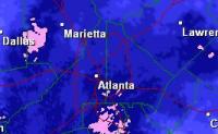
Snow breaking out all over metro Atlanta now.
-
 4
4
-
 1
1
-
-
An ATL-based meteorologist suspects the backside of the system might overperform in AL/GA tomorrow.
-
1
-
-
High wind warning issued for N GA.
-
1
-
-
11 minutes ago, SnowGoose69 said:
I wouldn’t be shocked at all it NRN-CNTRL MS AL GA see fairly significant snows. That upper low is fairly strong. You don’t usually see a 500 low that strong without fairly significant snow somewhere. The NAM does show snows wrapping behind it but at this time it’s very light
Yup. That's what I've been banking on...honestly the comma head on the NAM is impressive in MS. They're getting pounded on.
-
2
-
-
3 minutes ago, SnowGoose69 said:
The worst thing I saw from the 12Z Euro for N GA/N SC is the system was slower which allowed the wedge to establish itself more and cause more FZRA. I thought to myself last night the 500setup out west and in the MS Valley is conducive to this thing probably digging down more in the MS Valley but maybe also slowing down. The more it slows the further SW that wedge will be able to build
It's interesting because the ICON also shows some backend snow for N GA(And Atlanta area) that's associated with the ULL overhead. I think it's possible Atlanta could see some backend snow as the ULL passes overhead. The more this thing digs, the higher the possibility that can happen. Temps at that point would be more than conductive for snow.
-
1
-
-
3 minutes ago, STILL N OF PIKE said:
What is their all time record ?
25 inches. They're most likely going to get between 30-36 inches.
-
Looks like the NAM scored here. It had the main precip axis further north than other models. Cheyenne is going to shatter their all-time record.
-
Light snow being reported in Cumming, GA(40 miles north of Atlanta). Bolds well for you guys in NE GA/Upstate SC/Piedmont NC.
-
 2
2
-
-
2 minutes ago, burrel2 said:
3km nam has douglasville, Georgia at 42/37 with rain at 4pm. At 4pm, Douglas cold is 37.2/34.0 with .03 inches in the bucket.
Interesting....
Evidently it's snowing in Douglasville per this video:
-
3
-
-
Was Goni ever actually measured by an aircraft or was it just an estimate also? That storm could've also been over rated by satellite measurements.
-
Just now, the ghost of leroy said:
dvorak is fake news
I was kind of thinking the same thing. Did this expose Dvorak?
-
I was looking at Maria and Irma IR/SAT pictures at their peaks and this core looks better than Maria's, but not quite Irma's at it's peak yet. I'll go with 175 MPH/925mb.
-
They went with 120 MPH...no way with that presentation, the winds aren't higher.
-
We're never going to hear the end of it from the ghost of leroy.
-
4
-
 1
1
-
-
18z GFS very interesting for GA at hour 72.

-
1
-
-
4 minutes ago, SnowGoose69 said:
ATL just got NAM'd on the 18Z run... .30 snow
It's literally looks almost like the 2000 analogy you were saying earlier. East and Southeast sides gets lollipopped....west parts of the metro get shafted. Still, it's the NAM.
-
1 hour ago, SnowGoose69 said:
It looks anafontal to me. I don’t know how often anafrontal snow occurs there but I’m sure it’s not a common setup
We had one last year in Mid January. Dropped 1-2 inches in the metro...it really exploded over NC though.
-
1 hour ago, SnowGoose69 said:
The GFS will squash southern waves like that at this range. It loves the northern stream and hates the southern stream. Taken literally based on the pattern the Op Euro is too far to the east with the track anyway. That system would probably track further west if it dug that much into the Gulf
Interesting that you're usually pessimistic about ATL's chances, but it feels different for this system as if you see a chance for us.
-
1
-
 1
1
-
-
Funny how I posted this three weeks ago and look what happened....
On 11/19/2018 at 2:47 PM, LovingGulfLows said:If Atlanta can get an early December snowstorm that drops 5+ inches, then Charlotte certainly can with the right pattern.
-
There doesn't seem to be enough instability for thundersnow....I'd imagine when the Upper level energy tracks closer to the Carolinas, there would be more thundersnow reports.
-
20 minutes ago, kvegas-wx said:
Watching CLT piss away all this QPF just trying to drop 5 degrees has me worried for the Triad. If we get to 1am and all I see are posts about mixing, virga and nothing yet, the majority of this board is going to start having flashbacks. Its never easy here......ever.
I do feel bad for those in SC and GA that invested heavily and are coming up empty. You need another surprise 6" snow in downtown ATL!
Don't think anyone in Atlanta expected anything substantial from this storm. It's just fun to follow winter storms in the SE.
-
This system is pretty far suppressed so far. I think folks in VA might get whiffed outside of the southern portion and even they might not get much.
-
1 hour ago, Queencitywx said:
I could be wrong but I just think it's too early. If we were talking about christmas, I'd feel much better. There hasnt been a significant early December snowstorm in Charlotte, for instance, since 1971. Before that, you have to go all the way back to the 1880s and 1890s.
If Atlanta can get an early December snowstorm that drops 5+ inches, then Charlotte certainly can with the right pattern.
-
2
-
Hurricane Ian
in Tropical Headquarters
Posted