

NGTim
-
Posts
312 -
Joined
-
Last visited
Content Type
Profiles
Blogs
Forums
American Weather
Media Demo
Store
Gallery
Posts posted by NGTim
-
-
thats pretty cool looking
-
 1
1
-
-
3 hours ago, MotoWeatherman said:
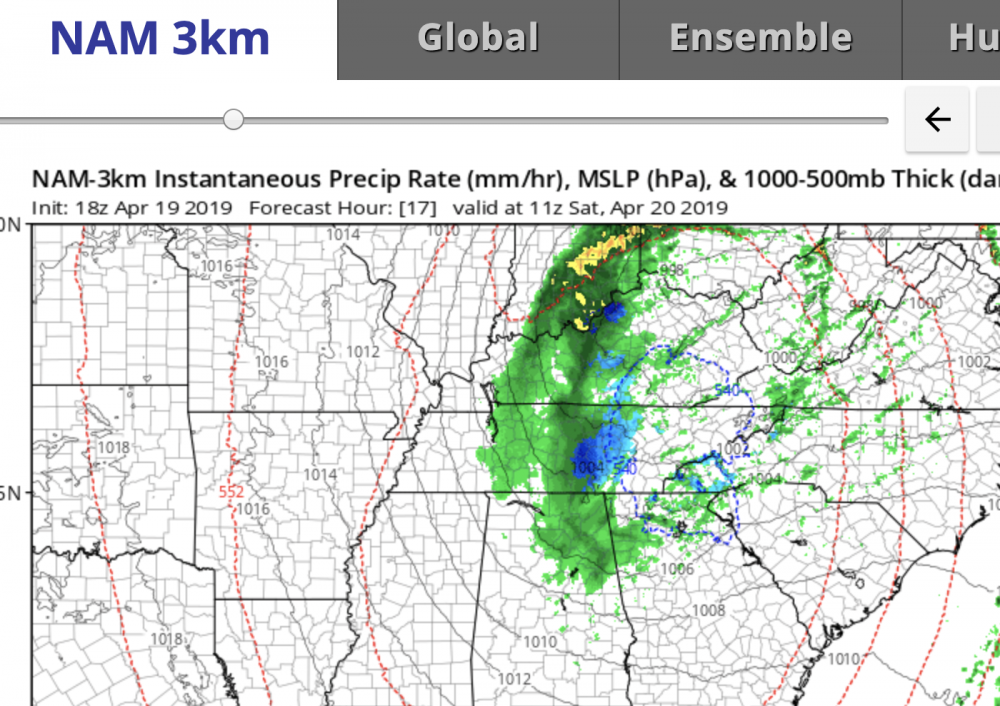
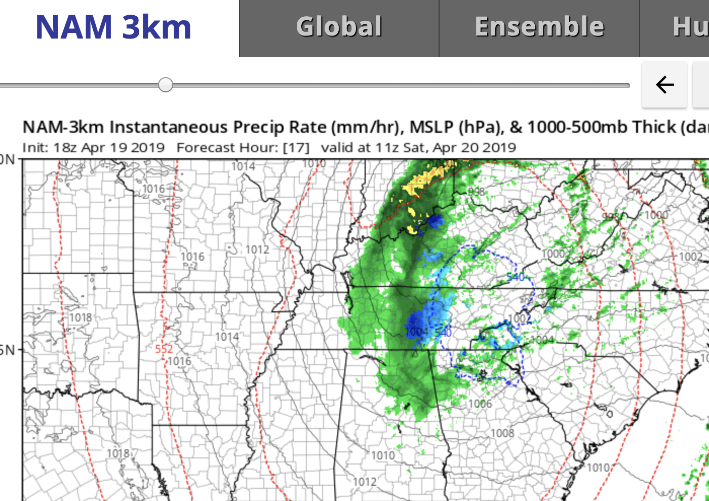
Here are the Kuchera and 10:1 maps. 3k Nam is very bullish on backside moisture swinging down through northern Al and then GA and then up through western NC. Basically around the base of the ULL. In my opinion I think elevations over 4k are good for 2+ inches while everyone else will struggle with surface temps for accumulations. We are getting closer to the wheel house range of the 3k NAM (inside 24hrs) so it can't be ignored despite the rest of the other models looking BLEH.
i'm watching this myself for my little meteorologist in my family Moto, so please keep updating, and if you could slide that map over toward highlands or maggie valley a bit i'd appreciate it! I guess i could look myself, but you are the man. and yes. about 3.5 inches of rain between midnight and noon here. crazy. clay creek falls is wild. Question, is this going to be convective type snow with the big fluffy flakes? heck its even fun to get under small hail in these setups if this is that kind.
Also was orig thinking if we go anywhere we'd go tonight, but timing wise Ray seems to indicate the snow levels will be dropping more Sat evening.
-
2 hours ago, Iceagewhereartthou said:
I'm so jealous of you guys, feels like we never had a winter here in the upstate and now we're looking at temps 10-15 above normal for the forseeable future after a "coolish" Sat. Been nice the past few days and mornings but the heat is coming.
don't be too jealous, I haven't had snow imby in NE GA since Dec 2017. I did see snow few weeks ago heading through the upstate, but not till after Greenville. The good thing is, the older i get, the quicker summer comes and goes . (but also i guess winters seem quicker too on the other hand, but I'll worry about that next year).
-
this is crazy. i'm actually thinking "when is this winter going to end", only because I know i'm going to be tempted to do another road trip! I had seen this on TT, but started getting excited when I saw Met1995 post about it and Moto too. Some other things that are lining up. my iphone weather app had snow icon for Saturday in Suches, Ray has been talking about it, and now WXSouth. Sheesh.
-
2
-
-
daughter is really taking it hard no snow since Dec 2017. its about a 3 hour trip for me to get to soco gap above Maggie Valley. not really convenient to road trip today, and hoping for something next week, just curious what yall are seeing in addition to what Buckethead already reporting.
-
Couldn't chase Sat night because of family obligations, so we left out of GA on Sunday morning, and headed up through Clayton toward Asheville. In hindsight probably should have gone up 85 and then to Asheville and maybe could have seen some falling before lunch. So we were between the front end and back end, and had to get back Sunday night. Saw snow on the ground soon as I crossed the county line out of Lumpkin co. Waynesville was lot of snow, and Asheville was beautiful. We walked all around and even found a place open to eat pizza, so not too bad. Even though nothing falling from the sky, decided to go home via Hendersonville and I 85 cause had seen they got hit pretty hard . (didn't have time to head toward Beech/Boone). Stopped at Ingles in H-ville and the snow piles were crazy. Kids got to play in the fresh snow there and sled a bit. They all said it was the deepest they'd ever walked in, so that was good. it was like cement. I would have loved to see that come down. I am about to write a break up letter to snow, cause seems i just can not re-create that 18 inches i experienced in the second grade. But its my fault, not the snow. One day, One day, I am going to get in a two footer. I may have to retire first. But I did just want to say congrats to all in this thread, cause I enjoy following and reading all winter long, and am happy that I think most of you got a widespread hammering. Here's to hoping for more of the same as we get into the heart of winter. One thing I really enjoyed was watching this thing modeled way out on the FV3, and not really believing it, and wondering if this new model was just crazy, or this was just good timing for it to make its winter debut.
-
2
-
-
thats good will need it to melt that 20 inches i'm gonna get at my house in N GA on the 9th and 10th according to the 12z GFS.
I know, I know, clown map, misrepresentation of snow vs other p types, 10 days out, etc. But gosh its cool to look at as todays run is as close as I'll get to something like that. -
it is actually snowing here in Dahlonega GA. its really really really small, but i can see it in the floodlights.
-
4
-
-
1 hour ago, Shack said:
Tornado Warning and Hurricane Warning in Houston County(Warner Robins/Perry GA)
Fox24 has a pic of a supposed touchdown in Ft. Valley, but can't tell where. i was following it cause my parents live off Hwy 96 west of the Ft. Valley.
-
man, not sure exactly what this means, but i can't stop reading it from the afd. I so want to be in the deformation zone.
but an
advective more large scale forcing interacting with a developing
Gulf/coastal low pressure system and the enhanced risk for convective
banding of heavier snow within the northern deformation zone.
Given the
possible liquid equivalent moisture and snow to liquid ratios upwards
of 12:1 /possibly higher at times/...a band could quickly dump a few
inches within an hour. Some high res models that resolve convective
processes explicitly are indicating multiple bands...though some
discrepancy on exact location.
-
according to peachtree city, i have the potential to get 7 inches! But... i can also expect to get AT LEAST 0 inches. This is gonna be fun.
-
8 minutes ago, magpiemaniac said:
I agree. It doesn't give them a lot more needed wiggle room without becoming overly vague.
yes. and they are fun as heck to look at as well. it really is unfair that they are expected to tell to the inch how much it is going to snow and exactly where, and that is just not possible in GA where so many things can go wrong, as opposed to other areas that don't have two oceans, and and nearby mountains to deal with. So in addition to the wiggle room, it also provides us the public with more info. Its a brilliant win-win in my mind. They ask for feedback since its experimental, and I've already given it high grades. I am curious to watch it in it first debut storm.
-
13 minutes ago, magpiemaniac said:
I don't envy the mets at the Peachtree City NWS office right now. They must be flustered.
i think the new "at least this much, most likely, and potential for this much" winter products are going to help them out as they don't have to put out just one number and then get grilled on it, for a situation that is going to be very variable over such a large area.
-
ok, serious question. since this is a gulf low, is there any chance that Saturday we will be moaning about thunderstorms in the gulf robbing moisture and creating a dryslot for someone who would have otherwise got good moisture?
I asked this in the main thread the other day (i thought it was a valid question) but i think it might have been considered trolling or something. Probably best to leave the storm thread for mets anyway to not clutter it up even with questions.
But it just seems so many times like this when we have a gulf low and we feel confident we are going to get a good thumping (maybe not necessarily my backyard, but somebody in N. GA) and then all of a sudden there is a dryslot and i hear that the moisture was robbed by thunderstorms in the gulf. I have not heard anyone discussing this and just wondered if the this is NOT something to worry about with this storm.
-
They say we all have a twin somewhere right?
lets see a pic

-
me and my scruff, been out of work from neck surgery since oct
Oconee, when I saw your picture, I almost fell out of my chair. you and I could be twins, or at least brothers.
2019 Mountains and Foothills Spring/Summer thread
in Southeastern States
Posted
Pouring snow plott balsam overlook on blue ridge parkway