

TheManWithNoFace
-
Posts
463 -
Joined
Content Type
Profiles
Blogs
Forums
American Weather
Media Demo
Store
Gallery
Posts posted by TheManWithNoFace
-
-
I don't think we've discussed much the elongated, lobed depiction of the surface low along the coastal front much. It's been shown this way in various solutions. The 12z RGEM takes this to the extreme, with meso lows chasing convection east of the benchmark, competing for supremacy with the sfc low trying to establish east of the VA capes with where there's better UL support for sfc low development. The result is the forcing is strung out and discombobulated and steadier snows do not advance into NNJ or SNY. I don't see why this isn't just as plausible as anything else.
-
Just now, SnoSki14 said:
That should really help consolidate the energy and it makes it more likely to be tucked in further west.
This feels like a system where the amounts will go up as we get closer. I think the odds of a whiff are shrinking.
With you. Think there's a strong cutoff, but those that get "in it" are going to realize some of the heftier totals. I like Monmouth County for a 12+ jackpot.
-
 1
1
-
-
We've had a lot of discussion, rightly so, on the western Atlantic and it's potential to squash things. I haven't seen the PAC mentioned as much which is trending more favorably, with better wave spacing all the way into the north central Pacific resulting in improved ridging over the western US.
.thumb.gif.f72f586fc52d7449336085cc337e2dba.gif)
-
2
-
-
3 minutes ago, Blizzardo said:
I was in it. 63 hours straight. Pulled into a driveway with a 15 foot drift. I'll never forget.
I'm jelly
-
2
-
-
I feel like the wind today was undersold. Nws point and click had gusts to 35 for most of NJ, seeing widespread 40-55 gusts. Cold is legit.
-
18 minutes ago, weatherpruf said:
The are a day late and a dollar short. We had people here saying this and getting slammed. When I hear warm air aloft and coastal winds, it ain't gonna be a big snow for most of us. But it was still ok. Looks real nice. Just a normal type of event for around here. If its the first of a few, that's fine. If it's the only shot of the winter, well we're getting used to that too. If anything, I thought the sleet held off a bit to give us a decent 3-6 event for a lot of us, and there were a number of people here who said 2-4/3-6. Will go to bed and test the new snow blowers tomorrow. Think the little electric toro can do the whole job, but gotta try out the big one.
That's my point. Upton is the plumb job of the weather planet right? How can anyone in that office be talking about surface winds/temps when half the hobbyists understand that it's about what's aloft?
-
7 minutes ago, USCG RS said:
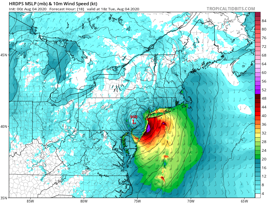
NEAR TERM /THROUGH THURSDAY/...
While there have been areas of heavy snow the last couple of
hours, the most organized band of heavy snow has worked north
of the region. To the south, the precipitation has become more
disjointed with reports of sleet working in across the NYC metro
and Long Island. There could be some wavering the next couple
of hours as intensity varies, but it appears NYC and Long Island
will not see much more in the way of heavy snow. There could
still be an additional 6 or more inches across the Lower Hudson
Valley, interior NE NJ, and southern CT through the end of the
event. Across the NYC metro and Long Island, perhaps an
additional 1 to 3 inches. This could be pushing it, but it will
depend on how quickly the cold air can be drawn back in around
the surface low passing to the south in the morning.

Thus, the storm total snow has been adjusted downward with as
little as 3 to 5 inches across eastern Long Island, 5 to 10
inches across the NYC metro and western Long Island, and 10 to
15 inches to the north. This downward trend may have to be
continued with subsequent updates depending on the evolution of
the precipitation shield to the south and west as a strong
negatively tilted shortwave trough approaches the region.
Regional radar clearly shows back filling on the radar across
the northern Mid Atlantic region, which will pivot NE.

Gust NE to E winds will become more northerly as the low pulls
east towards daybreak, which will allow colder air to filter
back into the region, possibly changing precipitation back to
snow toward the end of the event.

NE winds could gust to 35-45 mph across much of the area overnight,
with gusts to 45-55 mph possible across far eastern Long Island.
This will result in limited visibilities, but with mainly mixed
precipitation with the strongest winds, visibilities will
generally be greater than a 1/4 mile.
OKX discussion from 2307 16 December 2020
I don't understand. It's not about cold air wrapping around the sfc low. It's about resaturating the column and mid level lift.
-
HRRR gives north/Central NJ another 4-8". Column is unsaturated, wind is ripping up ratios, this will underperform totals.
-
39 minutes ago, wxman said:
Love, you Walt, and your a pros pro, of course.....but "To me one bad sign... too much sun 6-8 hrs before an event starts. The classics have a long slow process of thickening and lowering cigs." I mean, really? That sounds like something I might say, LOL. In any event, clouds are lowering and thickening here. Best of luck to all!
I'd take Drags anecdotes over Bernie Rayo using a low sfc dewpoint as reasoning as to why it won't change to sleet in NYC.
-
5 hours ago, Will - Rutgers said:
Plenty of trees at 35 feet.
not too many anenometers though.
-
5 minutes ago, Blizzard-on-GFS said:

Nearly all of the MESO models show an intense band of roughly 60 MPH sustained winds making its way up the barrier islands of NJ. It's hard to believe but almost every model has it. Gusts would be even higher. I know it's crazy but these winds would probably warrant a hurricane warning for these areas; I doubt the warnings will be hoisted but it will be interesting to see how bad it gets.
Thats 35 feet up.
-
I think I'd go crazy if my biggest snowfall was in November. "We are off to an incredible start!"
-
If you're going to play a "whoops" card, at least take advantage! :-)
-
DT has a new last call map

Saw that and it still looks over done.
-
He lowered his snow totals an hour ago...
I wasn't speaking to his forecast at this moment, more his predictable tendencies. He's like JB, easy to guess what they're going to say. Now as for his current forecast...significant snow event for the NYC metro? Significant ice event for the Philly metro? SouthernNJ changes to plain rain by NINE AM? we should never judge a forecast until its fallen, but he is still presenting the wintriest forecast you can find out there.
-
Steve D is insufferable and predictable. He is always on the cold/snow side of things, and when models trend against him, he "takes a break" or "takes a nap" for a cycle so he can see if things came back into his favor. Now today he needs a reason to go missing for a but because he is still forecasting a more wintry scenario, so he tweets that he is "receiving violent threats" and needs to protect his family. So dramatic.
-
Looks like News12 is trying out the probabilistic approach. Don't think people are going to go with it.
-
Dave Curren
Dan Skeldon
-
-
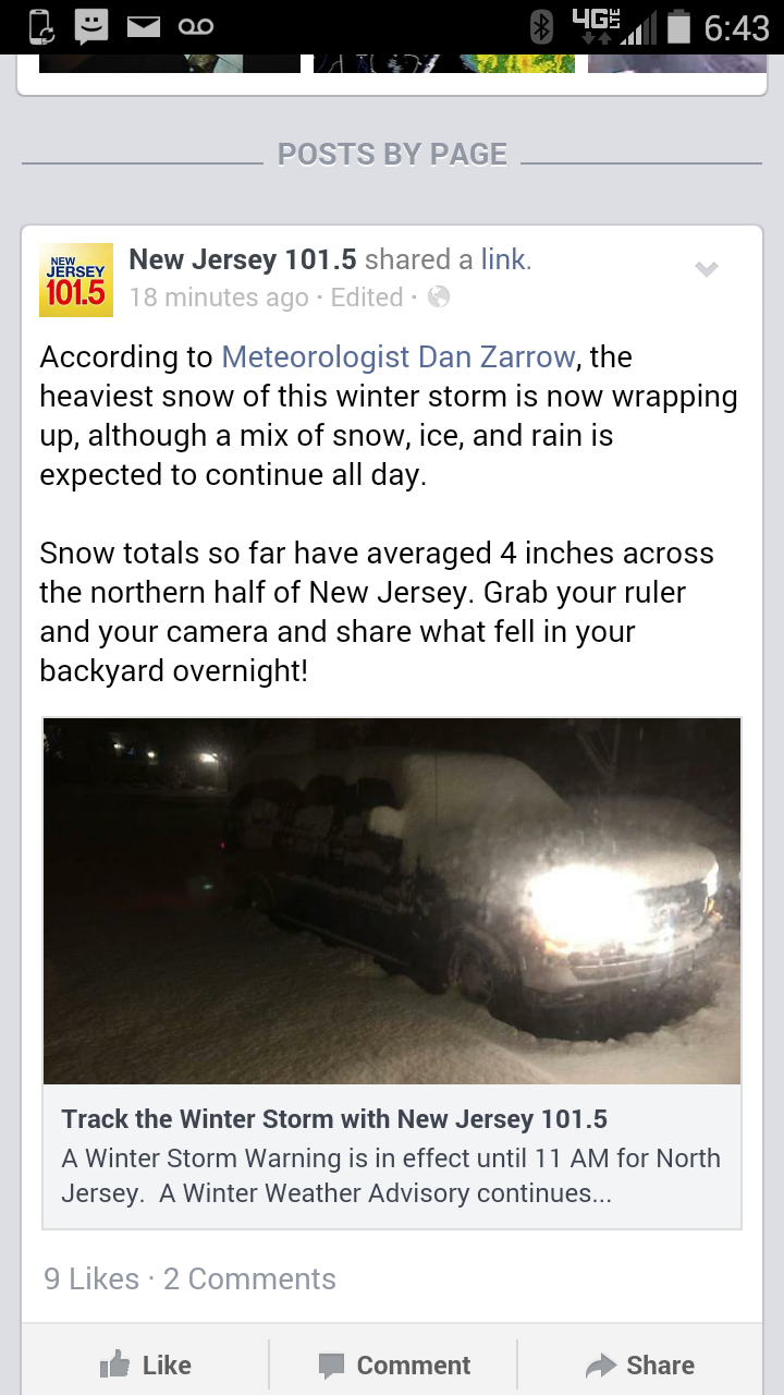
Pretty shameful spin job by 101.5. I heard a dreadful forecast with Dan Zarrow's name on it last night around 8pm for "4inches north and west of the turnpike."
This morning they try to play it off like that was a good call. Average of 4" in north NJ? Must have missed the NWS p.I.s. Pretty sure snow fell south of the turnpike too.

.gif.8873b916025e73fd81deaeaf3f8e2599.gif)


Major Nor'easter near blizzard (6"+ most of our area-best chance 20-30" north of I78 in ne PA, nw NJ, se NYS)-ice-rain-power outage NYC subforum late Sunday Jan 31-early Tue Feb 2.
in New York City Metro
Posted
Globals have shown this too though. I think there's going to be some competing interests in the low/midlevels that could spoil forcing from consolidating and delivering the big numbers.