ice1972
-
Posts
25,802 -
Joined
-
Last visited
Content Type
Profiles
Blogs
Forums
American Weather
Media Demo
Store
Gallery
Everything posted by ice1972
-

The August 21, 2017 Great American Eclipse
ice1972 replied to ice1972's topic in Weather Forecasting and Discussion
IDK man pulling off the road and just sleeping in the car seems, at best, weird......I booked a hotel in Quincy, IL for $128 - right on the Mississippi River.....lol I booked it tonight.....its only 2 hrs from the totality path.....early Monday I plan to leave for Fayette, MO......112 miles......theres no interstates to Fayette and I don't have to cross any major interstates to get there.....stay north of I-70.....really have no idea what to expect.....gonna be a fun few days either way -
The August 21, 2017 Great American Eclipse
ice1972 replied to ice1972's topic in Weather Forecasting and Discussion
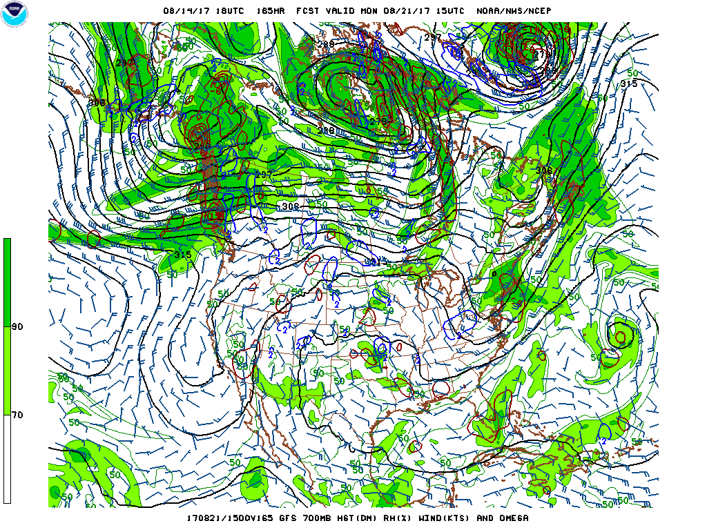
Great thanks.....I just checked 18z GFS 700 RH and it looks great on Monday for the entire path....I didn't check cover maps but so far this is looking like epic viewing coast to coast....not staying up for 0z......new target is Fayette, MO......its just north of the centerline on the 2min 30sec totality line.......someone suggested being a bit north of the line....I mean its only a few miles north lol This is great.......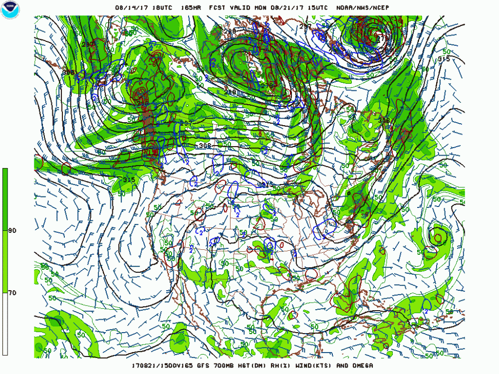
-
The August 21, 2017 Great American Eclipse
ice1972 replied to ice1972's topic in Weather Forecasting and Discussion
For what part of the path? Southeast? Plains? -
The August 21, 2017 Great American Eclipse
ice1972 replied to ice1972's topic in Weather Forecasting and Discussion
Bookmarked....thanks -
The August 21, 2017 Great American Eclipse
ice1972 replied to ice1972's topic in Weather Forecasting and Discussion
Just checked AT&T service in central Nebraska.....mega lolz.....that could be a deal breaker forcing me to Missouri.....lol -
The August 21, 2017 Great American Eclipse
ice1972 replied to ice1972's topic in Weather Forecasting and Discussion
GFS shows nice little dome of high pressure right over WY.....lol 200 hr models -
The August 21, 2017 Great American Eclipse
ice1972 replied to ice1972's topic in Weather Forecasting and Discussion
Ya I initially wanted to.....but booked to Madison already.....I didn't want to pay $1000.....you meeting up with anyone down there? -
The August 21, 2017 Great American Eclipse
ice1972 replied to ice1972's topic in Weather Forecasting and Discussion
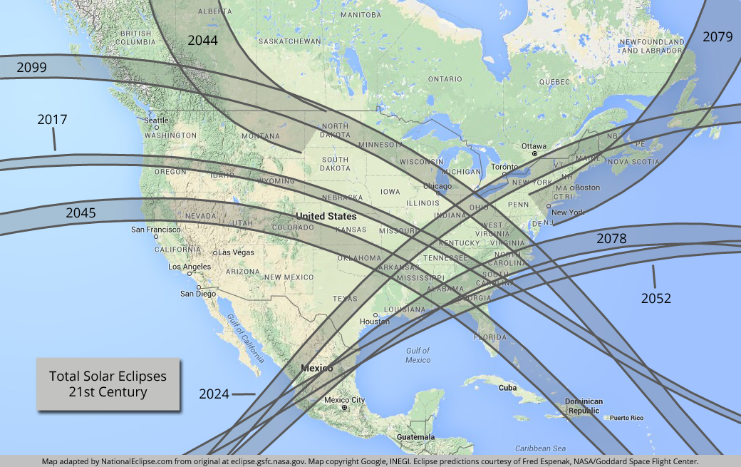
Thank you....the sunrise/sunset thing makes perfect sense...like I knew what was happening but didn't correlate it to sunset/sunrise..... So in Montana if you were to position yourself right at the end the sun would go down in totality.....that could be a great look..... https://eclipse.gsfc.nasa.gov/SEanimate/SEanimate2001/SE2044Aug23T.GIF -
The August 21, 2017 Great American Eclipse
ice1972 replied to ice1972's topic in Weather Forecasting and Discussion
Should I just get in place the night before and rough it in the car or get a place a couple hours away and then go in the morning? I mean it's Nebraska - maybe Missouri - we're talking about here.....or is it just gonna be a sea oh humanity..... -
The August 21, 2017 Great American Eclipse
ice1972 replied to ice1972's topic in Weather Forecasting and Discussion
It doesn't "end" suddenly.....it's just that's the spot where the shadow falls off the face of the planet......what's depicted is the area that sees a total before that happens so the end - while maybe not exactly straight like that due to curvature - seems like it just stops...... -
The August 21, 2017 Great American Eclipse
ice1972 replied to ice1972's topic in Weather Forecasting and Discussion
Lots of options coming south out of Wisconsin -
The August 21, 2017 Great American Eclipse
ice1972 replied to ice1972's topic in Weather Forecasting and Discussion
Might be adjusting plans for Missouri now -
The August 21, 2017 Great American Eclipse
ice1972 replied to ice1972's topic in Weather Forecasting and Discussion
Strike that......make it the next four.....I'll be 80 come 2052......lol -
The August 21, 2017 Great American Eclipse
ice1972 replied to ice1972's topic in Weather Forecasting and Discussion
I think my chances are good to see the next three totals here in the US.....2024, 2044, and 2045......after that lol -
The August 21, 2017 Great American Eclipse
ice1972 replied to ice1972's topic in Weather Forecasting and Discussion
I decided to go to Nebraska....further west lowers chance of cloud cover, save a synoptic system or something.....it looks very very rural out there.....I'll fly into Madison WI Saturday....rent the car and then drive to Omaha I think.....but Injavent booked room cuz I wanted to think about traffic on Monday morning and whether I want to be locked in.....maybe I'll just sleep in the car somewhere.....anyway haven't picked target yet but Broken Bow or Ravenna seem like nice spots away from 80.....probably would take the back roads whole way in.....this is gonna be insane.....then after it's over I'll head back to Madison.....lol....fly out Tuesday morning -
The August 21, 2017 Great American Eclipse
ice1972 replied to ice1972's topic in Weather Forecasting and Discussion
It's getting close guys......booked into Madison WI then will drive toward Omaha.....about 7 hrs.....will spend night in hotel and then drive into total zone Monday morning based on cloud cover.....can't wait -
The August 21, 2017 Great American Eclipse
ice1972 replied to ice1972's topic in Weather Forecasting and Discussion
I'm looking at flyingnin to Madison WI and then driving into the totality zone on the 20th.....hopefully I can get in and set up in time....looking at getting back to Madison and staying overnight at a friends house and catching flight back to Boston on Tuesday....price was under $400 which was lol -
The August 21, 2017 Great American Eclipse
ice1972 replied to ice1972's topic in Weather Forecasting and Discussion
****.....that's not a good look on the 0z GFS for the IL/KY are -
The August 21, 2017 Great American Eclipse
ice1972 replied to ice1972's topic in Weather Forecasting and Discussion
Also gotta be ready to relocate early if the forecast sucks ass......need to pick out 2 or 3 spots 200-400 miles away that I could reasonably get to......eclipse in my target region is like 1pm ish......could relocate if left early enough on the morning of the 21st......#ItsTooComplicated -
The August 21, 2017 Great American Eclipse
ice1972 replied to ice1972's topic in Weather Forecasting and Discussion
This is a great site......I'm late to the party in planning but I'm thinking of flying to Atlanta and then driving to TN/KY/IL area and spending the night......if its in my car I don't care.....these maps help in deciding where there may be delays due to traffic and idiots......thinking I fly on the 20th and then just drive to my viewing spot.....gotta think I need to be in position early.......can't wait -
The August 21, 2017 Great American Eclipse
ice1972 replied to ice1972's topic in Weather Forecasting and Discussion
Wow.....really a tremendous stretch of totals for the US inbound......starting with this year......I expect I'll be able to see the 2024 one in northern VT or upstate NY.....maybe my cards play right and I can get to Montana in 44 and then go home to NorCal in 45......52 decent chance - I'd only be 80.......after that I'm done.....too bad I'd have to make it to 107 to be bullseye in West Hartford in 79.....maybe....first things first.....2017 and one hell of a drive
-
The August 21, 2017 Great American Eclipse
ice1972 replied to ice1972's topic in Weather Forecasting and Discussion
Planning my trip now......I'm late to the party a bit but I've got a high school friend that lives in Nashville so I've hit her up on FB.....either I crash with her or find a cheap ass place within driving distance of totality that I can get to in the morning.....he'll maybe even just drive there in the middle of the night given the expected traffic problems....I don't mind crashing in my car for a few if I have to..... I know Fella is going to Nashville and maybe a few others here.....have you guys picked out secluded rural spots along centerline or are you just gonna stay at your hotel? -
Really really want to chase this one....thinking gonna target Nashville....anybody in?
-
Central/Western Medium-Long Range Discussion
ice1972 replied to andyhb's topic in Central/Western States
What is up in the Bay Area? Is that really an inch of rain NE of SJO? Man.....very slow moving....flooding risk? Mid may is crazy late for rain....