

Wannabehippie
-
Posts
14,173 -
Joined
-
Last visited
Content Type
Profiles
Blogs
Forums
American Weather
Media Demo
Store
Gallery
Posts posted by Wannabehippie
-
-
Skies are starting to darken by me. Mets have postponed their game for tonight, so I guess they are expecting enough rain to come thru Flushing Queens this evening. I would not mind a good thunderstorm.
-
3 hours ago, SACRUS said:
See if something minimal pops over FL

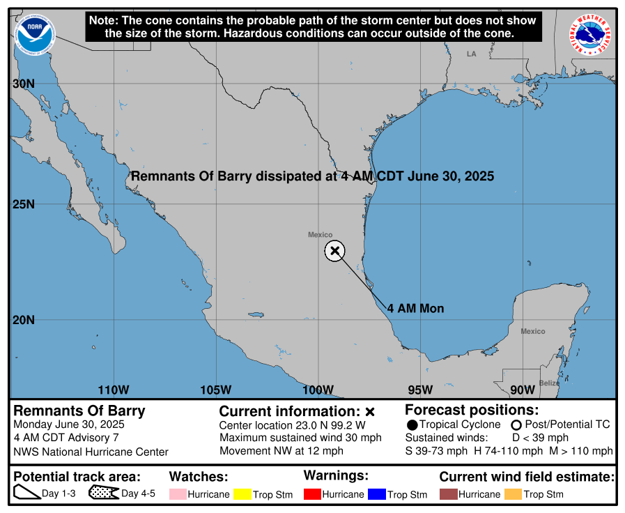
Looks like Barry will be on shore around 1am Monday.
-
-
 2
2
-
-
21 hours ago, bluewave said:
The NAM is finally getting replaced after they stop updating it in March 2017.
Public Information Statement 25-41
National Weather Service Headquarters Silver Spring, MD
845 AM EDT Thu Jun 26 2025
To: Subscribers:
-NOAA Weather Wire Service
-Emergency Managers Weather Information Network
-NOAAPORT
Other NWS Partners, Users and Employees
From: Richard Bandy
Acting Director
NCEP/Environmental Modeling Center
Subject: Soliciting Comments on Proposed Discontinuation of the North
American Mesoscale (NAM) model and other Regional Modeling Systems to be
Replaced by the Rapid Refresh Forecast System (RRFS) through July 26,
2025.
The Environmental Modeling Center (EMC) at the National Centers for
Environmental Prediction (NCEP) is working towards replacing the North
American Mesoscale (NAM) model, the High Resolution Window (HiresW) aside
from the Guam domain, the High Resolution Ensemble Forecast (HREF) and
the North American Rapid Refresh Ensemble (NARRE) systems with the
implementation of the Rapid Refresh Forecast System (RRFS) in early 2026.
The NWS is seeking comments on this proposed change through July 26,
2025.
This transition to RRFS would provide an hourly updating modeling system
over a North America region at 3 km horizontal grid spacing, which,
combined with the model retirements, would greatly unify and simplify the
“convective scale” (approximately 3 km grid spacing) regional models
within the NWS operational modeling suite.
As a deterministic system running to 84 h, the RRFS would fully retire
the NAM, and nearly fully retire the HiresW (aside from the Guam domain).
As an ensemble forecast system, the RRFS Ensemble Forecast System (REFS)
would fully retire the HREF and NARRE systems.
The deterministic RRFS generates full domain output at 3 km grid spacing,
and subset grid output over the contiguous United States (CONUS) and
Alaska (AK) (at 3 km grid spacing), and Hawaii (HI) and Puerto Rico (PR)
(at 2.5 km grid spacing). The RRFS will also provide output from a
separate 1.5 km RRFS fire weather run, with output provided over a 5 x 5
degree rotated latitude longitude region. Details of the RRFS output
grids are available in
https://www.emc.ncep.noaa.gov/mmb/mpyle/rrfs_info/rrfs_grids.txt
Relative differences between RRFS output products and the proposed-to-be-
retired system products will be discussed individually by the modeling
Is there any link to this news? I want to be able to share it around.
Thanks.-
1
-
-
21 hours ago, donsutherland1 said:
Tomorrow will be unseasonably cool. The mercury could struggle to reach 70° in New York City. It should rise into the lower 70s at Newark.
The chilly highs will challenge the record for lowest high temperatures two days after an 80° or above low at Central Park, JFK Airport, and Newark. The existing records are below:
Central Park: 71°, July 9, 1883
JFK Airport: 76°, July 23, 2019
Newark: 76°, July 23, 2019All of those readings followed lows of 80° two days earlier.
Central Park has had 72 lows of 80° or above; Newark has had 50; and, JFK Airport has had 16.
Temperatures will return mainly to the lower 80s for the remainder of June. Excessive heat does not appear likely to return in the near-term.
The ENSO Region 1+2 anomaly was +1.0°C and the Region 3.4 anomaly was 0.2°C for the week centered around June 18. For the past six weeks, the ENSO Region 1+2 anomaly has averaged +0.47°C and the ENSO Region 3.4 anomaly has averaged -0.03°C. Neutral ENSO conditions will likely continue through at least late summer.
The SOI was +12.65 yesterday.
The preliminary Arctic Oscillation (AO) was +1.073 today.
Based on sensitivity analysis applied to the latest guidance, there is an implied 93% probability that New York City will have a warmer than normal June (1991-2020 normal). June will likely finish with a mean temperature near 73.1° (1.1° above normal).
I would love to get a weekend pattern where both Saturday, and Sunday are warm, sunny.
-
2
-
-
100 in Riverdale NJ today.
-
1
-
-
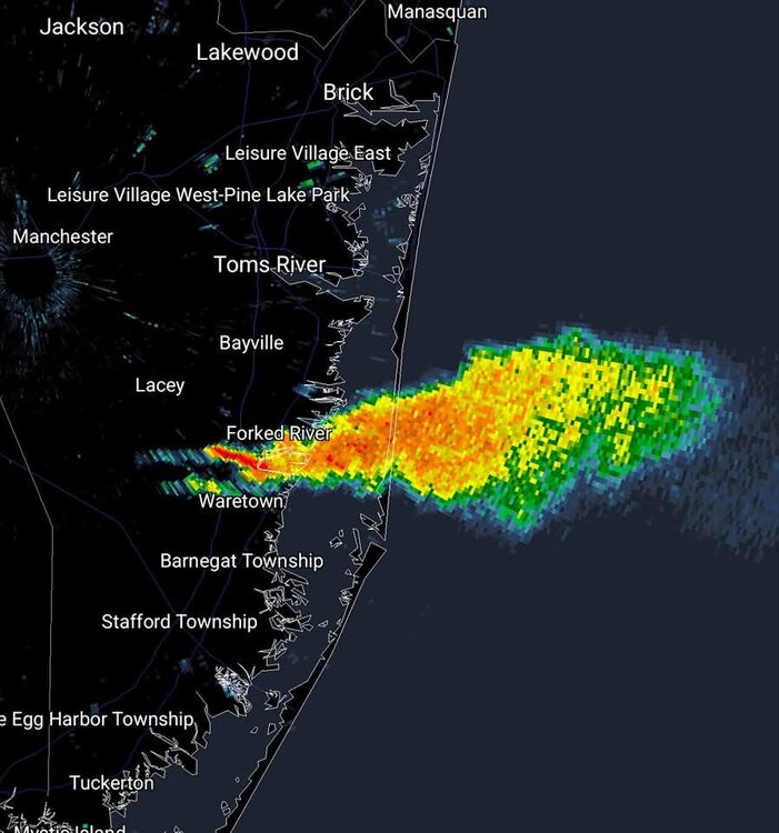
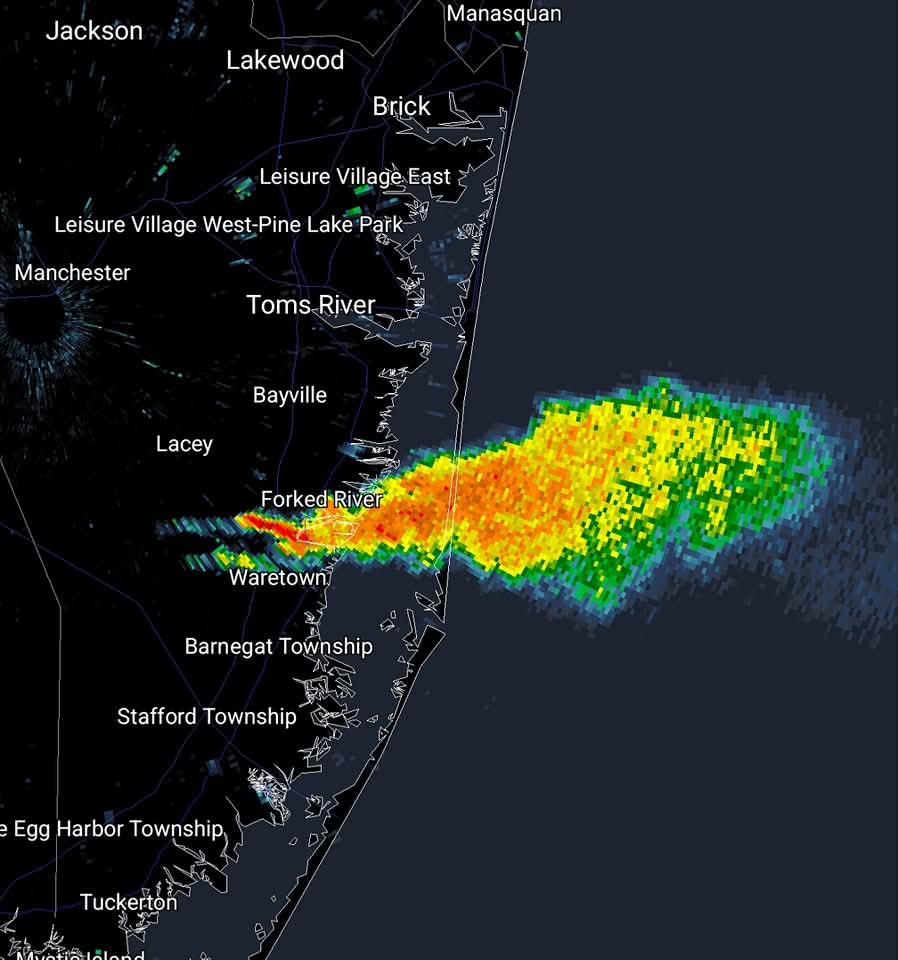
Did any models predict these mesoscale storms?
-
57 minutes ago, donsutherland1 said:
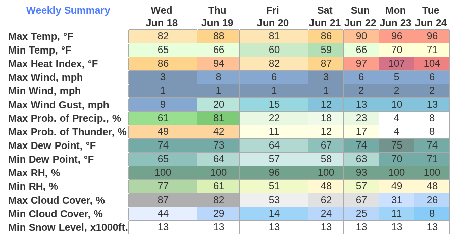
A sustained period of above normal temperatures is now underway. Excessive heat will overspread the region tomorrow with the mercury soaring into the 90s across the region.
Extreme heat is likely Monday, Tuesday, and possibly Wednesday Temperatures will likely top out in the middle and upper 90s in the New York City area and upper 90s to lower 100s in the hot spots in New Jersey. The ECMWF and GFS continue to show potential June monthly record heat for parts of the region.
June Monthly Records:
Bridgeport: 97°, June 9, 2008
Islip: 96°, June 24, 1966 and June 19, 1994
New York City-Central Park: 101°, June 29, 1934 and June 27, 1966
New York City-JFK Airport: 99°, June 29, 1949, June 26, 1952, June 30, 1964
New York City-LaGuardia Airport: 101°, June 26, 1952 and June 13, 2017
Newark: 103°, June 27, 1952June 26, 1952 is currently the hottest June day on record in and around the New York City area. Out of the five stations from the above list that were operating in 1952, three reached or exceeded 100° on June 26, 1952 (Central Park: 100°, LaGuardia Airport: 101°, and Newark: 102°). All five reached 95° or above. Two stations also saw 80° or above lows: Central Park: 81° and LaGuardia Airport: 84°. Both the number of 100° highs and 80° lows is the highest on record for June for this five-station area.
For June 26, 1952, the five-station average high was 99.4°, the average low was 78.2°, and the mean was 88.4°. The average high and mean are the highest on record for June. The average low is the second highest on record for June. June 21, 2012 was the second hottest day, overall, in this region. Its average high was 96.8°. Its average low was 78.4°. Its mean was 87.6°. That average low was the highest on record for June. The average high and mean were the second highest for June.
The ENSO Region 1+2 anomaly was +0.5°C and the Region 3.4 anomaly was 0.0°C for the week centered around June 11. For the past six weeks, the ENSO Region 1+2 anomaly has averaged +0.30°C and the ENSO Region 3.4 anomaly has averaged -0.05°C. Neutral ENSO conditions will likely continue through at least late summer.
The SOI was +2.11 yesterday.
The preliminary Arctic Oscillation (AO) was +0.206 today.
Based on sensitivity analysis applied to the latest guidance, there is an implied 84% probability that New York City will have a warmer than normal June (1991-2020 normal). June will likely finish with a mean temperature near 73.8° (1.8° above normal).
Will we get an old fashioned heat wave with 90+ temps that lasts at least 5 days?
-
1
-
-
4 hours ago, Sundog said:
18z NAM has a seabreeze for Monday as well. But it gets close to 100 before it drops us into the 80s and 70s east of the city.
How much of a sea breeze will there be in places like Long Branch NJ on Monday?
-
45 minutes ago, LibertyBell said:
a 15 year old
Thankfully they are conscious, and alert. Taken to hospital as a precaution.
-
1
-
-
Skies grew dark here in Riverdale, NJ, but the storm missed us. Not even a few drops of rain, or a flash of lightning, rumble of thunder.
-
1
-
-
7 hours ago, LibertyBell said:
The solution is to average out NYC, EWR, JFK, LGA and then you get the full of range of weather in New York City (which covers 5 boroughs). I believe LGA runs too hot now, look at how elevated their lows are compared to everyone else and it has the highest concentration of traffic now, which is much worse now than it was during the 30s-50s period when NYC was hotter (as was JFK.)
Where does LGA have its weather station now? Those tarmacs can definitely skew any temperatures upwards.
-
1
-
-
I wonder if we will get an old fashioned heat wave, 5+ days of 90+ temps, coming up this weekend in to next week.
-
29 minutes ago, crossbowftw3 said:
Not fun!
The heat index predicted for Sun - Tues are very dangerous. Take care of yourselves those days everyone.
-
1
-
-
Not directly related to what is discussed here, but still important, given the weather predictions coming up. If not appropriate to post here, I apologize in advance.

-
3
-
-
1 hour ago, LibertyBell said:
https://community.netweather.tv/topic/69523-heat-bursts/
Sometimes known as heat flashes these are a pretty rare phenomenon. These have been well documented in the US and South Africa and are caused by either by a downburst of air from collapsing thunderstorms or from katabatic downsloping of hot air funneled and focussed through mountain valleys.
There are apocryphal reports of incredible heat bursts temperatures: 188F in Abadan, Iran, 158F near Lisbon, and 152F at Antalya, Turkey. The hottest certified heat burst temperature was 110F recorded at Kimberly, South Africa, during the passage of a thunderstorm.
The temperature rose from from 67F at 2100 to 110F at 2105 and then fell back to 67F by 2145.
Stumbled on this by chance in my archives
A letter by F. B. Parkinson of Madibi Mines in Kimberley South Africa
"At 9pm on the 20th September 1911, a thunder cloud approached from the west, bringing with it a squall of wind that caused the temperature to rise in a few minutes to 110F. By 9.45pm, it had fallen again to 67F which I expect the temperature before the squall. I do not think my thermometer responded quick enough to register the highest point but it is safe to say it rose 40F in 5 minutes."
Here's a recent one which occurred in Adelaide in early 2009:
"On the morning of January 29, an exceptional nocturnal heat event occurred in the northern suburbs of Adelaide around 3 a.m. Strong northwesterly winds mixed hot air aloft to the surface. At RAAF Edinburgh, the temperature rose to 107°F (41.7°C) at 3:04 am. Such an event appears to be without known precedent in southern Australia."
Those temperature swings are insane. I am surprised no cattle or humans were killed or seriously injured by a heat burst that raised the temp 40 degrees in 5 minutes.
I cannot think of any way that a heat burst like that could be predicted.-
1
-
-
1 hour ago, WestBabylonWeather said:
I’m from Nassau. Cant pay me to deal with Long Beach parking. Babylon town beaches for the win. Don’t regret the move
Jones Beach field 6 FTW.
-
7 minutes ago, donsutherland1 said:
Following today's warmth, tomorrow will be somewhat cooler. Temperatures will top out near 80°. It will turn noticeably cooler for the weekend with temperatures reaching only the upper 60s and lower 70s in New York City.
Showers and periods of rain are also likely during the weekend, especially Saturday afternoon and Sunday. Rainfall amounts will generally be light with most of the region seeing 0.25" or less rainfall.
No exceptional heat appears likely through the first three weeks of June. However, a sustained peirod of above normal temperatures could develop starting late next week.
The ENSO Region 1+2 anomaly was +0.4°C and the Region 3.4 anomaly was 0.0°C for the week centered around June 4. For the past six weeks, the ENSO Region 1+2 anomaly has averaged +0.23°C and the ENSO Region 3.4 anomaly has averaged -0.07°C. Neutral ENSO conditions will likely continue through at least mid summer.
The SOI was -5.27 yesterday.
The preliminary Arctic Oscillation (AO) was -0.172 today.
Based on sensitivity analysis applied to the latest guidance, there is an implied 61% probability that New York City will have a warmer than normal June (1991-2020 normal). June will likely finish with a mean temperature near 73.1° (1.1° above normal).
Any chances of a pattern change coming up, so we can get a nice weekend for a change? I am craving sitting by the community pool, getting my vitamin D from the sun.
-
2
-
-
34 minutes ago, LibertyBell said:
My neighbors are complete morons. The rains came and dowsed their fire so they poured oil on the fire which then caused it to flare up and almost ended up burning themselves and their 5 year old kid who was dancing around the fire.
Darwin award runner ups.
-
 1
1
-
-
The rain appears to have missed the Bronx entirely, as the Yankee v Boston game continued with no signs of rain.
I am hoping we break out of this pattern of rain on the weekends, especially during daylight hours, so I can take advantage of the pool in my community development. Plus warm sunny days will help heat up the pool, as it is not heated.-
1
-
-
8 hours ago, SACRUS said:
SST Anomaly


Am I reading this map correctly, temps in the Gulf Stream are below normal pretty much all the way from the coast of the Carolinas to more than midway to the UK?
-
54 minutes ago, LibertyBell said:
we're going to have to learn how to pump that shit into outer space.
They did a whole thing on ABC today for Earth Day about a certain kind of sand that absorbs CO2. If sand can absorb CO2 and remove it from the air, then we can also pump excess water vapor into outer space. Get rid of two greenhouse gases at once.
I would rather find a way to capture that water vapor so it can be converted to clean drinking water.
-
1
-
-
2 hours ago, Stormlover74 said:
Big time
Wow. I hope they get it under control quickly.
-
Is a Neutral ENSO expected for this summer? I know that a La Nina MIGHT lessen shear in the Atlantic and might mean more hurricanes/TS in that basin.
June 2025 discussion-obs: Summerlike
in New York City Metro
Posted
We have had some nice rumbles of thunder by me in NJ.