

Wannabehippie
-
Posts
14,679 -
Joined
-
Last visited
Content Type
Profiles
Blogs
Forums
American Weather
Media Demo
Store
Gallery
Posts posted by Wannabehippie
-
-
Forward speed really picking up now.
2:00 PM EDT Thu Oct 30
Location: 29.0°N 70.9°W
Moving: NE at 30 mph
Min pressure: 964 mb
Max sustained: 105 mph -
50 minutes ago, NorthHillsWx said:
Looks like the storm might come close to major again. Really getting its act together this morning on both satellite and recon
I am not sure it will, due to the fact that the system, wind field will expand as it moves north, making it harder to get back to major status. Melissa's lowest pressure is 965mb at the moment.
-
1 minute ago, olafminesaw said:
Also, fresh convection trying to rebuild an eye. Just continues it's legendary journey
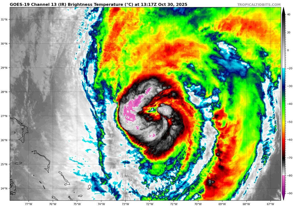
Trying to rebuild an eye, but it is definitely open to the NE. Looks like shear is inhibiting outflow to the SE quadrant, maybe some dry air being entrained in as well? Starting to really pick up forward speed now as well at 21mph.
8:00 AM EDT Thu Oct 30
Location: 26.8°N 72.7°W
Moving: NNE at 21 mph
Min pressure: 965 mb
Max sustained: 105 mph -
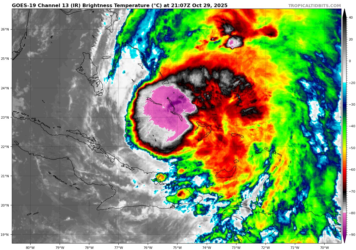
5:00 PM EDT Wed Oct 29
Location: 22.9°N 74.8°W
Moving: NE at 16 mph
Min pressure: 974 mb
Max sustained: 90 mph -
Maybe an eye trying to form again? That little dot of a different color in the center of that pink and purple?
-
1 minute ago, kvegas-wx said:
All I can think about regarding the recovery is mold. Everywhere. Helene was terrible here in the NC mountains with mold remediation needs. But in Jamaica with no power for months and the high heat and humidity, its going to be awful. Lot of folks starting over there. And they should seriously be looking at concrete printed homes. Never a better case study than now.
Lots of homes in Jamaica were already built that way,
-
4 minutes ago, Hotair said:
And add to the fact that this isn’t a large country with thousands of roofing companies willing to travel to a disaster area. The workforce there is limited as are the tools (cranes, materials, etc). Many of those places will not be rebuilt for at least 3 years or longer.
Now also consider that the percentage of homes covered by insurance in Jamaica is roughly under 5%.
Jamaica is a member of the British Commonwealth of Nations. Which means aid will be coming in from all over the world, along with people that will help rebuild the infrastructure, buildings etc.
-
Water vapor loop, shows dry air and shear to Melissa's west, which is also giving it the kick to move to the NE. Its forward speed is up to 16MPH.
blob:https://www.tropicaltidbits.com/d28d79c9-b1dc-4880-a36a-8269bda320bd
-
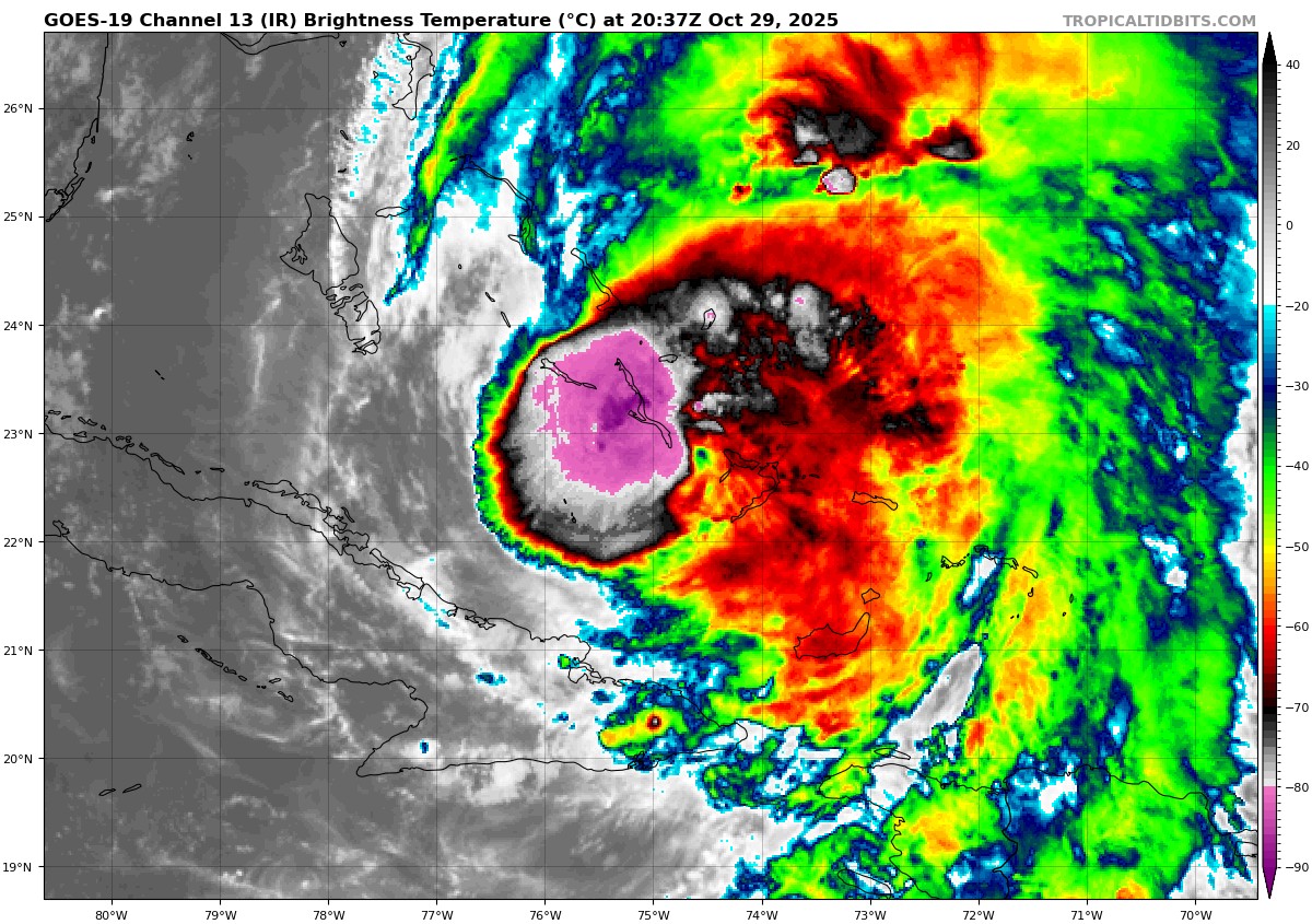
Western semicircle not looking great. Lots of deep convection near the center of circulation.
-
Between Jamaica and Cuba, Melissa got torn apart a bit. Pressure is up to 976, definitely not as healthy as it was yesterday.

-
 2
2
-
-
-
3 minutes ago, WxWatcher007 said:
Center sonde has a 954mb reading with 6kt wind so despite the satellite appearance, it hasn’t translated into strength in a substantial way yet. Obviously still need to see the SW and NE quadrants.
I am not sure the plane got dead center of the hurricane.
https://www.tropicaltidbits.com/recon/recon_AF301-2613A-MELISSA.png
https://www.tropicaltidbits.com/recon/recon_AF301-2613A-MELISSA_dropsondes.png-
1
-
-
11:00 PM EDT Tue Oct 28
Location: 19.3°N 76.6°W
Moving: NE at 9 mph
Min pressure: 950 mb
Max sustained: 130 mph-
1
-
-

If fhose really intense pink colored convection can wrap completely wrap around the center, will we see it reach cat 5 status again before it hits Cuba? Or will it only make it to Cat 3-4?
-
25 minutes ago, NorthHillsWx said:
Warming near center. Eye about to reappear
18 minutes ago, CoastalWx said:Yeah definitely better looking now.
Looks like the eye will be large than before if this picture is any indication.

-
952 on first pass, so pretty close to what NHC said at 5pm EDT advisory.
https://www.tropicaltidbits.com/recon/recon_NOAA2-2513A-MELISSA.png
https://www.tropicaltidbits.com/recon/recon_NOAA2-2513A-MELISSA.png
-
 1
1
-
-
3 minutes ago, CoastalWx said:
Highly doubt winds are close to that.
We probably will find out soon, with the airplanes in there now.
What do you think the winds are at? -
Just now, WxWatcher007 said:
Recon is in there (only one flight from what I see) and it looks like the center weakened substantially based on initial data.
5pm EDT advisory has it as a very dangerous cat 4 storm.
5:00 PM EDT Tue Oct 28
Location: 18.5°N 77.7°W
Moving: NNE at 8 mph
Min pressure: 921 mb
Max sustained: 145 mph
-
-
1 hour ago, Interstate said:
It is bitter sweet watching the eye collapse right in front of our eyes.
Not a surprise given how high some of those mountains are in Jamaica. They do a number on any tropical system. But the eye is about to hit the water again, so time will tell if if re-strengthens once it hits the bathwater temps north of Jamaica
-
9 minutes ago, Scott747 said:
This is total bs.
You won't find one video of any chaser standing directly in legit sustained major hurricane/typhoon winds.
100% spot on. They will find a place that is sheltered from the wind to broadcast from, or will just hunker down.
-
10 minutes ago, wthrmn654 said:
From that jamaica webcam site only 1 of the cams is now down pretty dam impressive.
As long as the batteries hold out, and they don't get physically blown away, they probably will be able to keep broadcasting. Once their batteries run out, that will be it it for at least a few days.
-
1
-
-
10 minutes ago, Lava Rock said:
can't believe they still have power/internet
Battery power, satellite internet?
-
2
-
-


Major Hurricane Melissa - 892mb - 185mph Jamaica landfall
in Tropical Headquarters
Posted
Melissa is starting to expand in size, which is to be expected as it increases in latitude. But is it also starting to interact with the system affecting the northeast US right now as well?
blob:https://www.tropicaltidbits.com/1f3f0d59-f4f3-4f1e-85b0-d28463901100