

Wannabehippie
-
Posts
14,693 -
Joined
-
Last visited
Content Type
Profiles
Blogs
Forums
American Weather
Media Demo
Store
Gallery
Posts posted by Wannabehippie
-
-
13 minutes ago, Bxstormwatcher360 said:
It's crazy how much bust potential is involved here,any tick s and e and we all back in the game. All it takes is a mile here or 10 miles there. Also 0z gfs ticked cooler. Patterson,nj is now the furthest west the rain falls.
The Euro has been pretty consistent.
-
1 hour ago, snywx said:
You will be above freezing before any precipitation falls
Yeah that ocean wind will raise temps for any coastal areas pretty quick.
I am at 27 right now, which might be the low for the overnight hours.-
 1
1
-
-
2 hours ago, donsutherland1 said:
All New York City area locations saw below normal precipitation.

Thank you for this info
-
1
-
-
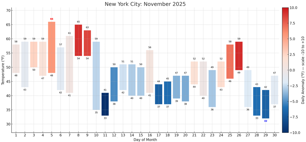
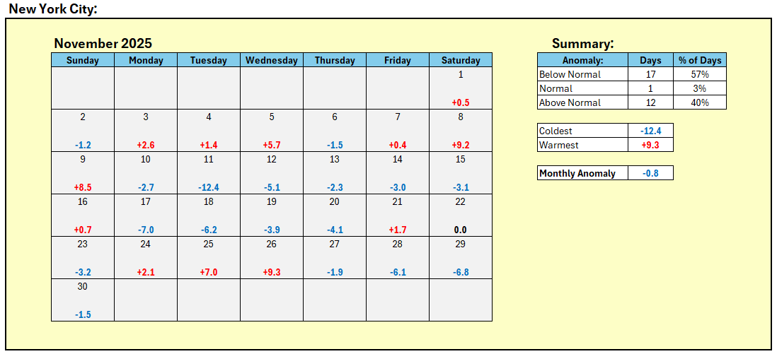
6 hours ago, donsutherland1 said:
November outcomes for New York City:
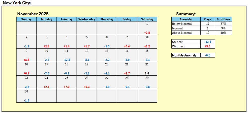
What were the precipitation anomalies?
-
On 11/21/2025 at 1:41 PM, eduggs said:
It responded that it didn't use any papers.
My earlier responses were based on:
-
foundational meteorological knowledge (jet dynamics, cutoff-low behavior, coastal steering, ENSO teleconnections, North Pacific climatology),
-
plus the real-time information I retrieved via your previous queries.
Keep in mind that chatGTP is not the be all and end all of accuracy. it is only as good as the search terms, and what is inputted in to it. Too many variables at this point with it IMHO.
-
 1
1
-
-
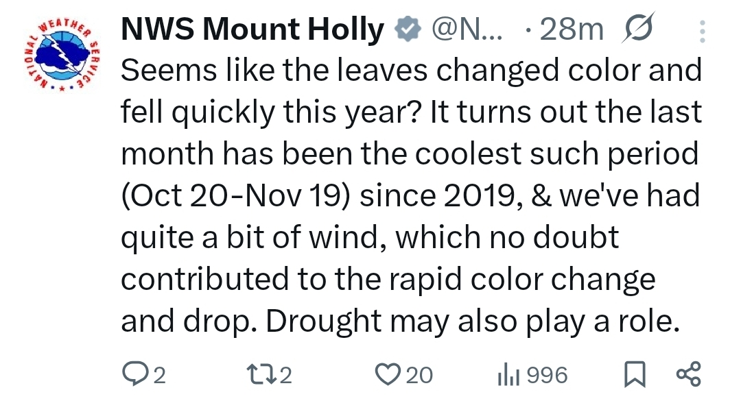
1 hour ago, FPizz said:
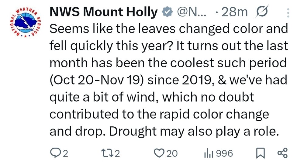
The colors seemed muted this year too, due to the drought.
-
1
-
-
11 hours ago, SACRUS said:
Records:
Highs:
EWR: 71 (1953)
NYC: 71 (1953)
LGA: 72 (1953)
JFK: 64 (2006)
Lows:
EWR: 18 (1933)
NYC: 19 (1933)
LGA: 27 (1959)
JFK: 26 (1959)Historical:
1869 - Southwest winds of hurricane force swept the Berkshire and Green Mountains of New England causing extensive forest and structural damage. (David Ludlum)
1894: The temperature at Oklahoma City, OK fell to 9°, establishing their coldest reading for so early in the season. (Ref. Wilson Wx. History)
1927 - A tornado cut a seventeen mile path across Alexandria and southeastern Washington, DC, injuring 31 persons. The tornado struck the Naval Air Station where a wind gust of 93 mph was recorded. A waterspout was seen over the Potomac River ninety minutes later. (David Ludlum) (The Weather Channel)
1927: A tornado (at times to 260 yards wide) cut a seventeen-mile path through Alexandria, Virginia across the District of Columbia from the Navy yard to Benning Rd. & 19th St. NE and Northeast to East Riverdale, Maryland. This storm injured 31 people. The tornado struck the Naval Air Station where a wind gust of 93 mph was recorded.
1933: A cold wave dropped the minimum temperature to 17 °F in Washington, DC. (Ref. Washington Weather Records - KDCA)1953 - The temperature at Minneapolis, MN, reached 71 degrees, their warmest reading of record for so late in the autumn. (The Weather Channel)
1955: An early season cold snap finally came to an end throughout Montana. Helena, MT experienced 138 consecutive hours of subzero temperatures, including a record low of -16°. Other locations from the Northwest to the southern Plains reporting record lows for the date included: Havre, MT: -26°, Sheridan, WY: -13°, Rapid City, SD: -5°, Billings, MT: -6°, Denver, CO: 5°, Spokane, WA: 9°, TX: 23°-Tied, Dallas (DFW), TX: 26°, Dallas, TX: 29°-Tied. (Ref. Wilson Wx. History)
1958: A deep upper level trough covered most of the west bringing record low temperatures. Bishop, CA recorded a low temperature of 5° which is the coldest November reading ever. This also broke their previous record by 11°. It was 10° in Idyllwild, CA tying their lowest temperature on record for November. Other record low temperatures for the date included: Alamosa, CO: -10°, Casper, WY: -9°, Flagstaff, AZ: -8°, Reno, NV: 1°, Burns, OR: 4°, Tucson, AZ: 24°. (Ref. Wilson Wx. History)
1959: The most severe November cold wave in U.S. history was in progress. Many locations from the Plains to the Appalachians reported record low temperatures: Williston, ND: -10°, Rapid City, SD: -9°, Duluth, MN: -9°, Aberdeen, SD: -8°, Sioux Falls, SD: -7°, St. Cloud, MN: -6°, Sioux City, IA: -4°, Rochester, MN: -4°, Waterloo, IA: -3°, Grand Island, NE: -2°, Scottsbluff, NE: -2°, Des Moines, IA: -2°, Madison, WI: -1°, Marquette, MI: -1°, Green Bay, WI: 0°, La Crosse, WI: 0°, Rockford, IL: 0°, Milwaukee, WI: 1°, Houghton Lake, MI: 1°, Chicago, IL: 3°, Peoria, IL: 3°, Columbia, MO: 4°, Springfield, MO: 4°, Springfield, IL: 4°, Indianapolis, IN: 4°, South Bend, IN: 4°, Ste. St. Marie, MI: 4°, Lincoln, NE: 5°, Topeka, KS: 5°, St. Louis, MO: 6°, Fort Wayne, IN: 6°, Kansas City, MO: 7°, Lansing, MI: 7°, Wichita, KS: 8°, Grand Rapids, MI: 9°, Dayton, OH: 9°, Lubbock, TX: 10°, Evansville, IN: 10°, Cincinnati, OH: 10°, Toledo, OH: 10°, Tulsa, OK: 11°, Pittsburgh, PA: 11°, Lexington, KY: 12°, Paducah, KY: 12°, Detroit, MI: 13°, Columbus, OH: 13°, Louisville, KY: 13°, Buffalo, NY: 13° ,Cleveland, OH: 14° , Wichita Falls, TX: 15°, Rochester, NY: 15° -Tied, Charleston, WV: 16°, Huntington, WV: 16° -Tied, Abilene, TX: 17°, Nashville, TN: 18°, Dallas (DFW), TX: 20°, San Angelo, TX: 20°, Bristol, TN: 20°, Dallas, TX: 21°, Oak Ridge, TN: 24°, Waco, TX: 25°, Austin, TX: 28°, San Antonio, TX: 30°. (Ref. Wilson Wx. History)
1987 - A storm in the Rockies produced 21 inches of snow at the Monarch ski resort in Colorado, with 14 inches reported at Steamboat Springs CO. Early morning thunderstorms in the southeastern U.S. drenched Mary Esther FL with 4.43 inches of rain. Gale force winds over the Great Lakes Region gusted to 49 mph at Johnstown PA. (The National Weather Summary) (Storm Data)
1988 - Another in a series of storms brought heavy snow to the mountains of the western U.S. Totals ranged up to 17 inches at Bob Scott Summit in Nevada. Winds around Reno NV gusted to 80 mph. The Alta and Sundance ski resorts in Utah received 14 inches of snow. (The National Weather Summary) (Storm Data)
1989 - Freezing temperatures overspread the southeastern U.S. in the wake of the severe weather outbreak of the previous two days. Eight cities reported record low temperatures for the date, including Gilbert AR with a reading of 8 degrees. A fast moving storm blanketed the Great Lakes Region and Upper Ohio Valley with snow during the night. Totals ranged up to 12 inches at Pellston MI and Little Valley NY. (The National Weather Summary) (Storm Data)
2008: Santa Ana winds blew across southern California courtesy of high pressure across the Great Basin. Winds gusted over 70 mph in the Santa Ana Mountains and over 60 mph in the northern Inland Empire. The Freeway Complex Fire burned from Corona through Chino Hills and Yorba Linda. This fire destroyed or damaged over 300 homes and four businesses. More than 30,000 acres burned and more than 40,000 evacuated. The ridge was responsible for record high temperatures including: Downtown Los Angeles, CA: 91°, Phoenix, AZ: 87°, Tucson, AZ: 87°, Bakersfield, CA: 84°, Hanford, CA: 82°, Merced, CA: 82°, Fresno, CA: 81°, Las Vegas,NV: 81°, Madera, CA: 80°, Bishop, CA: 77°, San Francisco, VA: 73°-Tied, Eugene, OR: 70°-Tied, Ely, NV: 69°-Tied and Quillayute, WA: 60°. (Ref. Wilson Wx. History)
2013: An unusually powerful storm system spun up five dozen tornadoes from the Great Lakes to the Tennessee Valley. Two EF4 twisters struck Illinois, hitting the communities of Washington and New Minden.
2014: As of the midday hours on Tuesday Nov. 18th, an unofficial snowfall measurement of 60 inches has been recorded in the past 24 hours in Lackawanna, New York, just south of Buffalo. However, snowfall of 4 feet or more has been observed in some of the south towns. Depending on the investigation of snowfall measurement activities, and if the intense snow continues through the evening Tuesday, there is a chance the 24-hour United States snowfall record may fall. That official record belongs to Silver Lake, Colorado, with 76 inches, spanning April 14-15, 1921. A report of snowfall of 77 inches in 24 hours at Montague, New York, was thrown out by officials from January 1997. Snowfall measurement of 60 inches just south of Buffalo, NYAre the two tornadoes in 1927 the same tornado?
-
2 hours ago, bluewave said:
NYC will set the new record this month since we don’t have any daily 4” snowfalls in the forecast. Janaury 2022 was our last month here which was both snowy and cold. From 2010 to 2018 NYC had 36 days with 4” of snowfall vs only 6 days from 2019 to 2025.
Number of Consecutive Days Snowfall < 4
for NY CITY CENTRAL PARK, NY
Click column heading to sort ascending, click again to sort descending.Last value also occurred in one or more previous years. Period of record: 1869-01-01 to 2025-11-12 1 1394 1929-02-22 through 1932-12-16 2 1383 2022-01-30 through 2025-11-12 3 1063 1949-03-01 through 1952-01-27 4 1051 1961-02-05 through 1963-12-22 5 794 1954-01-12 through 1956-03-15 6 743 1996-03-09 through 1998-03-21 7 742 1918-01-23 through 1920-02-03 8 687 1979-02-20 through 1981-01-06 9 685 1972-02-24 through 1974-01-08 10 680 1952-03-02 through 1954-01-10
sort descending. 2024-2025 0 0 2023-2024 0 0 2022-2023 0 0 2021-2022 2 0 2020-2021 4 0 2019-2020 0 0 2018-2019 2 0 2017-2018 5 0 2016-2017 3 0 2015-2016 1 0 2014-2015 6 0 2013-2014 5 0 2012-2013 4 0 2011-2012 1 0 2010-2011 6 0 2009-2010 5 02 hours ago, donsutherland1 said:I agree. I don't see how the record won't be broken.
How far beyond the record will we go. 1415 days? 1430? More? Time will tell.
-
1
-
-
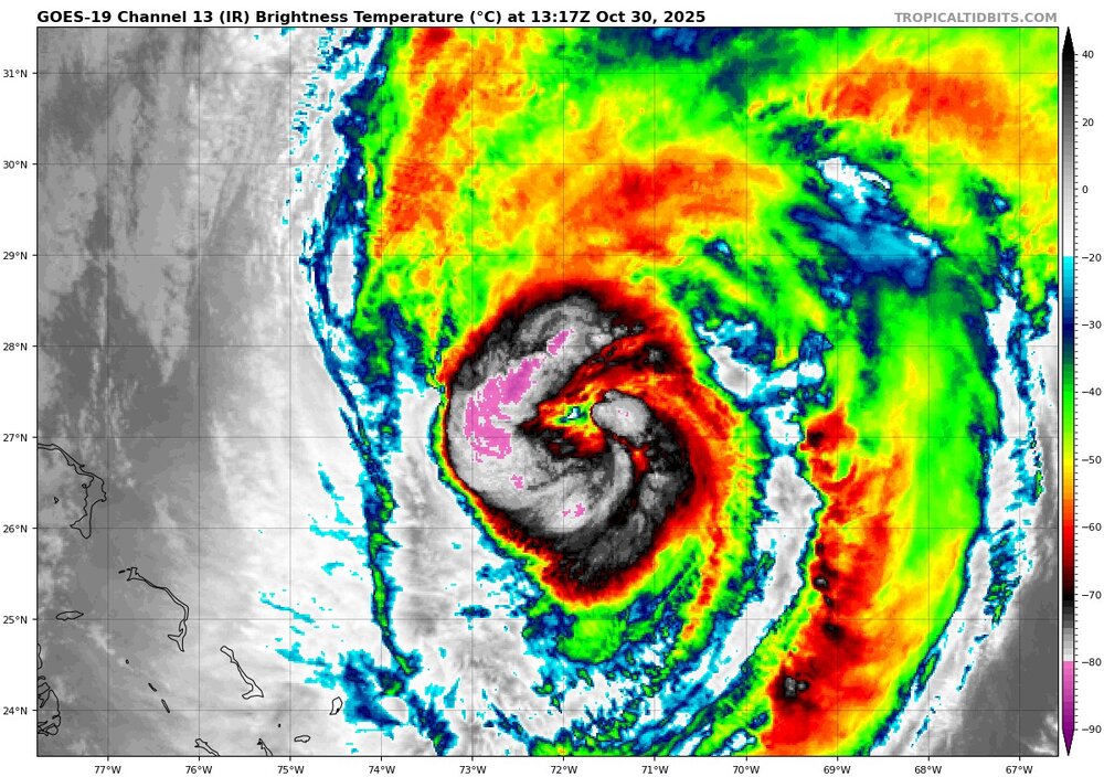
Melissa is starting to expand in size, which is to be expected as it increases in latitude. But is it also starting to interact with the system affecting the northeast US right now as well?
blob:https://www.tropicaltidbits.com/1f3f0d59-f4f3-4f1e-85b0-d28463901100 -
Forward speed really picking up now.
2:00 PM EDT Thu Oct 30
Location: 29.0°N 70.9°W
Moving: NE at 30 mph
Min pressure: 964 mb
Max sustained: 105 mph -
50 minutes ago, NorthHillsWx said:
Looks like the storm might come close to major again. Really getting its act together this morning on both satellite and recon
I am not sure it will, due to the fact that the system, wind field will expand as it moves north, making it harder to get back to major status. Melissa's lowest pressure is 965mb at the moment.
-
1 minute ago, olafminesaw said:
Also, fresh convection trying to rebuild an eye. Just continues it's legendary journey
Trying to rebuild an eye, but it is definitely open to the NE. Looks like shear is inhibiting outflow to the SE quadrant, maybe some dry air being entrained in as well? Starting to really pick up forward speed now as well at 21mph.
8:00 AM EDT Thu Oct 30
Location: 26.8°N 72.7°W
Moving: NNE at 21 mph
Min pressure: 965 mb
Max sustained: 105 mph -
5:00 PM EDT Wed Oct 29
Location: 22.9°N 74.8°W
Moving: NE at 16 mph
Min pressure: 974 mb
Max sustained: 90 mph -
Maybe an eye trying to form again? That little dot of a different color in the center of that pink and purple?
-
1 minute ago, kvegas-wx said:
All I can think about regarding the recovery is mold. Everywhere. Helene was terrible here in the NC mountains with mold remediation needs. But in Jamaica with no power for months and the high heat and humidity, its going to be awful. Lot of folks starting over there. And they should seriously be looking at concrete printed homes. Never a better case study than now.
Lots of homes in Jamaica were already built that way,
-
4 minutes ago, Hotair said:
And add to the fact that this isn’t a large country with thousands of roofing companies willing to travel to a disaster area. The workforce there is limited as are the tools (cranes, materials, etc). Many of those places will not be rebuilt for at least 3 years or longer.
Now also consider that the percentage of homes covered by insurance in Jamaica is roughly under 5%.
Jamaica is a member of the British Commonwealth of Nations. Which means aid will be coming in from all over the world, along with people that will help rebuild the infrastructure, buildings etc.
-
Water vapor loop, shows dry air and shear to Melissa's west, which is also giving it the kick to move to the NE. Its forward speed is up to 16MPH.
blob:https://www.tropicaltidbits.com/d28d79c9-b1dc-4880-a36a-8269bda320bd
-
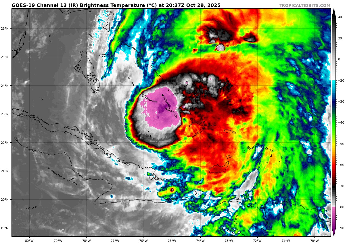
Western semicircle not looking great. Lots of deep convection near the center of circulation.
-
Between Jamaica and Cuba, Melissa got torn apart a bit. Pressure is up to 976, definitely not as healthy as it was yesterday.

-
2
-
-
-
3 minutes ago, WxWatcher007 said:
Center sonde has a 954mb reading with 6kt wind so despite the satellite appearance, it hasn’t translated into strength in a substantial way yet. Obviously still need to see the SW and NE quadrants.
I am not sure the plane got dead center of the hurricane.
https://www.tropicaltidbits.com/recon/recon_AF301-2613A-MELISSA.png
https://www.tropicaltidbits.com/recon/recon_AF301-2613A-MELISSA_dropsondes.png-
1
-
-
11:00 PM EDT Tue Oct 28
Location: 19.3°N 76.6°W
Moving: NE at 9 mph
Min pressure: 950 mb
Max sustained: 130 mph-
1
-
-

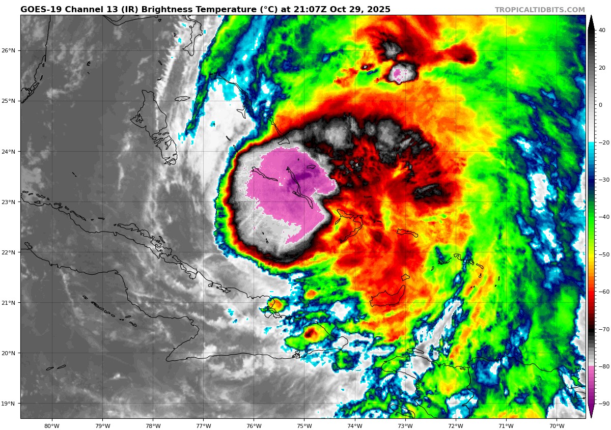
If fhose really intense pink colored convection can wrap completely wrap around the center, will we see it reach cat 5 status again before it hits Cuba? Or will it only make it to Cat 3-4?
-
25 minutes ago, NorthHillsWx said:
Warming near center. Eye about to reappear
18 minutes ago, CoastalWx said:Yeah definitely better looking now.
Looks like the eye will be large than before if this picture is any indication.


December 2025 OBS and Discussion
in New York City Metro
Posted
I don't see anything on the models giving anyone in the tristate area anything more than a possible snow shower or flurry tomorrow.