

Tim from Springfield (IL)
-
Posts
428 -
Joined
-
Last visited
Content Type
Profiles
Blogs
Forums
American Weather
Media Demo
Store
Gallery
Posts posted by Tim from Springfield (IL)
-
-
Nothing right know AFAIK but about an hour or so ago the west part of the ILX CWA, west of Springfield, got some appetizers for tomorrow's event (if anything for our area). There were at least a couple Severe thunderstorm warnings SSW of Jacksonville, IL. If the current cell holds SPI is in play for at least a strong storm in the next hour or so.
Could SPC's 01z outlook extend the marginal farther east into at least Central and Western Illinois?
-
3 hours ago, METALSTORM said:
Would someone smarter than me (which is most) have an analog to compare this possible event to?
Although CIPS's analogs only go back to 1979, could the 12/18/1957 outbreak be a comparable analog to today's threat? That included an F4 in Murphysboro, IL and an F5 in Perry County. However, the bulk of that outbreak was late afternoon and early evening; as opposed to the entirely nocturnal threat tonight (ILX is timing spotter activation for 7PM-3AM tonight and early tomorrow morning.
https://en.wikipedia.org/wiki/Tornado_outbreak_sequence_of_December_18–20,_1957
-
If it's OK, I think tomorrow's severe and heavy rain threats now warrants its own thread. Will be interesting to see this afternoon's Day 2 Update. Wouldn't be surprised if most of MO eventually goes MDT tomorrow.
Overlooked in the midst of tomorrow's ENH for MO and W IL (with hatched TOR possibilities in C/S MO) is that the same areas may get an early start on the severe tonight into early tomorrow. Marginal from Springfield, IL westward for tonight with Slight in the north half of MO into Eastern KS:
https://www.spc.noaa.gov/products/outlook/day1otlk.htmlThreat may continue into Monday for the far eastern portion of the sub. Slight for S OH with marginal extending south and east:
https://www.spc.noaa.gov/products/outlook/day3otlk.html
-
 3
3
-
-
I suggest a separate thread for today's action and tommorrow's ENH/hatched wind right on the 1-year anniversary of 8/10/20.
Tornado with "definite rotation" confirmed near Ohio, IL (north of Princeton):
PRELIMINARY LOCAL STORM REPORT
NATIONAL WEATHER SERVICE QUAD CITIES IA IL
611 PM CDT MON AUG 9 2021

..TIME...   ...EVENT...      ...CITY LOCATION...     ...LAT.LON...
..DATE...   ....MAG....      ..COUNTY LOCATION..ST.. ...SOURCE....
            ..REMARKS..

0603 PM     FUNNEL CLOUD     2 E OHIO                41.56N 89.42W
08/09/2021                   BUREAU             IL   TRAINED SPOTTER

            DEFINITE ROTATION.
-
 1
1
-
-
I would probably recommend that today's ongoing storms and the Tuesday-Wednesday threats be made a separate thread\
Hoping everyone is staying safe tonight
Hard to believe the exact same areas being tonight and under the gun again tomorrow were the same areas hit 1 year ago tomorrow (8/10/20)-
2
-
-
With the Atlantic hurricane season now expected to have at least 25 named storms, and the heat wave earlier this summer in Siberia, is it just me or does anyone else think that COVID-19 (the virus itself and the effects) might actually be altering the weather this year? This article thinks so and is using the early Arctic ice melt as an example:
-
 2
2
-
-
20 hours ago, Hoosier said:
D0 making an appearance in much of Indiana

And another D0 parked directly over St. Louis city and County, and most of St. Charles County, MO. Plus between Detroit and Toledo, and in western IA and western KY. Also a large D1 in Minnesota.
-
Not even a marginal risk in this area and the pulse-type storms are already spawning a mini-severe outbreak in central IL. TOG southwest of Taylorville, IL. Decatur in crosshairs if it continues on its path:
BULLETIN - EAS ACTIVATION REQUESTED Tornado Warning National Weather Service Lincoln IL 615 PM CDT Thu May 28 2020 The National Weather Service in Lincoln has issued a * Tornado Warning for... Southwestern Christian County in central Illinois... * Until 645 PM CDT. * At 614 PM CDT, a confirmed tornado was located near Harvel, or 5 miles southwest of Morrisonville, moving northeast at 25 mph. HAZARD...Damaging tornado and quarter size hail. SOURCE...Weather spotters confirmed tornado. IMPACT...Flying debris will be dangerous to those caught without shelter. Mobile homes will be damaged or destroyed. Damage to roofs, windows, and vehicles will occur. Tree damage is likely. * The tornado will be near... Morrisonville around 625 PM CDT. Other locations impacted by this tornadic thunderstorm include Palmer. -
12 minutes ago, Indystorm said:
Bulk shear and low level lapse rates have improved dramatically over the tor watch area with Violent Tornado Parameter (VTP) up to two just south of Rockford area. Good low level lapse rates will help any horizontal vortex to be lifted into the vertical.
Is it possible that SPC's 2000Z forecast may upgrade a narrow part of the ENH area to either a hatched TOR area, and/or a MDT risk?
If so, I say probably mostly north of I-80 and along/E of IL-26
-
1 minute ago, Indystorm said:
BULLETIN - EAS ACTIVATION REQUESTED
TORNADO WARNING
NATIONAL WEATHER SERVICE LINCOLN IL
409 PM CDT SUN MAY 17 2020
THE NATIONAL WEATHER SERVICE IN LINCOLN HAS ISSUED A
* TORNADO WARNING FOR...
SOUTHEASTERN MACON COUNTY IN CENTRAL ILLINOIS...
* UNTIL 445 PM CDT.
* AT 409 PM CDT, A SEVERE THUNDERSTORM CAPABLE OF PRODUCING A TORNADO
WAS LOCATED OVER MACON, OR 7 MILES SOUTH OF DECATUR, MOVING
NORTHEAST AT 20 MPH.
HAZARD...TORNADO.
SOURCE...RADAR INDICATED ROTATION.
IMPACT...FLYING DEBRIS WILL BE DANGEROUS TO THOSE CAUGHT WITHOUT
SHELTER. MOBILE HOMES WILL BE DAMAGED OR DESTROYED.
DAMAGE TO ROOFS, WINDOWS, AND VEHICLES WILL OCCUR. TREE
DAMAGE IS LIKELY.
* THIS DANGEROUS STORM WILL BE NEAR...
MOUNT ZION AROUND 425 PM CDT.
LONG CREEK AROUND 430 PM CDT.
DECATUR AROUND 435 PM CDT.Severe Thunderstorm Watch just also issued in the last few minutes for Eastern Illinois (roughly along and east of US-51, including Decatur) and Western IN.
-
3 hours ago, snowlover2 said:
End date should likely be changed to the 18th with the eastern sub seeing heavy rain and possible severe tomorrow.
I updated the end date to Tuesday (May 19) since WPC keeps a Marginal Excessive Rainfall risk for SE IN/S OH into Tuesday in its Day 3 outlook:
https://www.wpc.ncep.noaa.gov/qpf/ero.php?opt=curr&day=3-
1
-
-
Severe Thunderstorm Warning south of Jacksonville, IL in northern Greene County. Thunderstorms have been moving into western Illinois (moving NNE) the last few hours. Also some good storms (nothing severe yet) northeast and east of STL.
It wouldn't surprise me if the 2000Z Day 1 extends the Marginal in Iowa to also include parts of MO and possibly most of IL.
BULLETIN - IMMEDIATE BROADCAST REQUESTED
Severe Thunderstorm Warning
National Weather Service St Louis MO
220 PM CDT Sat May 16 2020

The National Weather Service in St Louis has issued a

* Severe Thunderstorm Warning for...
  Northern Greene County in southwestern Illinois...

* Until 300 PM CDT.

* At 220 PM CDT, a severe thunderstorm was located near White Hall,
  moving northeast at 10 mph.

  HAZARD...Quarter size hail.

  SOURCE...Radar indicated.

  IMPACT...Damage to vehicles is expected.

* Locations impacted include...
  White Hall, Carrollton, Roodhouse, Patterson, Hillview,
  Walkersville, Belltown, Berdan, Haypress and Barrow.
-
The latest Day 2 for tomorrow extends the slight back to central OH, and marginal to C/S IN. Also a 5/30/15 Enhanced north of NYC:
https://www.spc.noaa.gov/products/outlook/day2otlk.html
...Northeast States and Ohio Valley regions...

   Shortwave trough now situated over ND near the international border
   will continue into the Great Lakes Friday, reaching the northeast
   states later Friday afternoon and evening. A low amplitude impulse
   may precede this feature. By late afternoon the accompanying cold
   front should extend from a surface low in upstate NY southwest into
   the lower Great Lakes and OH Valley. Warm front will extend from the
   surface low through southern New England. Modest low-level moisture
   with upper 50s to around 60 F dewpoints will advect through the
   pre-frontal warm sector and contribute to 1000-1500 J/kg MLCAPE as
   the surface layer warms during the afternoon. Thunderstorms are
   expected to redevelop along and ahead of the front by early to mid
   afternoon within the weakly capped, destabilizing warm sector. A
   mid-level jet within the base of the approaching shortwave trough
   will contribute to 35-45 kt effective bulk shear over the northeast
   U.S. supporting organized storms including a few supercells and
   bowing segments with damaging wind the main threat. The low-level
   jet is forecast to strengthen by late afternoon into early evening
   across the northeast U.S. with 0-1 km hodographs becoming sufficient
   for isolated tornadoes, especially with any storms interacting with
   the warm front across southern New England. Farther west across OH,
   deep-layer shear will be weaker, but wind profiles with 40-45 kt
   flow in the 700-500 mb layer will be supportive of a few damaging
   wind gusts as the boundary layer destabilizes during the afternoon.
-
I've already started a thread encompassing tomorrow's severe weather (plus in case tonight's marginal in W IL/E IA ramps up) through this weekend's heavy rain threat as the front stalls:
-
Day 2 for tomorrow:
https://www.spc.noaa.gov/products/outlook/day2otlk.html...Eastern Kansas into the Mid Mississippi Valley, Midwest, Ohio Valley, and Lower Great Lakes... Showers and thunderstorms will likely be ongoing Thursday morning in a low-level warm advection regime across parts of the mid MS Valley into the Midwest and lower Great Lakes. A weak mid-level perturbation associated with this convection should continue to shift eastward across these regions through the day. In its wake, a more amplified shortwave trough should progress over the northern Plains to the Upper Midwest by Thursday evening. At the surface, a weak low initially over IA Thursday morning should develop northeastward to lower MI by the early evening, with a warm front lifting northward across much of the Midwest/OH Valley into the lower Great Lakes. A trailing cold front across the mid MS Valley into the central Plains is forecast to make only slow southeastward progress through the period. In the wake of the morning convection, low-level moistening, diurnal heating, and steepening mid-level lapse rates owing to an EML advecting eastward from the Plains will contribute to a destabilizing airmass by Thursday afternoon along/south of both the warm and cold fronts. Instability should be stronger from eastern KS into the mid MS Valley and perhaps IL, where MLCAPE may reach 2000-3000+ J/kg before convective initiation. Storms should form along/near the cold front by mid to late afternoon, with large-scale ascent possibly being aided by another weak mid-level perturbation. The stronger mid-level flow associated with the northern Plains/Upper Midwest shortwave trough may remain generally displaced to the north of the warm sector. Still, there should be enough of a veering/strengthening wind profile through the low/mid levels to support organized storms. Initial convective development along or just south of the front may pose a large hail threat given the steep mid-level lapse rates and marginal effective bulk shear values (around 30-35 kt) supporting occasional supercells. Although low-level flow is not forecast to be particularly strong, a couple tornadoes may also occur with these any semi-discrete storms. The Slight Risk has been expanded slightly northward across MO/IA/IL to account for better model agreement in the placement of the front Thursday afternoon. Damaging winds should become the primary threat with time as storms congeal into multiple east-southeastward moving clusters/bows through the evening. By late Thursday evening/overnight, this activity should weaken as it encounters increasing convective inhibition with southeastward extent across the warm sector. From roughly IN eastward into Lower MI and OH, low-level moisture and diurnal heating will probably remain more limited owing to morning convection. Still, enough instability should develop by late afternoon to pose some large hail/damaging wind threat along and south of the northward-moving warm front. Latest guidance suggests this front will probably extend across southern Lower MI by Thursday evening, with one or more clusters potentially moving eastward along or just south of this boundary. The Slight Risk for damaging winds has been extended eastward across more of northern/central IN, southern Lower MI, and into northwestern OH to account for this threat.
Also Heavy Rain this weekend including in central Illinois. ILX's take:
-
From ChicagoStorm in the general severe thread regarding tomorrow:
"Tomorrow definitely holds potential, but all hinges on tonight/tomorrow mornings activity.
SGT risk looks good for now, but could need upgrade to ENH in the morning once everything becomes clear."
Going to take the bait and start a thread for the upcoming storm system including tomorrow's severe threat. This thread can also be a catch-all for other threats including the heavy rain expected in parts of the sub (especially MO/IL) through Sunday, as the system stalls.
Today's threat far west of the sub but SPC's Day 1 has consistently had a marginal up to along and west of the Illinois River:
https://www.spc.noaa.gov/products/outlook/day1otlk.html -
New Severe Thunderstorm Warning that now includes Springfield and southern Sangamon County:
BULLETIN - IMMEDIATE BROADCAST REQUESTED
Severe Thunderstorm Warning
National Weather Service Lincoln IL
731 PM CDT Sat Apr 11 2020

The National Weather Service in Lincoln has issued a

* Severe Thunderstorm Warning for...
  Northwestern Christian County in central Illinois...
  Southern Sangamon County in central Illinois...

* Until 815 PM CDT.

* At 730 PM CDT, a severe thunderstorm was located near Loami, or 9
  miles north of Virden, moving east at 45 mph.

  HAZARD...Quarter size hail.

  SOURCE...Radar indicated.

  IMPACT...Damage to vehicles is expected.

* Locations impacted include...
  Springfield, Taylorville, Chatham, Auburn, Rochester, Pawnee,
  Kincaid, Divernon, Edinburg, Loami, Bulpitt, Jeisyville, Southern
  View, Thayer, Tovey, Berry, Curran, Sangchris Lake State Park,
  Glenarm and Sharpsburg.

This includes the following highways...
 Interstate 55 between mile markers 77 and 94.
 Interstate 72 between mile markers 94 and 100.
-
More active than expected in Western Illinois today. Hoping that is not a precursor to tomorrow despite currently being in a Marginal Risk in central Illinois.
Severe Thunderstorm Warning now immediately to my west for a rogue warned cell southwest of Jacksonville. If it continues to hold it could clip the south side of Springfield in about an hour:
BULLETIN - IMMEDIATE BROADCAST REQUESTED
Severe Thunderstorm Warning
National Weather Service Lincoln IL
657 PM CDT Sat Apr 11 2020

The National Weather Service in Lincoln has issued a

* Severe Thunderstorm Warning for...
  Southeastern Scott County in west central Illinois...
  Southwestern Sangamon County in central Illinois...
  Southeastern Morgan County in west central Illinois...

* Until 745 PM CDT.

* At 656 PM CDT, a severe thunderstorm was located near Murrayville,
  or 7 miles east of Winchester, moving east at 40 mph.

  HAZARD...Quarter size hail.

  SOURCE...Radar indicated.

  IMPACT...Damage to vehicles is expected.

* Locations impacted include...
  Jacksonville, Alexander, New Berlin, Waverly, Loami, Franklin,
  Murrayville, Woodson, South Jacksonville, Thayer, Berlin,
  Lynnville, Nortonville, Lowder and Lake Jacksonville.

This includes Interstate 72 between mile markers 57 and 69, and
between mile markers 75 and 89.
-
Now a SVR warned cell in far western Illinois, on track to affect areas between Macomb and Monmouth:
Severe Thunderstorm Warning
ILC067-071-109-187-112315-
/O.NEW.KDVN.SV.W.0037.200411T2225Z-200411T2315Z/

BULLETIN - IMMEDIATE BROADCAST REQUESTED
Severe Thunderstorm Warning
National Weather Service Quad Cities IA/IL
525 PM CDT Sat Apr 11 2020

The National Weather Service in the Quad Cities has issued a

* Severe Thunderstorm Warning for...
  Northeastern Hancock County in west central Illinois...
  Southern Henderson County in west central Illinois...
  Southern Warren County in west central Illinois...
  Northern McDonough County in west central Illinois...

* Until 615 PM CDT.

* At 524 PM CDT, a severe thunderstorm was located near Disco, or 12
  miles north of Carthage, moving east at 50 mph.

  HAZARD...Quarter size hail.

  SOURCE...Radar indicated.

  IMPACT...Damage to vehicles is expected.

* Locations impacted include...
  Bushnell, La Harpe, Roseville, Dallas City, Blandinsville, Good
  Hope, Prairie City, Terre Haute, Raritan, Sciota, Colusa, Adrian,
  Little Swan Lake, Disco, Walnut Grove, Greenbush, Lomax,
  Scottsburg, Warren County Fairgrounds and Swan Creek.
-
5 hours ago, Hoosier said:
That is a bad situation shaping up for them, especially in the midst of the pandemic. The worse the tornadoes are, the more likely that shelters will be needed for people who lose their homes. Shelters = groups of people
Very true. And we've had two close calls here already (Mar. 28 and Apr. 8).
Plus MO/IL/IN/OH still very much in play for at least scattered strong/severe storms on Easter Sunday.
LSX's AFD this afternoon is thinking that SPC needs to move the Marginal Risk farther north in their Day 2 outlook. If this happens, PIA and maybe Detroit and Chicago could be in play for strong/severe on Sunday:
https://forecast.weather.gov/product.php?site=LSX&issuedby=LSX&product=AFD&format=CI&version=1&glossary=1This combination of factors will almost certainly bring widespread showers to the region on Sunday, and it looks like we`ll have sufficient instability to support at least embedded thunderstorms. Moreover, given strong system dynamics, a few strong to severe storms are possible. Given these parameters, I think SPC`s marginal risk is probably appropriate, though it may need to be pulled a bit farther north what is shown in the the current day 3 outlook.
-
On the southern part of this system, SPC already has a Day 3 MDT and 45% hatched severe probs for parts of SE AR, Louisiana, MS, and AL on Easter Sunday. Very rare to see 45% probs on a Day 3, so Easter might be sadly a historic tornado/severe day in Dixie Alley.
Slight risk currently includes far SE IL and SW IN. Marginal is currently roughly along and south of a COU-SPI-CMI-FWA-PKB line in this subforum.
https://www.spc.noaa.gov/products/outlook/day3otlk.html
...Mid MS Valley into the OH Valley...
   Destabilization in the vicinity of the primary surface low into the
   mid MS Valley/OH Valley is more uncertain, given the potential for
   disruptive convection further south. However, favorable wind
   profiles and closer proximity to the ejecting shortwave will support
   some severe thunderstorm threat in this region as well, with a
   conditional risk of all hazards given sufficient destabilization.
-
Huge Day 2 update for tomorrow. Slight risk basically extended along/south of I-74 in Illinois--and a hatched for large hail (albeit still 2/15/15 probs at this time). Maybe at least an enhanced from NE MO/W IL to SE MO tomorrow.
https://www.spc.noaa.gov/products/outlook/day2otlk.htmlDay 2 Convective Outlook NWS Storm Prediction Center Norman OK 1236 PM CDT Tue Apr 07 2020 Valid 081200Z - 091200Z ...THERE IS A SLIGHT RISK OF SEVERE THUNDERSTORMS ACROSS MUCH OF THE MID MS VALLEY AND OVER PORTIONS OF CENTRAL TX... ...SUMMARY... Scattered strong to severe thunderstorms are possible over parts of central Texas Wednesday afternoon and the Middle Mississippi Valley on Wednesday evening and overnight. Large hail, damaging gusts, and perhaps a couple of tornadoes are the primary hazard. ...Synopsis... A split-flow pattern is forecast to be in place across the CONUS early Wednesday morning. Primary features within this pattern will be a northern-stream shortwave trough, which is expected to progress southeastward through the northern Plain and Mid/Upper MS Valley, and a southern-stream closed low, which is expected to slowly drift eastward over southern CA. More pertinent to the severe weather threat, a low-amplitude shortwave trough is expected to progress through the southern-stream over the southern Plains and Lower MS Valley. Confluence of the two streams will occur over the MS River Valley, with relatively strong flow aloft persisting, and then increasing late in the period, over the eastern CONUS. Primary feature within the surface pattern will be a cold front that is expected to surge southeastward from the northern Plains/upper MS Valley into the central Plains/mid MS Valley by Wednesday evening, continuing eastward/southeastward through the southern Plains, Mid-South, and TN/OH Valleys by Thursday morning. Moist southwesterly low-level flow will advect high theta-e air into the mid MS Valley ahead of this front while maintaining the moist air mass already in place from east TX through the Southeast. ...Mid MS Valley into portions of the OH/TN Valleys... A somewhat broad area of Slight-risk equivalent severe weather probabilities will exist over much of the region Wednesday. This is due to different model depictions of low-level moisture return, cap strength, and frontal timing as well as at least some modest risk for pre-frontal development. The general expectation is for thunderstorms to initialize along the front during the afternoon and then push southeastward throughout the evening. Initial storm mode will likely be cellular, with the thermodynamic and kinematic profiles supporting the threat for very large hail. Given the linear forcing, a quick linear transition is anticipated, with the severe threat also transitioning from hail to damaging wind gusts. Tornado threat will be non-zero, but relatively weak and veered low-level flow suggests low potential for development. The overall threat appears highest across northeast MO and adjacent western IL southeastward into southern IL and southeast MO although not high enough to delineate higher probabilities with this outlook. An upgrade may be needed in subsequent outlooks if a corridor of higher risk appears more likely. A more conditional severe threat exists south in AR, where frontal timing will be less favorable but more moist low-level conditions will exist. Any storm within this environment would likely be severe. ...TX Hill Country/Central TX... Low-amplitude, southern-stream shortwave trough mentioned in the synopsis will likely provide enough ascent to foster thunderstorm initiation over the region during the afternoon. Thermodynamic environment will be characterized by ample low-level moisture (i.e. dewpoints in the upper 60s/low 70s) beneath steep mid-level lapse rates. Resulting strong buoyancy coupled with deep-layer shear around 40-50 kt should be more than supportive for organized storm structures. Initial threat will be large hail, with some instances of very large hail possible. The initially cellular mode will likely transition more linear quickly, with the primary threat then transitioning to damaging downburst winds resulting from water-loaded downdrafts. An initial supercell mode will also result in a low-probability threat for an isolated tornado, although low-level winds do not appear overly favorable for low-level rotation. ...Southeast into the Mid-Atlantic... Residual boundaries from antecedent showers and thunderstorms will likely act as an impetus for additional convective initiation Wednesday afternoon. Relatively deep and strong northwesterly flow aloft would likely support organized storm structures and an attendant severe weather threat. Mesoscale nature of this threat precludes any corridors of higher potential on this outlook, but updgrades may be needed in following outlooks once mesoscale features become more predictable. ..Mosier.. 04/07/2020
-
I took the plunge and started a thread for tonight thru Wednesday's possible severe action in parts of the sub:
-
Far southern portions of the sub, including PAH, Evansville and Louisville, also in play for severe on Wednesday:
https://www.spc.noaa.gov/products/outlook/day3otlk.html
 ...Mid MS Valley into parts of the OH/TN Valleys...
   Models are showing a plume of steep 700-500mb lapse rates extending
   from the central Great Plains eastward into the lower OH Valley
   ahead of the amplifying upper trough.  This model guidance indicates
   a residual moisture reservoir (featuring 60s F dewpoints), located
   over the lower MS Valley and TN Valley, will contribute to moderate
   destabilization.  Frontal forcing will seemingly focus storm
   development during the late afternoon/early evening over the mid MS
   Valley region.  Strong mid- to high-level westerly flow will favor
   organized storms.  As convective coverage increases during the
   evening, a squall line with an accompanying risk for damaging gusts
   will move east-southeast with the threat probably extending through
   the evening and into the overnight hours.

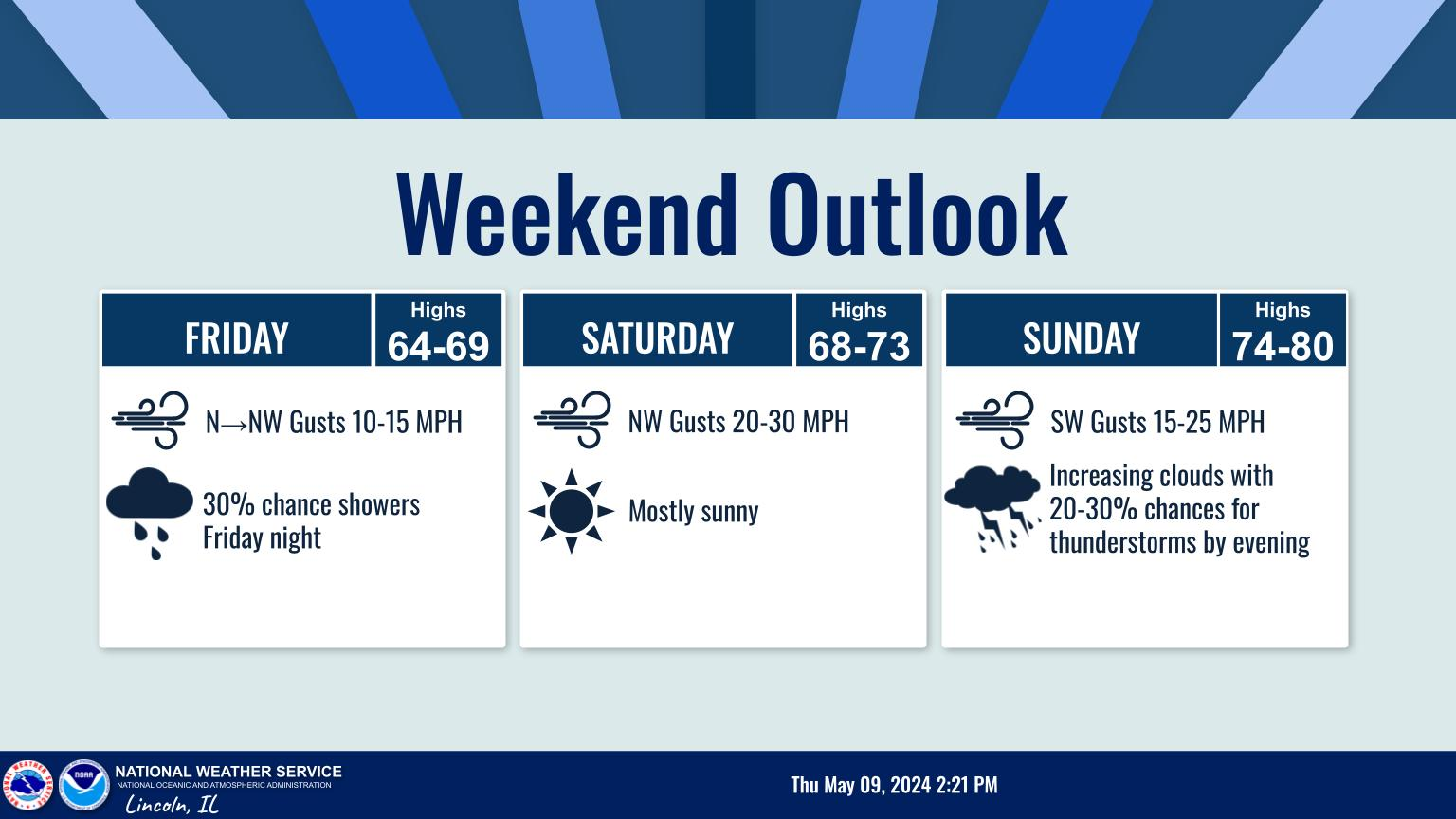
February 2024 General Discussion
in Lakes/Ohio Valley
Posted
Just saw in today's St. Louis Post Dispatch that Fox 2 in STL is predicting 80 degrees for high in the St. Louis area on Tuesday.
I am going to go on a limb and predict that at least one point in the immediate St. Louis area will not only surpass 80 on Tuesday, but have at least a 90 degree heat index for a time as well. On Feb. 27.