-
Posts
2,878 -
Joined
-
Last visited
Content Type
Profiles
Blogs
Forums
American Weather
Media Demo
Store
Gallery
Posts posted by north pgh
-
-
I hit 29 this morning at 7:00 am. Lots of frost.
-
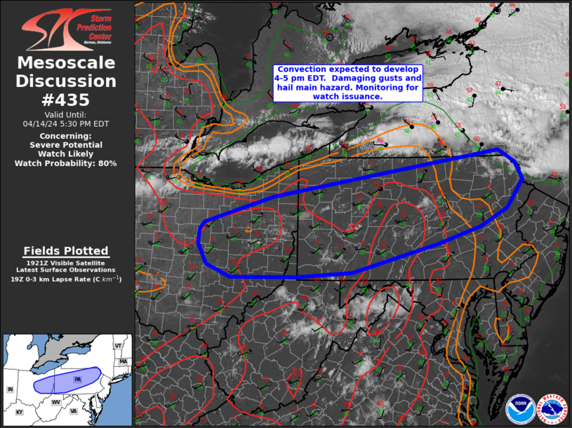
Gusted to over 50 mph here. Did not lose power however I heard some transformers blowing in the distance. Some lightning and thunder now after the line has gone through but the pre frontal winds were the worst. Sounds like power lines are down in the area. Pretty calm now.
-
1 minute ago, RitualOfTheTrout said:
Looks like a good call. Mother natures firework show lighting up the sky right now.
I’m out on my deck watching. Beautiful show and nice summer breeze.
-
Storms still back building a bit into Ohio and slowly shifting south. I think we will still get some of this moving in after 10:00. Probably not severe though.
A nice light show going on to our north
-
-
Flood Watch National Weather Service Pittsburgh PA 148 PM EDT Mon Apr 1 2024 OHZ039-040-048>050-PAZ021-029-073-074-WVZ001>003-020345- /O.EXA.KPBZ.FA.A.0003.000000T0000Z-240403T0000Z/ /00000.0.ER.000000T0000Z.000000T0000Z.000000T0000Z.OO/ Tuscarawas-Carroll-Coshocton-Harrison-Jefferson OH-Allegheny- Washington-Westmoreland-Higher Elevations of Westmoreland-Hancock- Brooke-Ohio- Including the cities of Canonsburg, Monessen, Lower Burrell, Malvern, Ligonier, Carrollton, Washington, Steubenville, Donegal, Murrysville, Weirton, Dover, Greensburg, Wellsburg, Coshocton, New Philadelphia, Wheeling, Follansbee, New Kensington, Latrobe, Pittsburgh Metro Area, and Cadiz 148 PM EDT Mon Apr 1 2024 ...FLOOD WATCH IN EFFECT THROUGH TUESDAY EVENING... * WHAT...Flooding caused by excessive rainfall continues to be possible. * WHERE...Portions of east central Ohio, including the following areas, Carroll, Coshocton, Harrison, Jefferson OH and Tuscarawas, Pennsylvania, including the following areas, Allegheny, Higher Elevations of Westmoreland, Washington and Westmoreland, and West Virginia, including the following areas, Brooke, Hancock and Ohio. * WHEN...Through Tuesday evening. * IMPACTS...Excessive runoff may result in flooding of rivers, creeks, streams, and other low-lying and flood-prone locations. Creeks and streams may rise out of their banks. Flooding may occur in poor drainage and urban areas. * ADDITIONAL DETAILS... - Multiple rounds of showers and thunderstorms are expected through Tuesday evening. Each will have the potential to produce heavy rain, with a cumulative effect evolving to create increasing potential for excessive runoff with each successive round. Total rainfall estimates through Tuesday evening will likely reach 1 to 2 inches across the Watch area, with locally higher amounts up to 3 inches possible. - http://www.weather.gov/safety/flood PRECAUTIONARY/PREPAREDNESS ACTIONS... People in the watch area, especially those living in areas prone to flooding, should be prepared to take action should flooding develop. Monitor the latest forecasts and be alert for possible flood warnings. && -
14 hours ago, CoraopolisWx said:
Based on records I could find, this could end up being the lowest two year snowfall total anyone alive today has ever experienced. (Anyone alive back in 1932 would likely have been very young)
This can only mean we are due big time for Winter 2024-2025

-
 1
1
-
-
Lines of storms split and went right around central Allegheny County
-
16 minutes ago, RitualOfTheTrout said:
Fun day tracking squalls. Got hit several times, drove through a near whiteout around 430.
Moderate snow again now, winds ripping aswell. Now that its dark starting to get some accumulation even on the road. Maybe close to half an inch since sunset.
My thoughts exactly. Sometimes these days are like tracking thunderstorms in the summer.
-
Am I the only one looking forward to a few snow squalls tomorrow?

-
 2
2
-
-
Looking like we may get some snow on Sunday. Snow showers at least and Canadian is showing some possible streamers putting down an inch or so. (I know it won't stick long but will be nice to see some snow in the air and maybe in the grassy areas) Will have to watch it closely. Then it warms back up early next week. Too much rain lately my yard has been soggy. More rain to come tomorrow night and Saturday.

-
We’ve had more lightning strikes this morning than we had inches of snow this winter.
-
 1
1
-
-
I just drove from Bakerstown down to Ross. I went through a bunch of pop up cells. No hail in my drive but heavy downpours and lightning strikes in 3 of the storms. If we can't get the snow I'll take the thunderstorms.

-
-
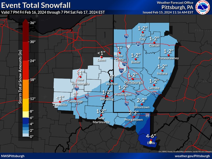
4.25 here. Still snowing lightly. Another small batch in central Allegheny County about to come through. Could put me to 5. This made up for last week and came while we were awake. Nice!
-
3 inches just measured here.
-
About an inch of the fluffy stuff.
-
Remember that this snow is mostly going to fall over a 6 hour or so period so to even get 2-4 inches it will snow at least 1/2 inch an hour which is pretty good rates. Even an inch an hour in some cases.

-
 3
3
-
-
NAM is North
-
Wind is really howling out there. Rain about to blow through.
As far as tomorrow I trust the Canadian after how it scored the last one. I think 1-2 is a solid bet tomorrow night.
-
-
7 minutes ago, Rd9108 said:
HECS or bust at this point. Not really interested in a 3-6 storm that melts by midday. I should have no excuses for my golf game with this weather.
Don't get me wrong, I will take a 1-3 storm anytime during the day but if it happens while I'm asleep then to me it's no fun shoveling it if you can't see it falling.
-
This storm is moving so fast we probably wouldn't even see a flake fall unless you were awake at 4:00 am. I'll drive to my meeting tomorrow morning with a few flakes in the air and bare wet ground and take it. On to the next week. No biggie.
-
2 minutes ago, KPITSnow said:
But man we are cursed here. We went from being 50 miles too far south to 50-100 miles too far north in like 3 runs
Yes these models are ridiculous.
-
 1
1
-


Pittsburgh/Western PA Spring 2024
in Upstate New York/Pennsylvania
Posted