

anthonyweather
-
Posts
1,663 -
Joined
-
Last visited
Content Type
Profiles
Blogs
Forums
American Weather
Media Demo
Store
Gallery
Posts posted by anthonyweather
-
-
The HRRR has held steady in its past few runs instead of continuing to trend south. Latest run has 6-9” for most of us with snow still falling everywhere.
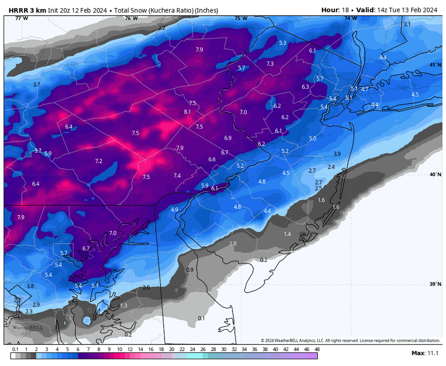
Rap also kicked north a bit fwiw.
. -
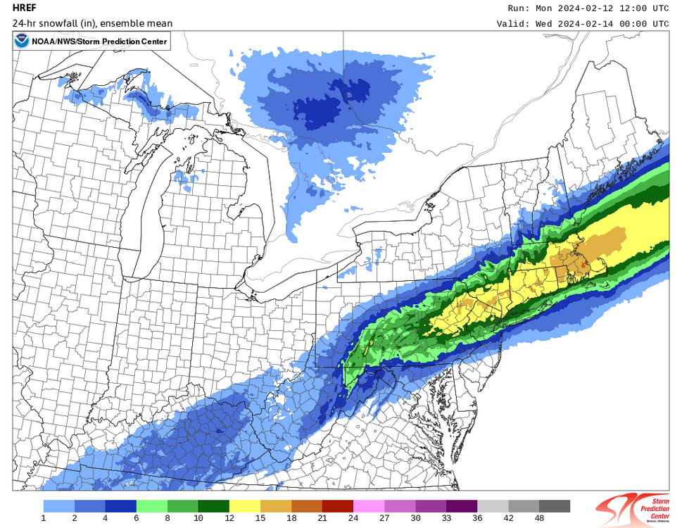
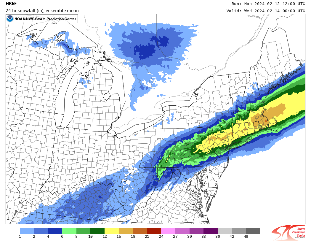
So I know the NWS relies heavily on the HREF. So here is the latest HREF.. Maybe why they arent changing their forecast? Only thing I can think of

-
 1
1
-
-
This is a real nailbiter Jesus. Gonna have to live and die with the radar I suppose

.-
1
-
-
Man 3/4 of PA is in for a rude awakening

.-
1
-
-
If the NAM comes as far south as the RAP then it’s time to start worrying a little. This thing isn’t gonna miss us like it might in Scranton, but another sizable shift south leaves us with 2-4” or 3-6” instead of 6-10”+.
Yeah just concerning that hrrr and rap made significant jumps south after the euro
. -
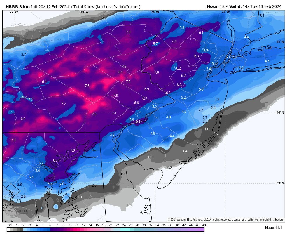
Zoomed in HRRR. I think the entire subforum would be happy with this!
I retract my statement, but rap is further s then this
.-
 1
1
-
-
Unless the mesos go way SE I’m not putting any stock in the Euro at all. Under 24 hours it’s typically better to look at mesos than globals.
RAP and HRRR just did. Ugh. Were even slowly losing this one up here
. -
Latest Srefs. I would think the Nams hold in light of these.
(8).thumb.png.ab984a2a7c6a9d3bdb6d3998db23639d.png)
These follow the previous NAM, not suggestive of the new NAM
. -
Insane shift on GFS and euro. Has to bump a touch N at 12z right?!
.
I would think euro will bump north some. But N&w burbs should do well with 3-6/4-8 & LV 6-12 & poconos 9-16
. -
You’re increasing totals? I think I’ll go up to 4-8” if/when I do…low ratios and BL issues scare me. Only way we get to 10” is if we have an earlier changeover and get under that death band for 3+ hours.
That band is capable of 2-3” per hour, and it’s not a small Norlun trough type feature. She’s wide
. -
Hoping like hell I wake up to this trend having stuck and a Winter Storm Warning for Bethlehem
I’m pretty certain that’s why they held onto the watch, but upgraded the Poconos. So you can bet your bottom dollar there will be a winter storm warning when you wake up tomorrow.
. -
You’re increasing totals? I think I’ll go up to 4-8” if/when I do…low ratios and BL issues scare me. Only way we get to 10” is if we have an earlier changeover and get under that death band for 3+ hours.
Yeah I’ll reassess in the morning but likely 4-8/5-9/6-10. See how euro looks and 6z mesos and go from there
. -
-
NAM big step back compared to 18z run.
Depends on location. Big increase for Lehigh Valley.
. -
The NAM showed total positive snow depth accumulations meeting or exceeding warning criteria for the LV first the time in several years in tonight's run This is a promising trend that the winter storm watch may be upgraded to an actual warning before the snow event even actually occurs and not during the event . That has not happened in 2-3 years. To me, that is what I have been waiting for this entire year. Once that warning is issued- it can snow a foot or more- I really do not care about being too specific on totals. I think many of us are waiting for the magical warning to be issued too. We have all waited way too long.

It’ll be coming. 6-10”
. -

Still thinking that 8-14 has the opportunity to slide south maybe 20-30 miles-
1
-
-
This one is not our storm. We will be lucky to hit 2”. Our friends to the south are hitting the jackpot.
.
Yup, I forecasted 1-2” the last 2 days…
. -
Man I hope they are on to something
Really perplexing.
Nothing supports it. Nothing. I know the IVT is still 100% up in the air no matter what these models show, but still. Don’t get it
. -

Mt holly yet again increased the Lehigh valley.
I don’t get it lol
. -
18z icon.
Looking like 1-2” area wide but what do I know
. -
I’m in the direct bullseye. 5 to 6 expectation set.
You should really join the NWS if you know where an IVT sets up 18 hours before a storm. You could save a lot of lives
.-
3
-
 2
2
-
-
Yeah next week when it grows spring like this will be long forgotten
I mean, 2-3” will be the norm, if a 4” lollipop makes the phillly crew feel like they got a foot, good for them
.-
1
-
-
Were losing this inch by inch
It’s literally the difference of 1-1.5” lol
.-
2
-
-
18z NAM continues the inching south
3k is significantly further north then 12z.
.-
 1
1
-
(8).png.a1cdc6a1a644cec0021f56dea7c5fc74.png)

2/13 rain to snow event
in Philadelphia Region
Posted
.