
Srain
-
Posts
7,532 -
Joined
-
Last visited
Content Type
Profiles
Blogs
Forums
American Weather
Media Demo
Store
Gallery
Posts posted by Srain
-
-
Out of curiosity, has anyone heard from Doug Heady, aka Joplinmet? He hasn't been on here since April...
I saw reports that he was on duty at the station, providing imformation throughout the event.
-
Good to see you back and posting like 'old times', JoMo. We wish you and yours the very best.
-
I'm ok. My family is ok. We just got power and phone service restored. 3 blocks away is completely gone though. I'll post a more detailed account once I check in with everyone.
Great news! We know it's been one heck of a ride and are glad you are OK!
-
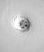
Looking at Piotrowski's video, at times you can hardly tell it's a tornado but a huge mass of boiling black clouds. Move this with a forward speed of 69 mph and you have some idea of what the people in 1925 must have seen. Incidentally, a 20 minute leadtime is excellent for a mesoscale event of only 9 minute's or so duration.
Steve
Strongly agree.
-
I hate to ask, but any word on JoMo yet?
None at this time.
-
Whether it's a tornado warning or emergency...people should take cover. I don't see how you can justify not needing to take cover..just because it's not a tornado emergency. That decision logic is flawed...just take cover.....period.
Bingo!
We beat this same issue to death with the April events. Warnings are warnings, period!
-
I was not following this right as it happened, and can someone verify if Joplin had just a tornado warning, or if a tornado emergency was issued? I went through the Central Forum thread and do not remember seeing any tornado emergency?
The cell was warned and sirens were sounded.
-
-
Memories of the (1953) Waco, TX tornado come to mind as well. Thoughts continue for JoMo and all those in the path.
-
CNN reports debris from St. John's Hospital in Joplin found 70 miles away...
Residents 70 miles away from Joplin in Dade County were finding X-rays from St. John's in their driveways, said Foreman, indicating the size and power of the twister.http://www.cnn.com/2011/US/05/22/severe.weather/index.html?hpt=T1&iref=BN1
-
JoMo is one of the core members from the old Western sub forum on Eastern. Our thoughts are with those in Joplin tonight.
-
-
I'm amazed at the hostility toward a suggestion of simple building standards.
In CA it is simply an expectation-- and guess what? When our metroplex of 8 million had a direct hit by a quake that produced whopping Level IX shaking right in the city, only 75 people died-- out of 8 million. Strict CA building codes saved thousands of lives.
I'm seriously laughing. Miami/Dade building codes that were put in place after Andrew certainly proved worthy for me and my old home in the Keys (adopted Miami/Dade codes in Monroe County) that was built 1999. I had $42.00 damage from Wilma while neighbors in 'older homes' lived in FEMA trailors for month afterwards.
-
CNN/FOX spending most of their time on the Royal wedding with only blips about the tornadoes
I will say that TWC did a great job yesterday (I had not watched their programming in my years). The Bryan Norcross/Greg Forbes team were very informative and hopefully this positive trend will continue from that organization.
-
It’s not very often in the world of weather that we have a chance to witness such extreme meteorological events. It has been amazing to see the parameters and data we saw day after day come to fruition. Hopefully more lives were saved with the advanced warnings of the day. Regardless of the standing, (i.e. Super Outbreak/74) this will rank as one of the more destructive and deadly multi day events of modern US history. My thoughts are with all that have suffered from this event.
-
-
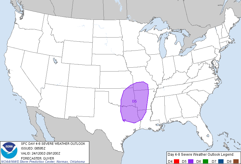
DAY 4-8 CONVECTIVE OUTLOOK
NWS STORM PREDICTION CENTER NORMAN OK
0359 AM CDT THU APR 21 2011
VALID 241200Z - 291200Z
...DISCUSSION...
WHILE SOME DETAILS VARY...THE 00Z ECMWF/GEFS/UKMET ARE IN AMPLE
GENERAL AGREEMENT WITH THE EXPECTED AMPLIFICATION OF THE LARGE SCALE
PATTERN LATE THIS WEEKEND/EARLY NEXT WEEK...HIGHLIGHTED BY A
PROMINENT WESTERN/CENTRAL CONUS UPPER TROUGH.
ON DAY 4/SUNDAY...THE SOUTHERN HIGH PLAINS WILL LIKELY BE A FOCUS
FOR AT LEAST SOME SURFACE BASED SEVERE THREAT NEAR/EAST OF A DRYLINE
ACROSS WEST TX AND PERHAPS INTO OK. OTHER ELEVATED STORMS CAPABLE OF
SEVERE HAIL ARE PROBABLE SUNDAY NIGHT FROM OK INTO THE OZARKS/LOWER
MO VALLEY. BUT GIVEN LINGERING UNCERTAINTY REGARDING THE EXTENT OF
PRE-DARK SURFACE BASED DEEP CONVECTION...LARGELY OWING TO
ANTICIPATED MODEST LARGE SCALE FORCING FOR ASCENT/ONLY WEAK HEIGHT
FALLS...TOO MUCH UNCERTAINTY CURRENTLY EXISTS TO DELINEATE A 30
PERCENT EQUIVALENT SEVERE RISK AREA.
FOR DAY 5/MONDAY...HAVE INTRODUCED A SEVERE RISK AREA FOR PORTIONS
OF THE SOUTHERN PLAINS TO THE ARKLATEX/OZARKS. WHILE TIMING/SPATIAL
DETAILS VARY TO A DEGREE...REASONABLE CONFIDENCE EXISTS THAT A
SOUTHERN STREAM SHORTWAVE TROUGH WILL OVERSPREAD A MOIST AIRMASS TO
THE EAST OF THE DRYLINE/COLD FRONT. AS SUCH...SEVERE STORMS SEEM
LIKELY MONDAY/MONDAY NIGHT ACROSS THIS REGION.
INTO DAYS 6/7 TUESDAY/WEDNESDAY...AS THE NEXT PORTION OF THE CENTRAL
CONUS UPPER TROUGH PIVOTS EASTWARD...A RELATIVELY
WIDESPREAD/MULTI-ROUND SEVERE THREAT IS EXPECTED FROM THE SOUTHERN
PLAINS EAST-NORTHEASTWARD INTO THE MIDWEST AND LOWER/MIDDLE MS RIVER
VALLEY. WHILE SEVERE STORMS SEEM LIKELY EACH OF THESE
DAYS...SPECIFIC PREDICTABILITY IS STILL QUITE LIMITED IN THIS TIME
FRAME.
..GUYER.. 04/21/2011
-


Alaska/Western Canada obs and discussion
in Central/Western States
Posted