
JonClaw
-
Posts
793 -
Joined
-
Last visited
Content Type
Profiles
Blogs
Forums
American Weather
Media Demo
Store
Gallery
Everything posted by JonClaw
-
I guess people memory-holed Cuomo banning travel during 2016's Blizzard.
-
Travel ban in NYC 9PM to Noon tomorrow.
-
Mamdani Presser at 12 if anyone is interested:
-
First flakes in Elmhurst!
-
Seeing this, I'm not concerned yet.
-
Inside baseball: NYC will be closing schools. No remote day.
-
Travel ban shouldn't be far behind now.
-
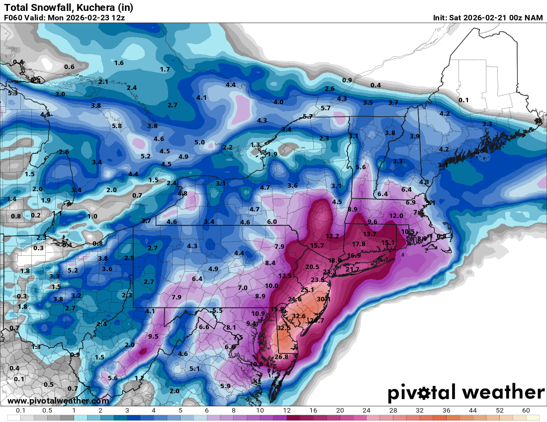
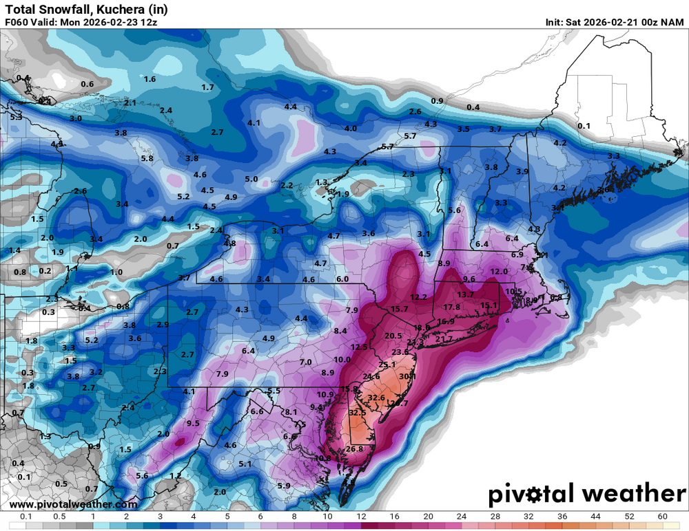
URGENT - WINTER WEATHER MESSAGE National Weather Service New York NY 102 PM EST Sat Feb 21 2026 CTZ009>012-NYZ071>075-078>081-176>179-220800- /O.EXT.KOKX.BZ.W.0001.260222T1800Z-260223T2300Z/ Southern Fairfield-Southern New Haven-Southern Middlesex-Southern New London-Southern Westchester-New York (Manhattan)-Bronx- Richmond (Staten Island)-Kings (Brooklyn)-Northwest Suffolk- Northeast Suffolk-Southwest Suffolk-Southeast Suffolk-Northern Queens-Northern Nassau-Southern Queens-Southern Nassau- 102 PM EST Sat Feb 21 2026 ...BLIZZARD WARNING NOW IN EFFECT FROM 1 PM SUNDAY TO 6 PM EST MONDAY... * WHAT...Blizzard conditions expected. Total snow accumulations between 15 and 20 inches, highest amounts across Long Island. Winds gusting as high as 55 mph with isolated gusts up to 60 mph. Gusts on the east end of Long Island could reach 65 mph. * WHERE...Portions of southern Connecticut and southeast New York. * WHEN...From 1 PM Sunday to 6 PM EST Monday. * IMPACTS...Visibilities may drop below 1/4 mile due to falling and blowing snow. Whiteout conditions are expected and will make travel treacherous and potentially life-threatening. The strong winds and weight of snow on tree limbs may down power lines and could cause sporadic power outages. Travel could be very difficult to impossible. Areas of blowing snow could significantly reduce visibility. The hazardous conditions will impact the Monday morning and evening commutes. * ADDITIONAL DETAILS...Strongest winds are expected Sunday evening through Monday afternoon.
-
NYC Travel Ban incoming per my wife who works in EM.
-
I see Upton has blessed the title of this thread. Excellent
-
What a beauty.
-
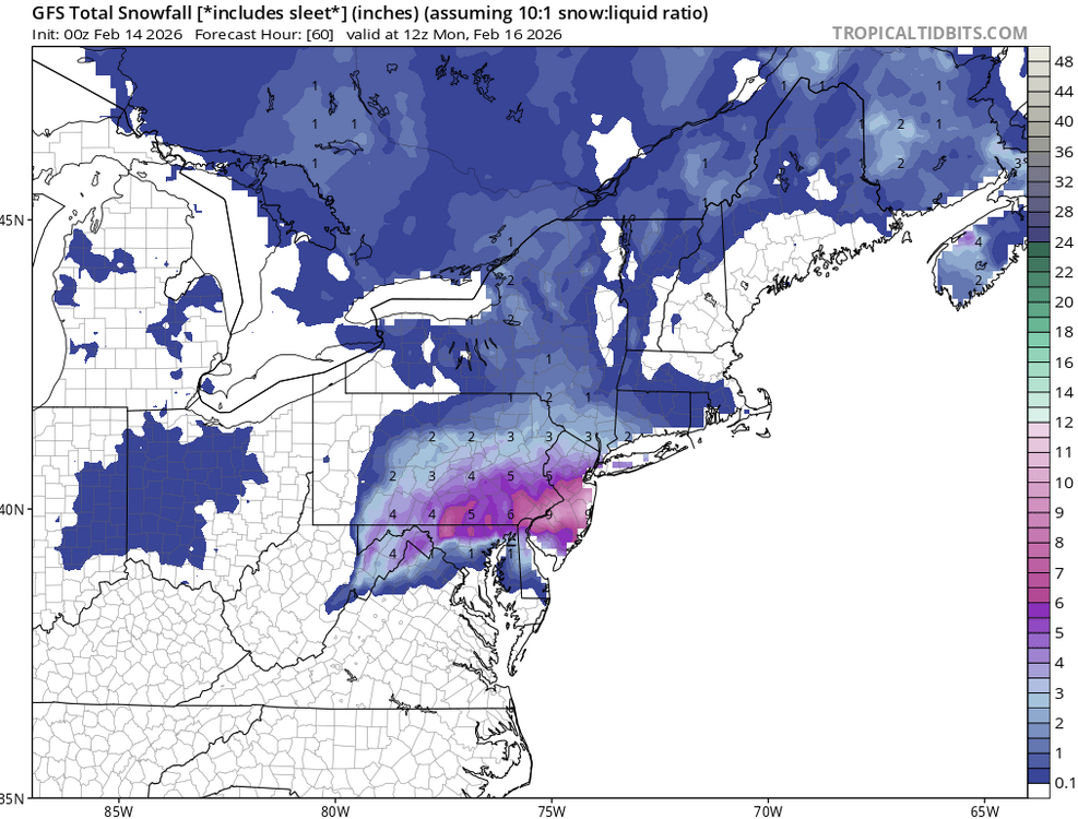
GFS brought the eggs. Just need the Euro to go ham and we've got an omelette!
-
I think we're in for a long Friday night.
-
Verbatim the trend of years ending in 6 having a monster would continue.
-
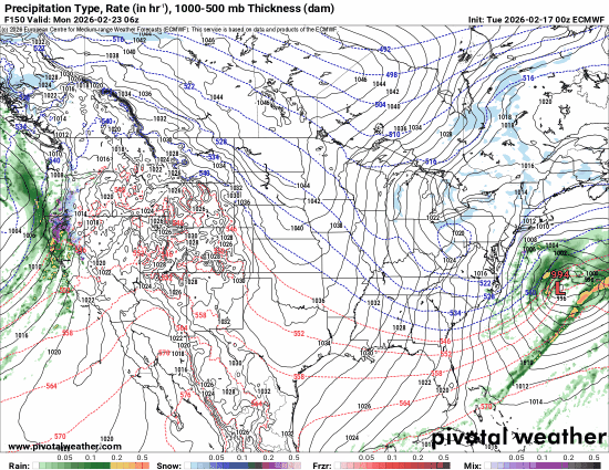
2" QPF @ 60 for NYC... still going...
-
1.23" QPF @ 54 for NYC and still going
-
Love it or hate it, I can't deny betting on Kalshi about how much snow will fall at CP has made me some serious guitar gear money.
-
Last 12 Euro runs:
-
If I could I'd take this GFS, run with it, protect it, nurture it... Here's hoping the Euro agrees.
-
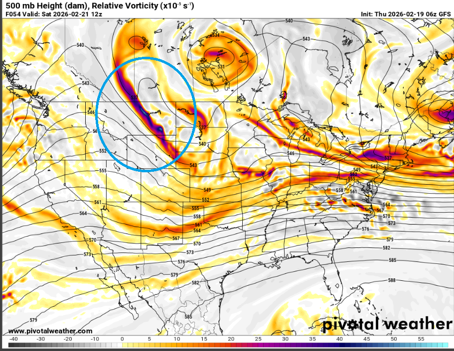
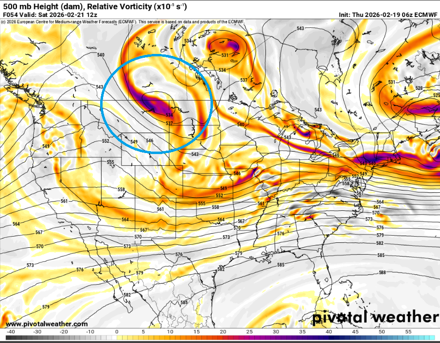
Euro stopped closing off that damn Canadian vort this run!
-
Good trends overnight. Remains to be seen if the GFS caves to the Euro or vice versa. The biggest difference between the two that I see is that piece of energy in Canada at 500mb. On the GFS, it dives down. On the Euro, it stays closed off which messes up the timing. Someone who knows way more than me can provide a better explanation of what's going on here.
-
Dusting on dirt, struggling to stick on sidewalks IMBY
-
00z GFS is a nice hit