

HinghamBoss
-
Posts
381 -
Joined
Content Type
Profiles
Blogs
Forums
American Weather
Media Demo
Store
Gallery
Posts posted by HinghamBoss
-
-
I'm curious to see which of the Boston tv stations is first to start taking a stab around the infamous accum maps.
-
Has there every been any really good regression analysis done on model lead time "locking" in on the big storms? I recognize one of the intangibles has been improved forecasting technology (I'm eyerolling as I write it too...but the trend vs 20-30 years ago is improved).
-
1 minute ago, hooralph said:
Only 1.5-2 feet? I guess we can go up from there.
-
2 minutes ago, CoastalWx said:
Longitude will matter for sure.
I'm worried we could be on the wrong side of the front/storm. Plenty of time for that to change. Feels like the ingredients are there for us to suck on exhaust while BOS is getting hammered.
-
Just now, tunafish said:
Feb '13 I had 8" of it before the main event, on the way to 32".
Feb 13 is one of my top 5 favorite storms living on the South Shore.
-
 1
1
-
-
1 minute ago, ORH_wxman said:
That would prob be a bit rough in SE MA because the CF sets up right over them...just west gets pounded while just E is SOL....the CF is really potent right up into the 925/900 layer, so it's not just right at the SFC.
Helpful context. I am not jumping off any bridges over a model run 5 days out, but clearly want this to move just a bit more East over the next few days. Rooting extremely hard for the big storm that this whole forum cashes in on. Let the "losers" in this storm be people fighting about 10" vs 12" instead of 12" vs 0".
-
2
-
 1
1
-
-
How literal can we take the clown maps in terms of not showing much frozen precip in SE MA?
-
Just took a drive up to Lexington from Cohasset. Amazing how far and wide these OES bands got.
Going up 95, solid 3/4” and flying snow to Braintree. Continued to see flakes in sky till I got to Needham/ Channel 5 exit before the sun came out.
-
16 minutes ago, Typhoon Tip said:
Reminds me of when I was a child in Michigan, watching solid white LE squall walls NE, and dark gray SW ... while occasionally a virga blown open 7,000 ft tall CB smear brought mere flakes to the air from over head. Kalamazoo was always ... alway between the snow bands that looked a lot like that same radar - primitive radar ... 1982. Anway, there would be blizzard warnings in Van Burren and Barry Co, while we mocked flurries.
Obviously they're not getting blizzard down there in the SE zones, but it does show how life of LE or OE ... is a game of some win some none by a big distinction.
OES makes me nostalgic for Upstate NY. Went to college at Syracuse and the lake effect bands that would move through with such isolated impacts always fascinated me. Really cool localized weather phenomena.
-
OES band moving back up 3A towards Cohasset again...flakes picking up again. Still hanging around a dusting on the day.
Have colleagues in Marshfield and Kingston reporting several inches.
-
2
-
-
Light dusting here. We come in and out of heavy flaking. Hard to believe I got more from today than yesterday. Maybe winds will shift slightly later and can get one of those bands up here a little more.
-
Where does today rank in terms of seasonal melt on this board? Has to be one of the all timer days, no?
-
6 minutes ago, RUNNAWAYICEBERG said:
Lol. Funny how the lurkers decide to make their mark with a melt.
I generally am here to consume information / learn from you all (I know, a very interesting definition of "learn" when you consider the content spewed out on this forum) vs pretend to know what I am looking at and make baseless predictions.
That being said, when you have a ratter like this winter, it is hard for any snow lover to not let it it out.
-
3
-
-
Cold, terrible rain here in Cohasset. I'm so over this winter. We cannot even cash in a lowly 1-2" of snow. My expectations were reasonable for this storm. This has to be one of the worst winters I can recall in recent memory in that there have been so many "close calls" on storms of different sizes. Bring on an early spring...that groundhog better not see its shadow.
This winter is over. Winter 2015 is not walking through that door...there is a reason that a winter like that is a one in a generation type one.
-
1
-
 2
2
-
-
Is it dramatic to say This has been the winter of trends going to the gutter as we get closer?
-
3 minutes ago, Damage In Tolland said:
Couple good weeks left and we done
Feels like the winter of what ifs…not our year.
-
On to Winter 2022-2023?
-
Is it too much to ask for a dumping of snow that makes all happy?
-
13 minutes ago, CoastalWx said:
Man I was literally on the line. Sounds like next town over had closer to 8”
Even down the street, the snow was wetter. Crazy.
Some of the numbers reported via NWS feel suspect. Having a hard time believing 12” in Hingham.
I’m noticing a significant variability in the 1.5 mile drive from Cohasset to Hingham.
One of my boys has a hoops game in South Hingham later this am. Curious to see the difference in depth.
-
3 hours ago, Damage In Tolland said:
Scooter.. Trained spotter in S . Wey . 9.7”
Is this your report?

I’m calling bogus on that 12” Hingham report.
-
still hovering around 6" in Cohasset. Think we were just SE of that mega-band. Beggars can't be choosers...nice to have snow on the ground again!
-
1
-
-
Absolutely pouring snow here...I'm in downtown Cohasset. Closing in on 5"
-
Pushing 6” here - the little storm that could with a “big” finish
-
Agreed. Bring on Spring. A COVID winter is not all that enjoyable. Glad we had our two weeks of fun.
-
1
-

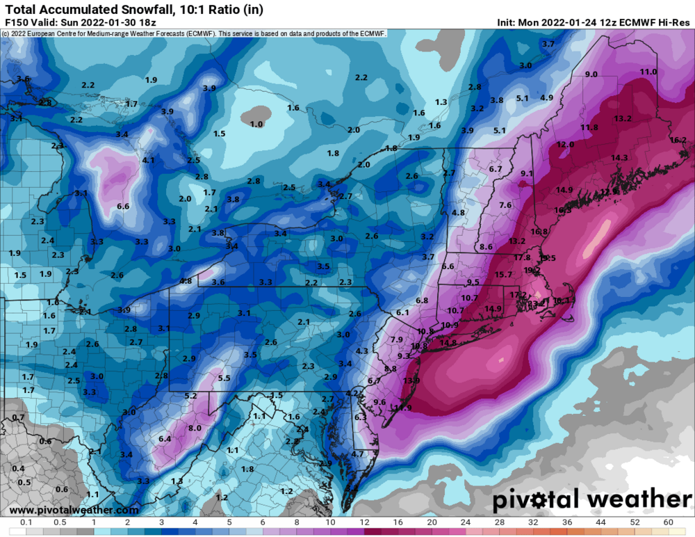
Powerful Multi-regional/ multi-faceted east coastal storm now above medium confidence: Jan 29 -30th, MA to NE, with snow and mix combining high wind, and tides. Unusual early confidence ...
in New England
Posted
Not overreacting yet. Let’s see if we get the inevitable jog back west at 0z. Won’t take more than 50-75 miles back west