

HinghamBoss
-
Posts
380 -
Joined
Content Type
Profiles
Blogs
Forums
American Weather
Media Demo
Store
Gallery
Posts posted by HinghamBoss
-
-
5 minutes ago, CoastalWx said:
Legit snowstorm now. Maybe half inch colder surfaces. Yay lol.
It is comical how similar all of these are. Rains for hours, we get our ceremonial 1-2" on the way out.
-
 1
1
-
-
Flipped over to almost all snow now. Let's see what we can do in next 3-4 hours. 2" of paste would be a win.
-
Looking at temps, anyone to the south and west of route 3 is snowing. Seems like the R/S line is slowly working east from Rt 24 to Rt 3.
-
Snowing in seemingly every other direction except here. Can't have nice things.
-
Heavy rain here. Love that it is snowing on the Cape though.
-
1
-
 2
2
-
-
Just now, ORH_wxman said:
I think the place is want recon for this storm is up in the Great Lakes because that will tell us if the northern stream is trying to get enough subtle interaction to crush us….that’s where the differences have been.
@Typhoon Tip mentioned this earlier as well and I agree it’s the northern stream being the key player. Not saying the southern downstream ridging isn’t important, but the northern stream evolution is what gives the room for the downstream ridging to amplify.
At this stage, how much of a shift can we expect? Realize the ridiculousness of the question given how today played out.
-
One burp north and this can be a face saving ~6 inch storm for BOS to HFD south and east.
-
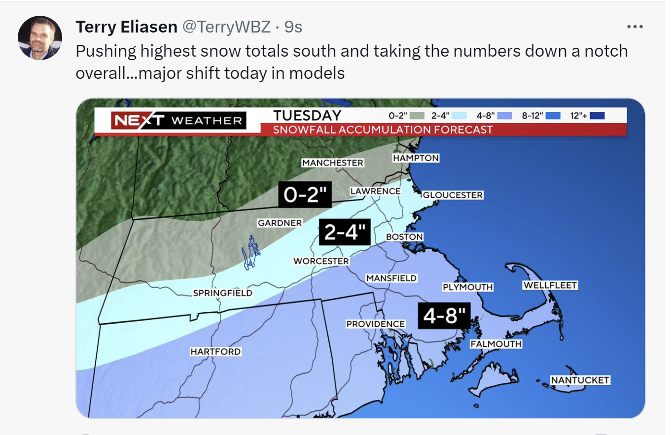
From BOX:
.NEAR TERM /THROUGH TUESDAY/... Key Points... * Quick hitting Winter Storm Tuesday, though the trend has been less snow and quite a bit further south. * Generally thinking the bullseye will be over southeast MA/southern RI where 6-10 inches is possible. * Dangerous travel possible with widespread 1-2" per hour snowfall rates possible Tue AM through the afternoon. May even have brief instances of 3" per hour rates. * Wet snow & strong winds along the coast may result in power outages. -
6 minutes ago, CoastalWx said:
Reggie still has an inch to PYM and half inch at BOS. Gonna me a good band in between.
Your 4-7 prediction here may all work out...albeit not how we envisioned it.
-
Just now, RUNNAWAYICEBERG said:
Have you seen the last 25 pages?
Indeed. Hence why I was scratching my head that warnings in place in the spots they were, plus adding further S and E. Feels marginal if criteria will even be met there.
-
Am I seeing things right - did BOX expand Winter Storm Warnings to the coast?
-
 1
1
-
-
-
4 minutes ago, CoastalWx said:
Blows for BOS. You aren't getting 10:1 snows. It's probably like 2-3" at BOS.
Total debacle. Ironically, down these parts the temperatures look better.
-
2 minutes ago, Prismshine Productions said:
No words.


Sent from my SM-S146VL using Tapatalk
The 3K map looks nice, but I don't see a world where SE MA is putting down 10:1 ratios.
-
1
-
-
What's fascinating here: the models have largely been consistent for days on end.
-
Just now, STILL N OF PIKE said:
I like how it bumps up in N orh county and even N or route 2 in NE mass
Have looked at those throughout the winter and every storm has been way overdone.
-
Feels like the goalposts are narrowing and we are getting to some level of consensus. There's going to be a 4-6 hour window tomorrow that is going to be fun - for many of us, the most fun we have seen in a couple years.
-
2
-
-
2 minutes ago, CoastalWx said:
I’ll lean 5-8 here. Could see higher west and above 200’ or so. I’m having trouble going higher locally. I suppose nam thermals would argue higher.
Could see a scenario where you are closer to 8 and I am closer to 5-6.
-
I dunno what the exact totals will look like around here, but if the Euro verified it would be a fun few hours.
-
1 minute ago, CoastalWx said:
The fact that a storm that tracks the way this does has boundary layer issues to start is ridiculous.
Story of the last two years. Remember the same sentiment last storm.
-
1
-
-
13 minutes ago, CoastalWx said:
Maybe 4-7 as a first guess.
I am not asking for much - 6 would be fine. 4 would be a disappointment.
-
1
-
2
-
-
What kind of ratios should we be looking at south and east of BOS? This has the feel of 6” of paste down these parts while someone puts down 12” in Milton/Foxboro.
-
A storm of yore - regionwide 6" storm - would feel like a home run right now.
-
The theme of 2023-24 for SNE: 12 hours too late.

Significant Miller B Nor'easter watch, Apr 3rd-4th
in New England
Posted
Was not banking on this one to work out given the situationals/time of year, but the last couple of days evolution is completely on script with last two years around these parts.