

jaf
-
Posts
103 -
Joined
-
Last visited
Content Type
Profiles
Blogs
Forums
American Weather
Media Demo
Store
Gallery
Posts posted by jaf
-
-
3 minutes ago, wxsniss said:
24hr snowfall on 6z GFS, 10:1
key thing to highlight... this is all under 84hrs I think for the first time this season...!

Hmm, was it out all night drinking?
-
Just now, CoastalWx said:

Lol, looks about right
-
 1
1
-
-
Does anyone have a snowfall map for the 6z GFS and Euro?
-
About 3" in Attleboro
Flurrying now
-
Hopefully I won't have to take out the snowblower if it's going to be a non-event.
-
9 minutes ago, MJO812 said:
Here comes the euro for next weekend . Nothing like the gfs .
Whiff?
-
From 3 feet to 3 inches over the course of a few days
-
1
-
-
16 minutes ago, MJO812 said:
Ukie on board with a cold coastal storm.
Can you see beyond hour 144?
-
32 minutes ago, ORH_wxman said:
Ukie is definitely not going to get it done for us easterners. Good run for CT though.
Toss GFS?
-
0z CMC is way out to sea
-
1 hour ago, 40/70 Benchmark said:
Show me 3/4.
I'm already focusing more on that following storm that will probably disappoint us too. I'm feeling 3 feet in the mountains and 3" here turning to rain.
-
4 minutes ago, HoarfrostHubb said:
Definitely too early. Maybe start one next Tuesday or Weds. lol
If we wait too long there won't be a threat anymore.
")
-
 10
10
-
-
Just now, Henry's Weather said:
Happy to have ya on the board, but you might want to redirect this stuff to March discussion
Should we have a thread for this one, or too early?
-
3
-
-
The late week storm drops 2 to 3" qpf ... but I'm assuming that is rain?
-
GFS had over 1" qpf over a large area of the region. Pretty good
-
The huge 2-3 foot solutions only came from the Euro, and only for a couple of runs, right?
-
I feel like March 4 has more upside - a juicier system. Also the risk for rain or a total whiff.
-
1 minute ago, TauntonBlizzard2013 said:
Not sure about rain. Could be a pretty meh event though if trends continue. You’d be relying on the initial thump entirely, which has been trending north
I'm totally expecting meh at this point. Even meh is better than we've had so far. But I don't really care if we don't get 2-4". If it's not a big deal, then I don't really feel like shoveling at all.
-
2 minutes ago, TauntonBlizzard2013 said:
Two fold problem. No trailing SW interaction, and late and north transfer. Result is an event with a ceiling of low end warning
Do you think us in the Taunton/Attleboro area end up changing to rain like we have 100 times before this year?
-
The storm next weekend continues to be there, and continues to insist it will only marginally affect us before going out to sea.
-
There's another system a couple days later, but looks like rain. Then there's that big storm that following weekend on all models, but it misses south. Some things to track at least.
-
1
-
-
Correct me if I'm wrong, but it looks like the Euro phases, but it's too far offshore
-
This looks like a good dumping on the 12z GFS
-
13 minutes ago, jbenedet said:
That's a sig block incoming, peaking right around this storm's closest approach. Strongest -NAO we have seen all season.
Great for coastal SNE and Northern Mid Atlantic. Too much of a good thing for the northern folks, is my take.
 14 minutes ago, jbenedet said:
That's a sig block incoming, peaking right around this storm's closest approach. Strongest -NAO we have seen all season.
Great for coastal SNE and Northern Mid Atlantic. Too much of a good thing for the northern folks, is my take.
Would that block allow the other shortwave to catch up and phase, or is that still unlikely?
Currently monitoring guidance for March late 3rd through the 4th for the next ( beyond the 28th) significant event
in New England
Posted
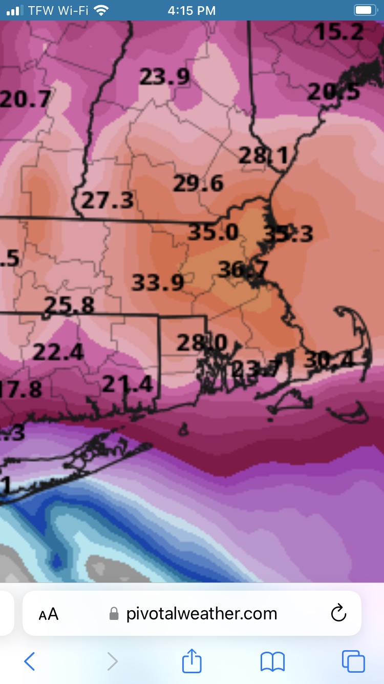
Is this the proper snowfall map from the 12z GFS, or the one that shows 3" in Providence?