

bigtenfan
-
Posts
274 -
Joined
-
Last visited
Content Type
Profiles
Blogs
Forums
American Weather
Media Demo
Store
Gallery
Posts posted by bigtenfan
-
-
Classic example of the old saying that even in a lesser year all you need is one storm to make it memorable.
-
That map is for tropical storm winds and depending on the exact detail shows the landfall area at a 50 to 80 percent chance of TS winds
I am sure that the 50 and 64 kt wind maps showed even a lesser chance
I am sure that map was based on the GFS which failed miserably in this storm at the cost of many many lives
-
The thing is that Florida actually has some of the best and strongest building codes in the country at least since 2005 and to a lesser extent since 1992. My own house here in Boca is built to withstand 155MPH winds and a recent garage door replacement is rated at 235mph winds. You will never see wood frame new construction in Florida. Everything is reinforced concrete and cinder block.
Personally I think that an issue that needs to be addressed is how the GFS and equally important the hurricane models that are based off of it was totally taken to school by not only the Euro but the UK model as well. This is not the first time that this has happened yet the NHC continues to weigh their forecast to what the GFS says.
-
 1
1
-
-
2 minutes ago, Normandy said:
As we move closer, there are two potential solutions developing:
- Solution 1 misses the connection on the first trough, causing the storm to instead slowly move NNW until eventual landfall on the N GOM cost (still likely Florida Panhandle, but some potential of a Alabama or MS landfall is on the table)
- Solution 2 does not miss the connection of the first trough, and instead the storm is yanked NE across SE FL. What's more concerning than even that, the trough does not take the storm out to sea and instead leaves it heading due North into a building ridge above. Even if it misses S FL to the east, it just means an East coast strike further up the coast.
In short: US is in SERIOUS trouble with this one.
Looking at the Euro which in itself is still very much an eastern outlier it would be more of a direct hit to the SW cost of Florida into central Florida . SE FL would still get some hefty TS force winds out of this but not a crippling blow.
-
3 minutes ago, cptcatz said:
Euro sticking to landfall around Ft. Meyers. This storm looks far bigger than Charley and impacts look to be throughout South Florida including Miami metro, similar to Irma.

That is still a fairly large westward move from 00Z which had it going right over both of our houses here in Boca.
-
I wonder how the 12Z Euro will look as they were by far the NE outlier at 00Z
-
1 minute ago, cptcatz said:
GFS showing Matthew 2.0 except this time riding up inside the coast instead of off the coast. A MH eye riding up through Dade, Broward, and Palm Beach counties would have to be one of the costliest and most destructive paths a storm could take.
Beat me to it by a minute
-
1
-
-
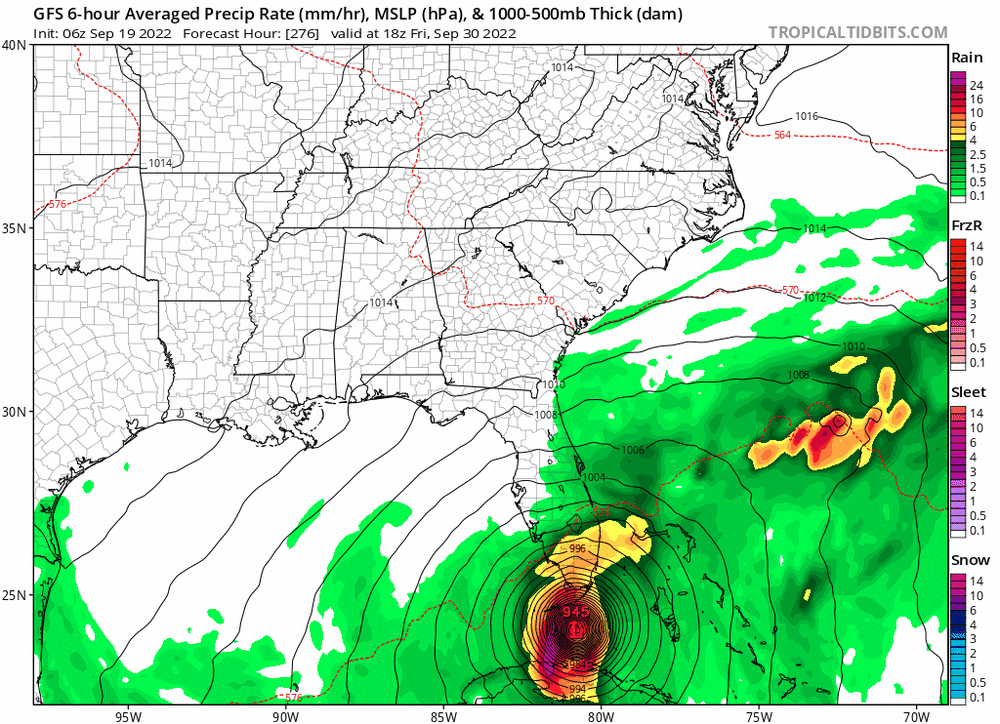
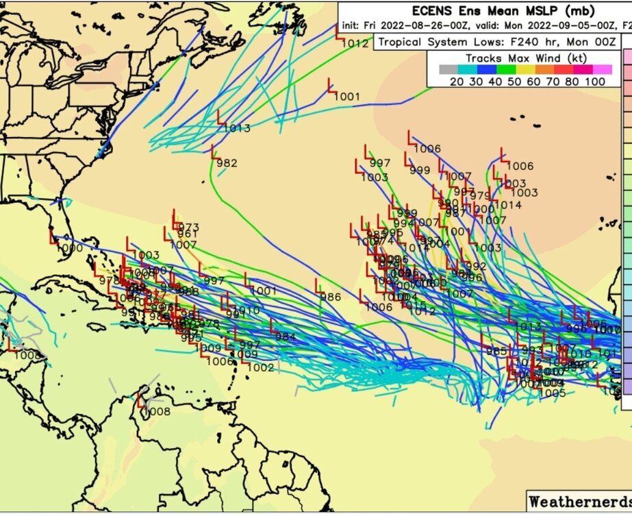
I am surprised that no one has mentioned what the fantasy range of the 6z GFS is showing. If that were to verify that would be at least a $250b storm. A major probable cat 4 straddling the coast from Miami to the Outer Banks
-
 1
1
-
-
Looks like the latest NHC cone has moved east by around 100 miles or so.
-
This may be a totally off the wall thought but over on the tropic site Storm2k there was a post bringing up 1976 which featured season long heat and drought in Europe and a similar hurricane season( SO FAR) to what we are having now. Those of us old enough remember the winter that followed in the east: historically cold but really not that much snow which was followed by 2 pretty cold and snowy winters.
Do any experts on this board have any thoughts on that analog?
-
The real question:
Does it form before midnight tonight to spoil the 0/0/0 for August.
-
2
-
-
48 minutes ago, cptcatz said:
00z Euro and CMC both with a hurri
 cane in the central MDR at day 10. Maybe this will be the one?
I am not an expert but looking at the lows to the north it definitely looks like there will be a weakness to allow it to escape OTS if it does form.
-
2 hours ago, cptcatz said:
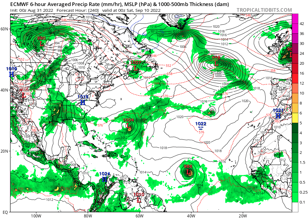
Very interesting last frame of the Euro model... intensifies from 986 to 973 while moving southwest.
Interesting solution. It does not appear to have any other model support even from it's own ensembles. Keep in mind that this was the same model that yesterday at this time had this doing a virtual 90 degree right turn to the NE.
-
1 hour ago, cptcatz said:
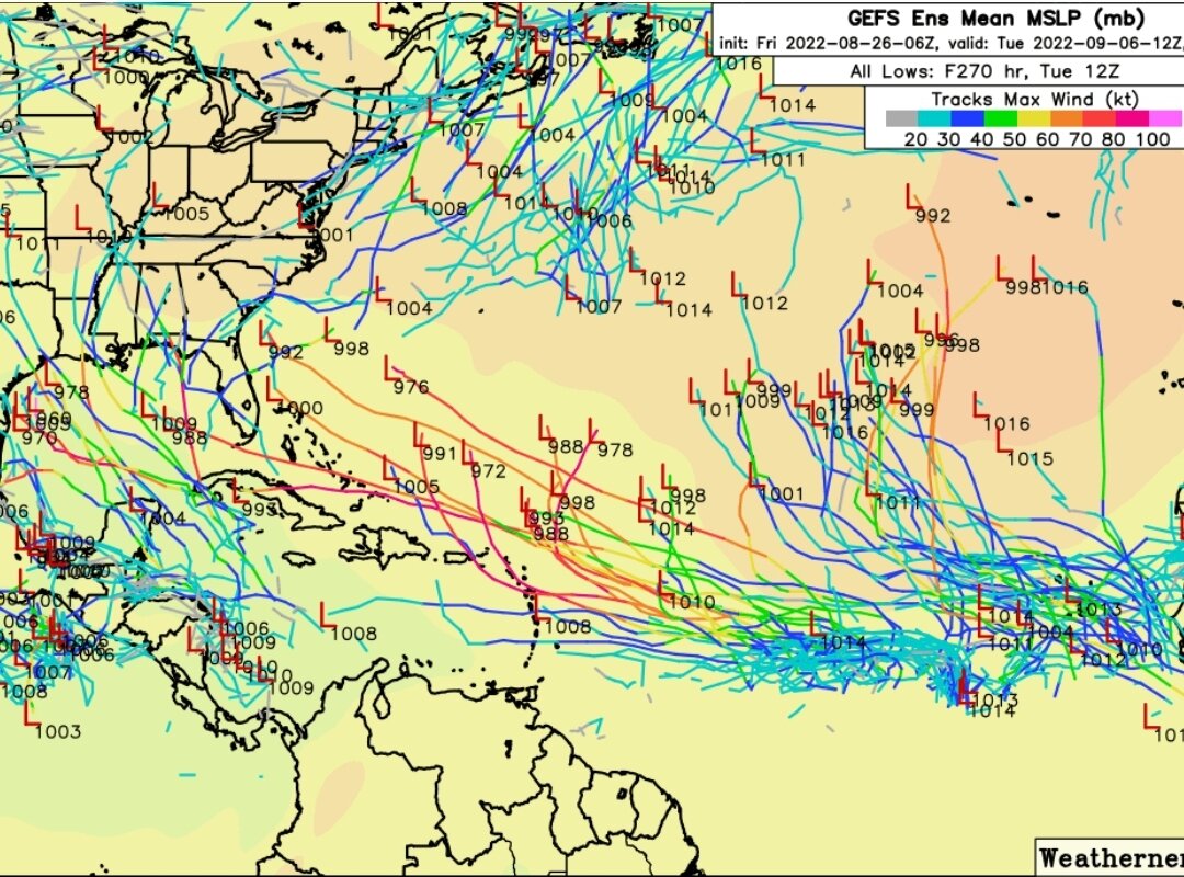
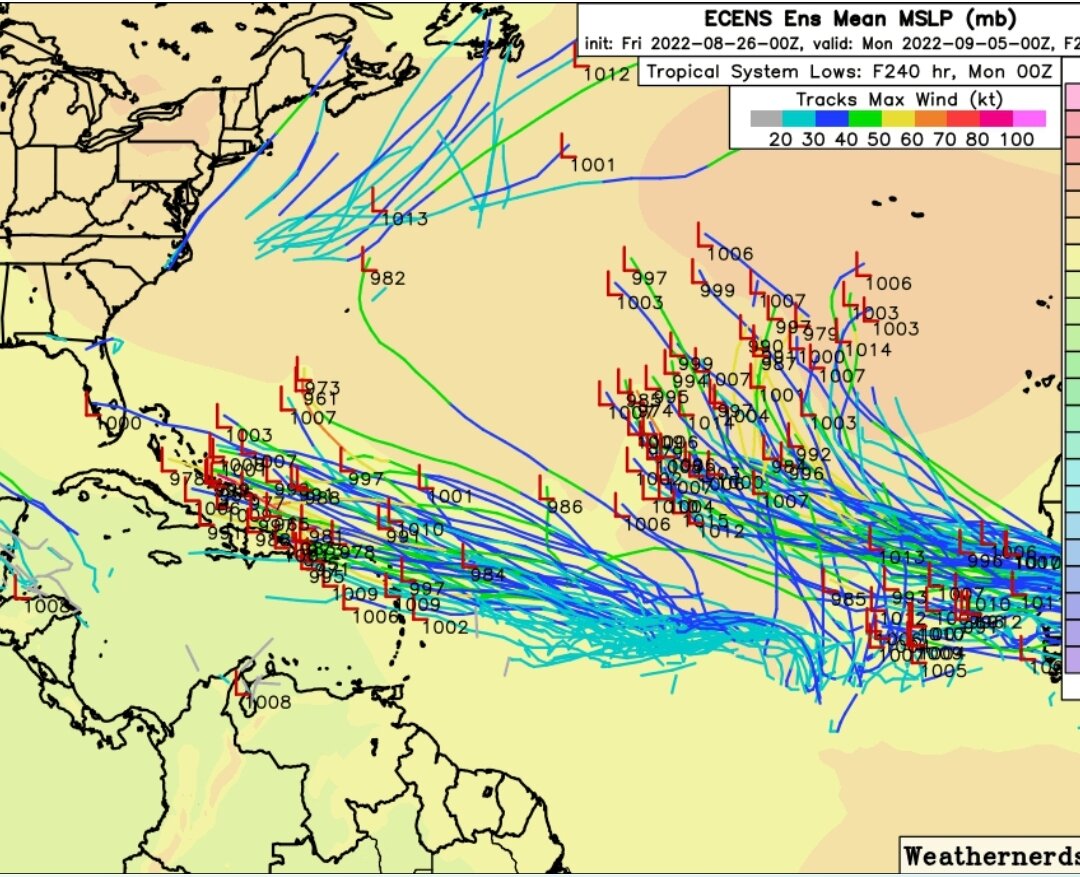
The EPS model on Tropical Tidbits go out further than 240hr and show South Florida is in play bigtime...

True but the way the models have bounced around this year I can't get too concerned about a few ensamble members 300+/- hours out.
-
1
-
-
39 minutes ago, cptcatz said:
I'm watching this closely from Boca Raton...
Me as well
It is hard to tell especially on the EPS which only goes out to 240hr but it looks like the projected trajectory of the vast majority of the members is suggesting recurve.
-
That 0z GFS run was very scary for S FL. Not only was it a direct hit but it hung around the S FL area for something like 24/30 hours with the rainfall measured in feet not inches. The fact that it was only 1 run and it totally disappeared on the next run and GEFS support for that solution was tepid at best I am skeptical of that actually happening.
As for the Euro, yes they have the second wave. To my very much untrained eye it does look like the 500MB surroundings will allow an escape out to sea. If you look at the last few frames there are certainly signs of a recurve.
All that said maybe it is time for us in S FL to review our stocks of hurricane supplies.
-
The fact that the NHC doesn't even have a 5 day lemon for the lead wave or the second one for that matter tells me that they at least for now are not buying what the GFS is selling. That can certainly change though if other models support what the GFS issaying.
-
For as threatening as the GFS and the GEFS looks to be , they appear to be alone. Unless i am missing something I see little if any support from from the Euro or the EPS, the CMC or the ICON.
-
This is starting to look like winter weather forecasting in the NE and Mid Atlantic the last few years. The pattern change was always 10-16 days away. and before you knew it, it was March .
That said i do believe that there will be activity during peak season in one way shape or form. Experts: correct me if I am wrong but La Nina years usually produce early east coast troughs . If that is the case then would that produce an early end to the season?
-
1
-
-
Funny thing about this forum. I can always tell what the latest turn of events is with regard to the Atlantic Hurricane Season by who has the last post
If the last post is from IDUB then the latest thinking is bearish.
If the last post is from Cptcatz thanthe latest thinking is bullish
-
1
-
 1
1
-
-
I am certainly not ready to cancel the season on July 27 but I must say that as I was flying into Fort Lauderdale this afternoon the Sahara dust over S FL was very apparent. As a S Florida resident I can only hope that it stays that way until November.
-
1 hour ago, JTA66 said:
Is he doing local TV anywhere again? I remember him being on Ch17 during the winter of 1995-96--perfect met for that winter!
Agree about him being the perfect TV met for that winter. He was the first to sniff out the blizzard of 1996 a full week in advance. Pretty impressive for the technology at that time.
Whatever he is doing now it is in Houston TX. I went back and forth with a member of the board that is in Houston on the tropical forum.
-
1 hour ago, Ed, snow and hurricane fan said:
Rainstorm was the one who used to post surface pressure forecast maps from the FSU experimental cyclone genesis model page to 'prove' no storms could affect the US?
Retired met Larry Cosgrove, who predicted the routine 100*F+ temps last month (warmest June on record) and continuing in Houston before it happened thinks position of ridging/SAL delays the start of the MDR season enough that CSU will bust high (but still above average season), but thinks September, while not that favorable for systems making the Gulf, has potential for East Coast landfalls.
I always had a lot of respect for Larry Cosgrove. Back in 1996 when he was a TV Met in Philly he was the very first to sniff out the Blizzard of 1996 a full week ahead of time. With the technology of 1996 as it was that was a great achievement
-
1
-
-
1 hour ago, MJO812 said:
Long range goofus

That would be a beast if it verifies( very unlikely). It would spend something like 60 hours near or on the FL west coast. The rainfall would be measured in feet in addition to whatever surge and wind damage there is.


Hurricane Nicole
in Tropical Headquarters
Posted
So how far further south does that translate to at landfall? Vero Beach area? That would still make it a N outlier.