
Caveman
-
Posts
219 -
Joined
-
Last visited
About Caveman

-
Central PA Winter 25/26 Discussion and Obs
Caveman replied to MAG5035's topic in Upstate New York/Pennsylvania
That is an excellent point concerning the skew of the 15 analog means by the 2 "outliers". It would be very interesting to be able to produce a map that does show the top 15 w/out the 2 "outliers"...but that is above my pay grade! -
Central PA Winter 25/26 Discussion and Obs
Caveman replied to MAG5035's topic in Upstate New York/Pennsylvania
This is from the CIPS website...kinda fun to peruse... https://www.eas.slu.edu/CIPS/ANALOG/analog.php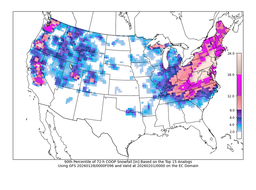
-
Central PA Winter 25/26 Discussion and Obs
Caveman replied to MAG5035's topic in Upstate New York/Pennsylvania
Same here in Valley Green, northern York County. -
Central PA Winter 25/26 Discussion and Obs
Caveman replied to MAG5035's topic in Upstate New York/Pennsylvania
As of 10 am, had 6.1" with a 0.54" liquid. Still about 0.25 mi visibility. -
Central PA Winter 25/26 Discussion and Obs
Caveman replied to MAG5035's topic in Upstate New York/Pennsylvania
Snow began ~3:30 am. 2.9" snow with 0.26 liquid. 11°F with 0.25 mi visibility at time of observation. 11.5 SLR to this point in the event. Valley Green, northern York County. -
Central PA Winter 25/26 Discussion and Obs
Caveman replied to MAG5035's topic in Upstate New York/Pennsylvania
Thoughts? I have many... -
Central PA Winter 25/26 Discussion and Obs
Caveman replied to MAG5035's topic in Upstate New York/Pennsylvania
That was the I-78 Lebanon County fiasco! -
Central PA Winter 25/26 Discussion and Obs
Caveman replied to MAG5035's topic in Upstate New York/Pennsylvania
-
Central PA Winter 25/26 Discussion and Obs
Caveman replied to MAG5035's topic in Upstate New York/Pennsylvania
From the National Weather Service... Blizzard Warning A Blizzard Warning means that the following conditions are occurring or expected within the next 12 to 18 hours. 1) Snow and/or blowing snow reducing visibility to 1/4 mile or less for 3 hours or longer AND 2) Sustained winds of 35 mph or greater or frequent gusts to 35 mph or greater. There is no temperature requirement that must be met to achieve blizzard conditions. -
Central PA Winter 25/26 Discussion and Obs
Caveman replied to MAG5035's topic in Upstate New York/Pennsylvania
Read the timestamps...kinda simple... -
Central PA Winter 25/26 Discussion and Obs
Caveman replied to MAG5035's topic in Upstate New York/Pennsylvania
That last sentence is truthful and hilarious...! -
Central PA Winter 25/26 Discussion and Obs
Caveman replied to MAG5035's topic in Upstate New York/Pennsylvania
Interesting...even from a slide rule old fart! -
Central PA Winter 25/26 Discussion and Obs
Caveman replied to MAG5035's topic in Upstate New York/Pennsylvania
That’s very cool! The communication of the numerical guidance in one succinct graphic! Awesome! -
Central PA Winter 25/26 Discussion and Obs
Caveman replied to MAG5035's topic in Upstate New York/Pennsylvania
Remember it well…sleet and heavy snow complete with lightning and thunder in the midday of the height of the 1993 March nor’easter! -
Central PA Winter 25/26 Discussion and Obs
Caveman replied to MAG5035's topic in Upstate New York/Pennsylvania
Nearly identical observations for the Saturday and Sunday light snow events from Valley Green, northern York County: Saturday: 1.5" of snow with a liquid eq. of 0.08" Sunday: 1.4" of snow with a liquid eq. of 0.07" Snow on snow is always kinda nice; NFL officials playing such a huge role in any and all games, well, not so much!


