

on_wx
-
Posts
3,054 -
Joined
-
Last visited
Content Type
Profiles
Blogs
Forums
American Weather
Media Demo
Store
Gallery
Posts posted by on_wx
-
-
For the record...over on page 50 I said EC's F5 rating for Elie, MB was suspicious. Just recently saw the video of the anchored house being torn off its foundation and thrown hundreds of feet as it explodes. Also saw photos of empty basements left where houses once were. There is surprisinly not a lot of damage photos and videos from that tornado. Sorry EC!
-
No idea if this was posted, but it's from "Cedar Ridge" in Joplin and states it's as the tornado was forming.
There is so much rotation!
-
Like this one taken by the apartment complexes on 20th.
He even says it. Right in the middle of the city and not a person or sign of life anywhere. I'd think people would be screaming and crawling out of debris assembling in the streets. It somewhat gives the illusion that "everyone is gone". Must have been absolutely hell.
-
New video uploaded Feb 15th. This is over by the high school.This is similar to the gas station video. It does appear a gust front hits the area first before the tornado arrives and there is such a long duration of destruction.
THERE IS A LOT OF CUSSING ON HERE.... but.... wow.
The one thing I always find so eerie about these immediate aftermath videos...is there is never another person in sight.
-
Still a 3 minute activation, however, if 10 minutes have passed between the last activation and the storm still has not arrived, they can blow them again for 3 minutes. They will also be able to activate them individually or in groups. They are going to start testing them individually on Feb 27th and silent testing will begin in the summer.
The solar panels are to charge the batteries if there is a loss of power.
Great news. Also, that sounds like they may be zoning them into areas that would go off if that area is in the warning polygon.
-
Ok second try...Joplin's siren policy was changed tonight.
Fire Chief Mitch Randles said this which is what I've been saying all along:
"People hear the sirens during the testing and the other warnings and they get desensitized to those sirens. So what we're trying to do by limiting the number of testings is to limit the number of times people hear the sirens to only when they need to take cover."
Tests will be conducted on the first and third Mondays of the month instead of every week like they were before.
2 sirens will be replaced and 16 upgraded with mobile activation technology, solar panels, and silent testing technology.
No word on activating the sirens more than once for a tornado warning?
I wonder what the solar panels are used for. Probably not the siren batteries, but for the new equipment to power a reserve battery so the sirens can still be activated from the EMA if the power is out.
-
This 'article' makes me want to stab a kitten. (that's a saying, I love kittens)
Did Global Warming Destroy My Hometown?
Last May, a massive tornado leveled Joplin, Missouri. Was it chance, or a warning of things to come?
Chance
-
MSNBC posted the article over tornado tourism.
-
Pictures of all the houses
-
If any Canadians are reading this...CityTV Toronto is airing the EM: Home Edition Joplin two-parter at 7pm and 8pm EST. WKBW Buffalo is airing them at 8pm and 9pm EST. Both tomorrow Jan 13.
Check your local listings
-
Had to be moving faster than the May '98 derecho to beat you at that

Hey, I was hit by that one!

-
CNN's nonsense was even worse on the day of the April 27th outbreak and the aftermath, I don't even want to go there because it will piss me off, tbqh.
It was also terrible on the Japan earthquake, too, but I can barely remember the April 27 coverage except they kept reporting live from the same spot as if that one small area was the only devastated area in all of North America. It's the only major US network I get on cable. It feels like years prior they had exceptional event coverage but this year had been lackluster for the network.
-
Just thinking back to that day... the tornado obviously caught all of us by surprise. In the thread everyone was focused on the Midwest and it wasn't until the 70dbz+ debris ball appeared over Joplin that people started posting. Then almost immediately after came Jeff P's dire spotter network report did anyone begin to realize what was happening. We couldn't get tv coverage, radio stations were out, scanners weren't available. Then sometime after, which wasn't more than probably twenty minutes, TWC's Mike Bettes arrived on the scene and we all saw the destruction first hand.
Well...
From what I remember... TWC went live, then national and international stations jumped on the story within the hour and it was a huge mess of confusion because no one knew what was happening.
One thing I personally remember and feeling anxious about was CNN's coverage. After posting in the thread, reading online articles, and watching TWC online... it took CNN what felt like hours to start to report the facts. The headline was "BREAKING NEWS: TORNADO SLAMS JOPLIN, MISSOURI" and they reiterated over and over that no news was coming out of the city, no one knew what was going on, and affiliates were en route... even though, what I remember, TWC was already reporting facts and information was quickly becoming available on, for example, social network sites.
CNN just kept talking about how it sounded bad, no info, then they got a hold of a chaser in Joplin who was at some highway service station that was skimmed and the chaser for probably an hour continued to report his story of "somewhat moderate damage, they saw trees down" etc.
Anyone remember this? I wonder what CNN's deal was. By the time they turned off live programming for the night, they still knew next to nothing, even though other outlets were factual and up to date.
Edit, I guess I've long wondered if maybe CNN doesn't have legal ground to report other networks information or reports and they had to personally send one of their legal affiliates to the scene before they could report.I have no idea how it works. But it was a frustrating night.
-
Not that I'm aware of. There probably will be local news coverage.
Cracks me up, lol

Well Ten for Joplin sounds like a great effort had to donate some to the cause and passed the link on.
As for just married
 is that beer cans??
 -
Next up.... 10 (houses) for Joplin from the Tulsa and Joplin Habitat for Humanity.
Thanks for the link

Oct 29 is the wall-raising with 350 volunteers expected! Any idea if this project will be featured on a tv show like EMHE?
-
In today's episode........
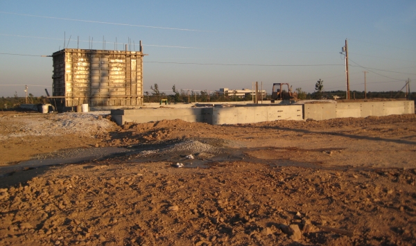
Storm shelters. I keep forgetting to take the camera with me so I missed a few, but here's a couple I've seen.
This looks like your standard inground shelter, but it's in kind of a weird place, maybe in the garage?:
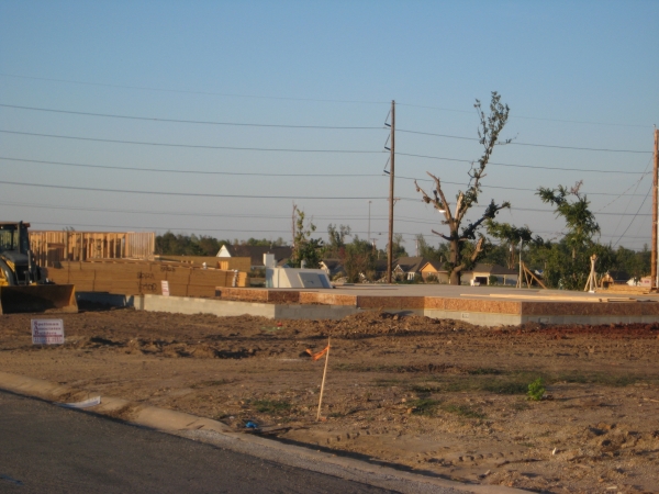
View from the back:
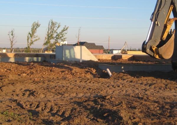
Believe this is a concrete indoor shelter poured inside the house, missing the top still:
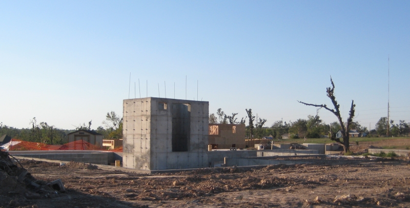
And believe this is one being poured:
-
I think the city is expecting all housing to be replaced, however I don't know if that's realistic considering how many lots are still for sale. The general thought is that once an area starts rebuilding, it will gradually 'fill in'. I've witnessed that over in my area with more homes being built around each other as time goes on. Some people are buying their neighbors lots in order to build a bigger house. There are some smaller lots that the city is not allowing rebuilding on. These are left over from the mining days and you couldn't really put a modern house on them. I'm unsure if the city is buying these or not though.
Storm shelters are left up to the people rebuilding to decide. I've seen a few inner concrete shelters poured and I've talked to people that are planning doing the same thing. It adds a few thousand dollars to the rebuilding cost but I would put one in. There are houses that have rebuilt without them though.
The city has applied for a FEMA grant to subsidize tornado shelters for those that want to get them, but the chances of getting that are fairly small. I have not heard about community shelters. I know there's a citizens planning committee that is looking at a variety of options on how to rebuild.
Seems a bit silly that people are rebuilding without using some of that insurance money to build a cellar. I think everyone here knows many won't build one. It happens time and again in tornado rebuilds, but man when an EF5 tears up half the city and kills hundreds, how can people just assume it wont happen again? How more apparent can it get... It reminds me off the TV show 'Greensburg' where that one family barely survived the tornado strike in their basement then rebuilt their lives in a modular home without a shelter. Just happy to have a home again. Tornado victim psychology 101 for another day.
And for community shelters, surely some plazas or churches are going to be designates. Frankly sad to hear you haven't heard of any going up. There is a mall I frequent in Port Huron, Michigan and all around the shops are signs that say 'TORNADO SHELTER --->", if you follow the signs you go to a set of stairs to an underground area with two entrances.
-
The area that the Huffman's live in is doing really well. It's not too far from me. I make note that it's building up fairly quickly over there when I take my monthly camera shots of the area. Some areas are slower moving of course, and there's still a lot of lots for sale by owner.
http://www.whnt.com/...0,2804113.story
JOPLIN, Mo (Reuters) - Four months ago, a tornado swept Rick and Jolene Huffman out of their house and dumped them unconscious into a clearing more than a block away.
A harrowing way to lose their home and nearly their lives but the Huffmans are rebuilding on the same spot, undaunted by memories of the tornado or devastation of their neighborhood.
*Construction contractor John Adams said houses in many neighborhoods destroyed by the tornado were 70 or more years old. People with patience and foresight will be rewarded for rebuilding, he said."Sooner or later they will be surrounded by new homes," Adams said. "It will probably be much nicer than it ever was."
A couple questions about rebuilding. Are they expecting something like a post-Katrina landscape with a couple houses amidst a sea of empty lots? If so, any plans to buy out lots and fill them with perhaps trees or just try to sell them off over time(which seems more logical)? Also, how about tornado shelters? With everyone rebuilding how many shelters are we talking? Or are there plans for large community shelters?
-
Interesting info on the sirens. I would have actually thought that once the tornado had touched down, they would leave the sirens on the entire time, but I guess they didn't.
Midland. They were on sale after the tornado. Thought SAME would be warning programmable, but apparently the Midland ones aren't.
It varies by area emergency management policy. Some cities will only sound their sirens if the NWS can confirm in their warning a tornado has touched down. Other cities will sound their sirens only once for 3-5 minutes when the warning is issued. Some sound them continuously. Others sound them once, then sound them again after a tornado is confirmed. Some cities use the siren tones in different stages. They will activate the "Alert" tone, or steady wail, at first warning, then if a tornado is spotted, they resound the sirens in the "Attack" tone, up and down wail.
Studies in Canada have suggested that the "attack" tone is most easily recognizable by the public that there is an immediate danger. I don't know of many areas that use the "alert" tone here. I studied emergency management so I know a thing or two about this kind of stuff on this end at least with a dabble in US happenings.
Some older versions of the Midland radio are programmable. The new version that comes with the flashing light accessory for the hearing impaired are not. You should look online for weather radios with SAME that can be programmed. You can order radios off company websites or other weather radio dedicated stores. You can also suggest to your friends and family which radio to get and can program it for them if they need it.
-
Also JoMo what weather radio are you using? I had a Midland radio with SAME, but you couldn't program the advisories. Bought a Radio Shack NOAA Public Alert weather radio with SAME in Erie, Pennsylvania. It's programmable.
And to add, something else irritating about the Canadian weather radio network. Warnings don't come out in polygons here, there is no "locations impacted" or "storm was near" stuff. All our warnings go out in "zones" that were created in 2002. Some follow the county system, other zones are completely made up by Environment Canada that just include cities every 20 km.
My regional municipality(urbanized county) is some 900 sq km. It's all one Environment Canada zone called "Kitchener - Cambridge - Region of Waterloo". If a storm is clipping the southern border, EC will issue a warning for "Kitchener - Cambridge - Region of Waterloo" thus putting almost 600,000 people under a warning, and my weather radio 30 km north of that storm goes off telling me there is a storm. Then, the weather radio only indicates what warning and for what zone. Warning text or discussion like "a storm capable of producing..." is not included in the Environment Canada network. So, I've had countless severe storm false alarms for a storm no where near me that I have to get of bed, turn on the computer and run the radar to see what's going on and if I should be concerned.
These Environment Canada warning zones are the sole reason why emergency preparedness fails in this country. You'll never be able to devise tornado plans for businesses and schools without risking the countless false alarms for the non-specific warning zones. Also majority of our severe thunderstorm and tornado warnings come in huge blankets. Sometimes warnings go out covering 10 counties(which would no doubt be the size of 30 Kansas counties) before storms have even formed. Even the tornado siren network fails in this country. So many times the tornado sirens have gone off for a storm that will never impact this area, but we're in a blanket warning.
-
I'm not sure about the call on the sirens. I'm not sure how long the battery lasts.
I agree on the weather radio. Even using SAME technology, you still get flash flood watches that come out over the radio at 4 AM with no way of only programming in that you want severe/tornado warnings. (at least on the one I have)
Joplin uses the Federal Signal 2001 siren
http://www.federalsi...D=4&lookup=2387
It's the most common siren in the US and it's spilling over into Canada. IIRC, the 2001 has a battery life of 30 minutes. If the power is still on, the siren can run for something like forty-five minutes before it needs a ten to fifteen minute break. If the power goes out mid-siren sounding, the siren won't turn off because the battery activates, but the pitch or sound it makes becomes a deeper tone because it's using less power so the motor chopping the air slows down. From what I gather about that article, Joplin believes if they run the sirens too long the batteries will die. But, the power would have to go out first, so as long as the power is still on, and the city can detect whether each siren still has main power, the siren can go off as often as the city likes.
I'm no siren expert, but I'm 95% positive that is how it works.
-
Big article in the paper today that takes a few more quotes from the assessment report. Apparently the Joplin and Alabama tornado assessment surveys are going together.
Memphis comes to mind where the city sounds their sirens for the entire duration of a tornado warning. Also, as the article states, Tuscaloosa sounds their sounds continuously, too. That city uses the same siren type as Joplin. Conflicting information? Joplin officials think the sirens will break if they run them continuously, but other cities are doing it just fine.
Also it talks about grants for weather radios. Even here in Canada, sometimes the weather radio network can be real annoying. Going off in the middle of night for something silly like a frost warning. I had to program mine to only sound for severe thunderstorm/tornado watches and warnings. If you mandate or donate those radios to the public then I imagine a lot of radios will end up stored away in the closest due to too many alert messages for some of the dozens of silly NWS advisory products that make their way through the weather radio network.
Weather radios should be restricted to just life threatening advisory products like severe storm and winter storm warnings.
-
This video shows a pretty clear tower cam shot of the tornado at about 1:00
-
Nunavut is missing off all those posted weather maps, just saying

Devastating tornado strikes Joplin, Missouri
in Weather Forecasting and Discussion
Posted
I still don't understand how even after an extremely devastating blow to the city, and number of near misses over the last decade, Joplin won't be using multiple siren activations aside from another sounding 10 minutes after the warning is issued if a tornado is confirmed or something along those lines. Topeka has the same sirens as Joplin and they will sound here throughout the entire warning. On Apr 27 they went off at least 6-10 times or more, and that was just for a doppler indicated tornado. They also continued to blow them even after the warning expired. My landlord says she heard them on and off over 40 minutes. One three minute window to hear them outside is not enough...especially in a large city where greater numbers of people are always coming and going.