BrianW
-
Posts
2,592 -
Joined
-
Last visited
About BrianW

-
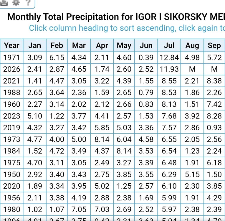
More rain coming in for BDR. Hopefully they will pull of the wettest July on record.
.thumb.png.61e7c250ce1b71291c143de39b88b6f8.png)
-
Just saw some 2.5-3 inch rates on my wunderground station at my sisters place on Pt Judith. https://www.wunderground.com/dashboard/pws/KRINARRA66
-
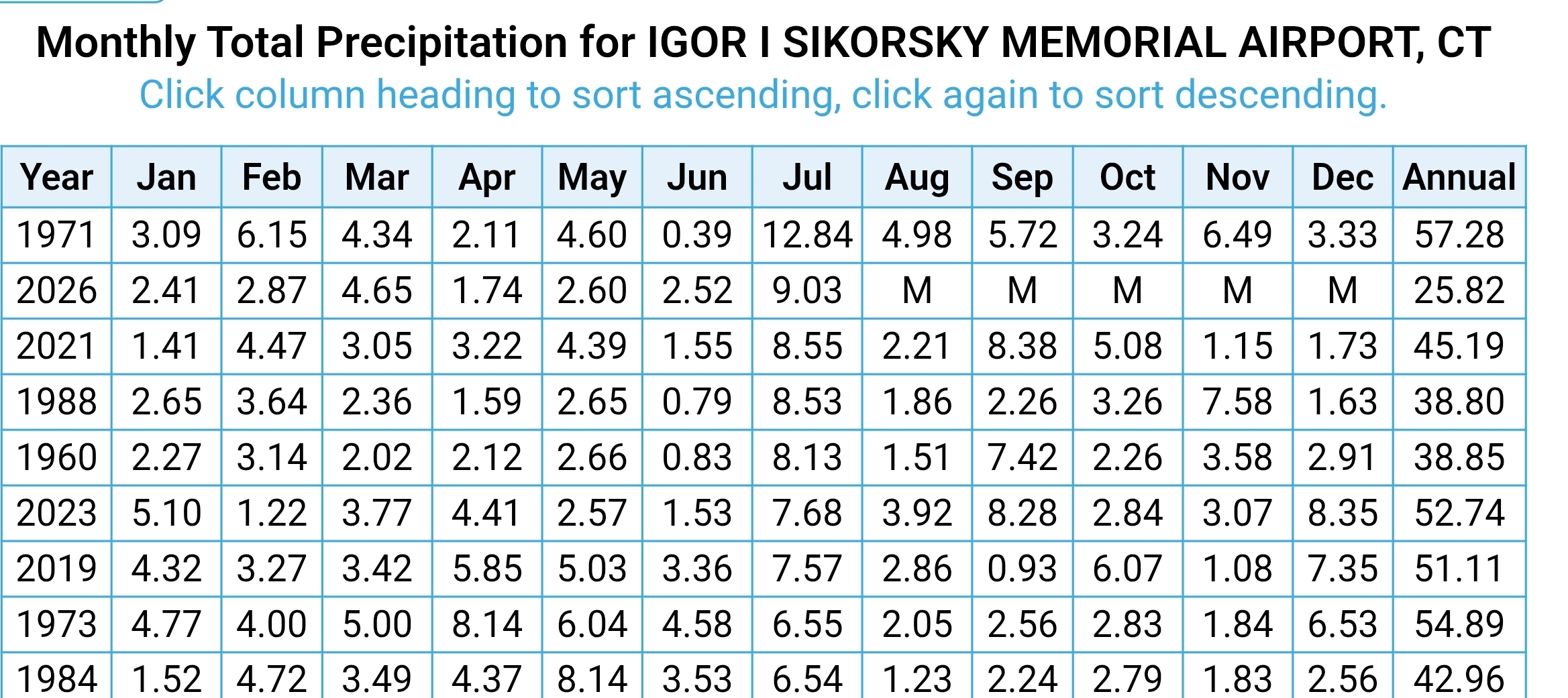
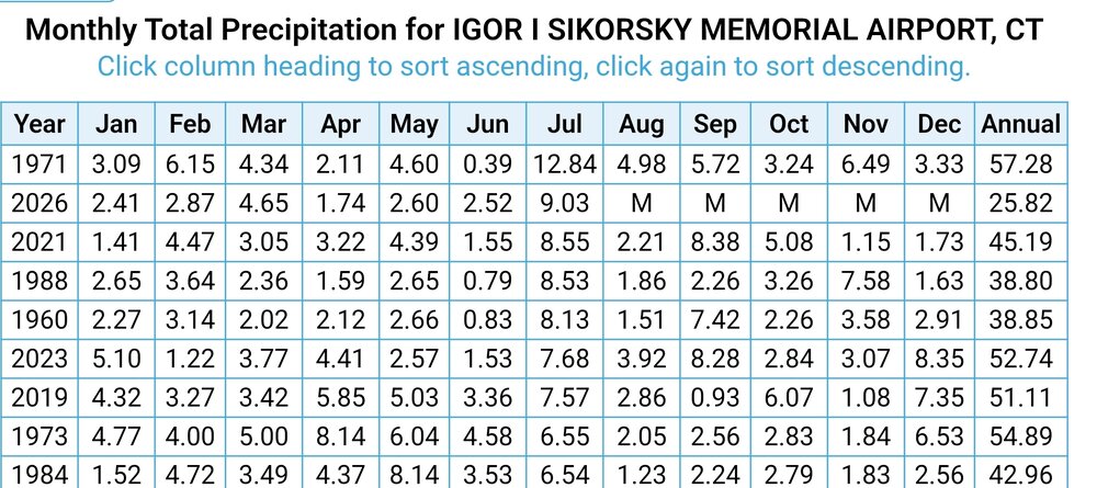
BDR is 2nd wettest July. Record is 12.84 July 71.
.thumb.png.ab466567c9c50a3d67a695cf55a6a3c7.png)
-
Working on a house on the water in Milford and its been pretty sunny all day. Tons of people on the beaches.
-
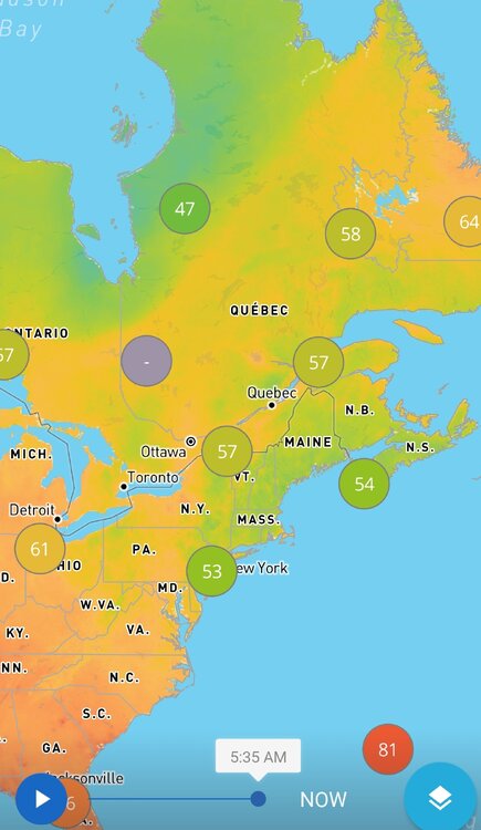
Yeah. You can see it on wunderground how New England stands out with some cool temps. Crazy how warm it is up near Hudson Bay.
-
Yeah. Nice to see the muggy meter back. Look at those dews launching right into Augdewst...
.thumb.png.e03ca9a0002e0b3e7345e1621ac33491.png)
-
Harbor Freight has a 2000 watt inverter for $500 thats decent. Those inverter units can adjust the engine speed to the load so they are crazy efficient. So if your just running a low load device it will run the engine at like 1200 rpm instead of 3600 at full load. All the larger generators run at a fixed 3600 rpm and suck down gas. A 6500 watt generator will go through a ton of gas often 5-10 gallons a day. Those ecoflow and anker solar battery packs are also pretty awesome. I got a 2kw one at Costco that can run pretty much any 120volt device. It will power a fridge for 24 hours and they can be charged from a generator, solar, car, and regular ac outlet. These 2 devices are like less than $1500 as well.
-
https://mesonet.agron.iastate.edu/ASOS/current.phtml?sortcol=ts&network=CT_ASOS&metar=no&sorder=asc&format=html https://xmacis.rcc-acis.org/
-
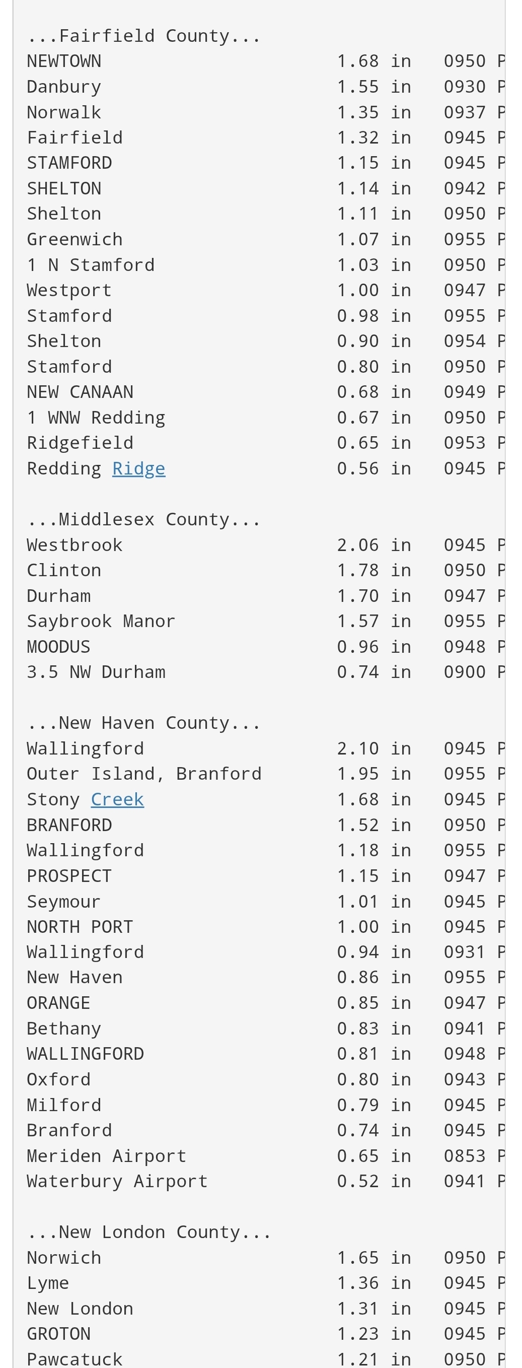
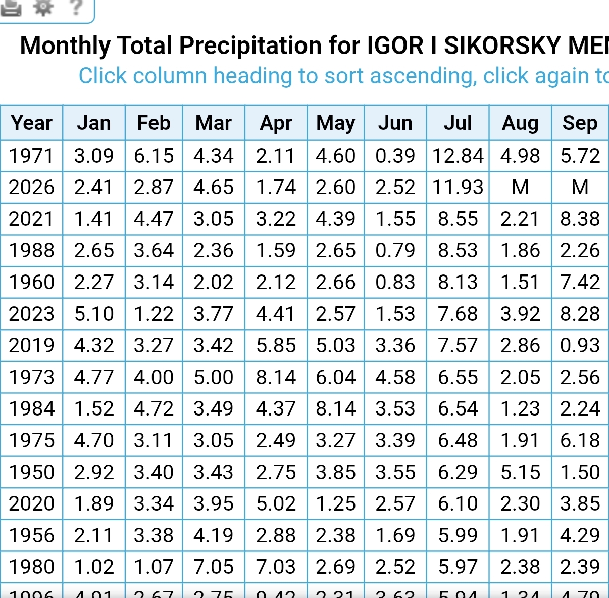
Just incredible rain here this month. Just standing water and mushrooms everywhere. 2nd wettest July at BDR with 9.03 inches.
.thumb.png.a5a8a75ae8ebb7e29a90e71c98f2da61.png)
-
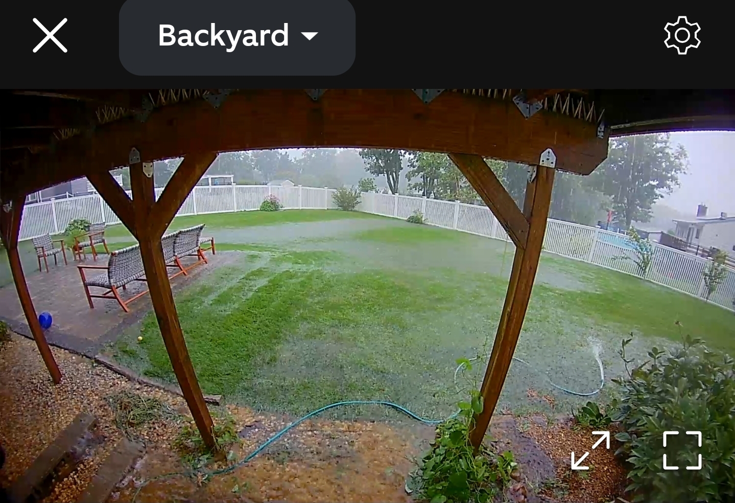
What a flooder here. Basement got overtaken. 3 sump pumps cant keep up.

-
Saturday, July 18, 2026 Thunderstorm/Severe Weather Potential
BrianW replied to weatherwiz's topic in New England
Another good drenching for the coast. 1.87 here and 5.46 mtd.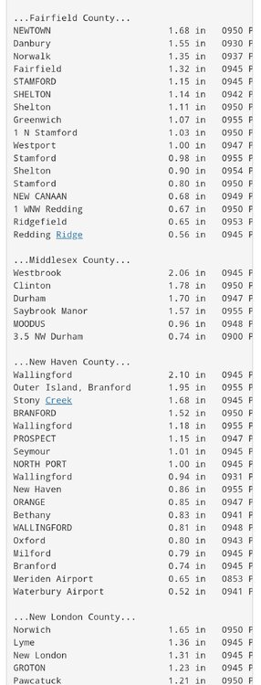
-
Eversource has a pretty crazy battery program available in CT and MA. They essentially pay you like 6x retail electricity rates when you discharge your battery to the grid during high demand. This is because New England still relies on tons of peak oil fired power plants. When those run electricity from them can be like 30x normal wholesale rates. These plants are crazy expensive because they idle 95% of the year and run off essentially diesel fuel. These oil plants are also used a lot in the winter when there are natural gas pipeline constraints in New England. ISO New England had an article a few years ago how New England burned something crazy like over $500 million in oil in 1 week during a prolonged cold snap. Here is some numbers from a powerwall in CT last year I saw online. The Eversource program is run through Tesla for payments. I think the math is these payments will pay for the battery in 5 years and they have a 10 year warranty. In 2025 there were 41 events during which my powerwall and solar setup sent energy back to the grid. • I received a check from Tesla for $1889.42 in February for these events. • On average, I sent 25.11kWh/event to the grid during each of these events. • I sent 1029kWh in total to the grid during these events. • For an average price of $1.84/kWh and average of $46.08/event. A kwh is currently around .30 in New England. Eversource bought the power from the battery at around 6x or $1.84 kwh during high demand. https://www.eversource.com/residential/save-money-energy/clean-energy-options/energy-storage-solutions
.png.3edda497a99106e8b8ad40a7dd6a4d2c.png)
.png.dbd7b694529b0d420363801948e746b1.png)
.png.5f1375f5b0847bd3be40923ee928af8c.png)


.png.f062c83c8548eb47831312d2cdf386f8.png)


.png.3c86979e8c8570f8ee2e5f3f01fe2c9f.png)