

Calderon
-
Posts
1,133 -
Joined
-
Last visited
Content Type
Profiles
Blogs
Forums
American Weather
Media Demo
Store
Gallery
Posts posted by Calderon
-
-
It's a whole string of embedded supercells headed for STL, and they're racing at highway speeds. There is a lot of outdoor events tonight, such as at Forest Park and the Missouri Botanical Garden in the city, for the holidays.
-
That concerns me, especially with the SPC comment that tornadic cells will increase in eastern MO
Yeah, the usually conservative tv mets here are becoming very concerned with the quick evolution of this group.
Starting to see a lot of mergers and cells becoming dominant.
. -
Very likely about to get a confirmed TOR near Marshfield, MO. That cell is on a perfect trajectory for STL metro.
. -
The activity over western MO will tell the tale for the northern half of the risk. We'll see if things stay more linear or if we can get more robust updrafts to become more individual.
-
Looks like at least half the house on pilings for the surge cam is gone.
-
 2
2
-
-
I'm surprised NHC didn't at least move the hurricane warning eastward to capture Hancock County, MS.
-
1
-
-
Well, that was a nice, intense group of storms here in southern St. Louis. Max gusts 70-75mph and the roar that preceded it for a good 2 minutes was fantastic. It's been a bit since I've had that much wind and near constant sound of trees snapping.
-
1
-
-
Just now, StormfanaticInd said:
"Damaging tornado likely."
Well no f**king s**t.

-
1
-
-
3 minutes ago, StormfanaticInd said:
Yikes!!!
Yeah, the CC drop on that supercell is very impressive.
-
1
-
-
I'm watching the chances of SVR basically cratering for STL metro with this bullshit slowly moving in from central & western MO. Still no SVR or TOR warning for St. Louis County & City the whole spring.
-
Well, that escalated quickly, and still no TOR watch yet.
-
CC drop really increased on the most recent scan. Without question still down.
. -
Looks like we’re getting circulation handoff as it’s approaching Rockford.
. -
Well, that escalated very suddenly.
. -
Likely tornado in Smyrna, TN at this time. 7 miles NW of my parents place.
. -
TOR warning for Savannah, TN.
.-
1
-
-
Cell near Ashland, MS has broad rotation.
. -
SVR warned cell near Ashland, MS has broad rotation.
.-
1
-
-
Cell approaching Perryville, TN is definitely getting together very quickly.
.-
1
-
-
HUN straight up issued tornado emergencies versus tornado warnings for a period on 4/27.
Also, literally every single thing was rotating that day. Tony Lyza posted something a few months back where multiple rain showers were rotating moderately before they even had achieved 40dBz returns.
.-
4
-
-
2 minutes ago, Cyclone-68 said:
Does anyone anticipate an upgrade to high risk at the next update?
I personally do not and think very few do as well. If, big if, they do, it'll be during Day 1 issuances but still unlikely for 06z given potential for warm sector contamination.
-
1
-
-
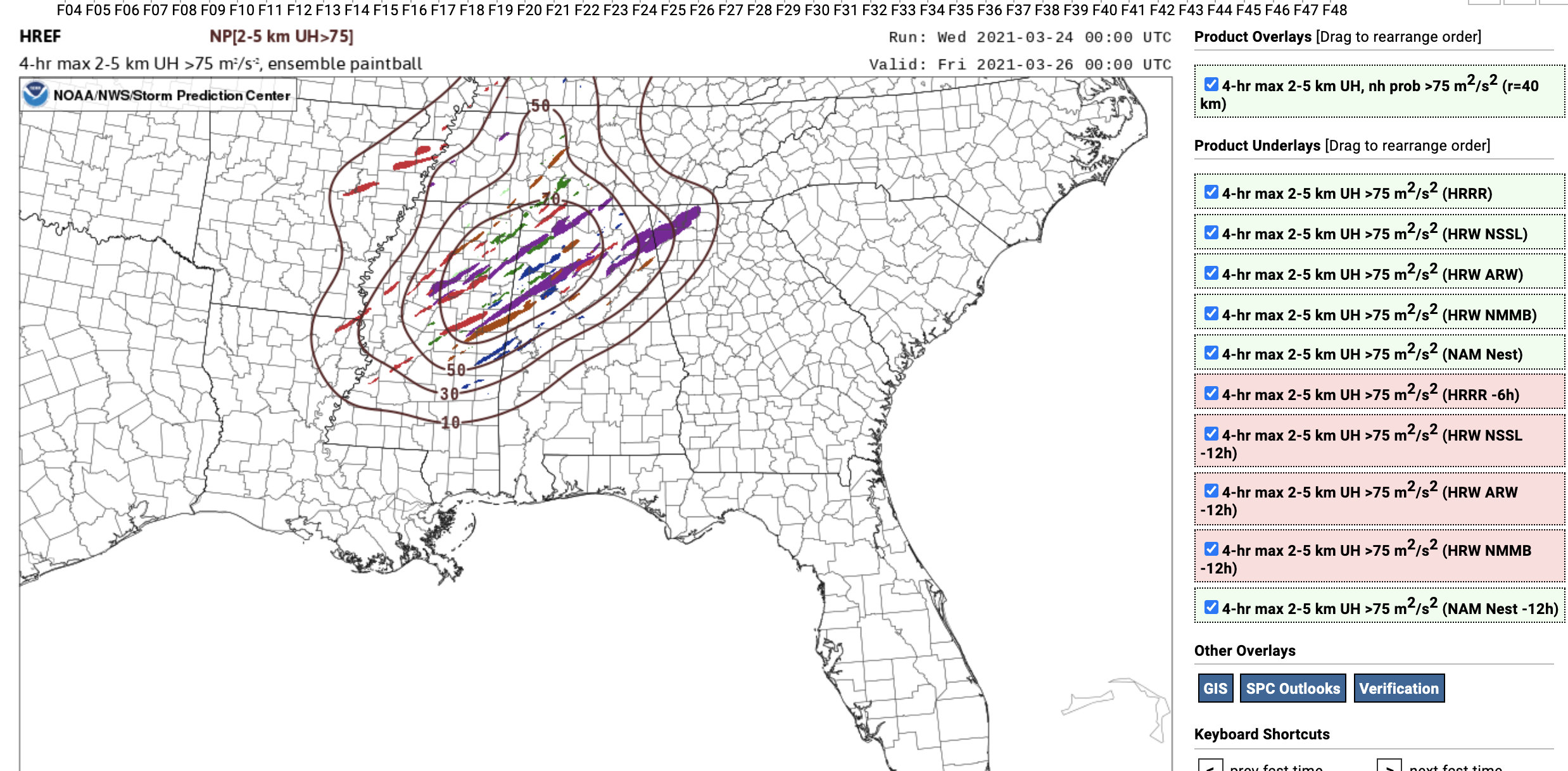
14 minutes ago, Cheeznado said:
3KM NAM obviously the odd CAM out. What impresses me are the forecast incredibly high 0-1KM SRH values of AOA 500. That is at the level of the 2011 superoutbreak. Not saying this will be as bad, but still impressive.

Oof, that is certainly a very high ceiling scenario, to say the least.
-
3 hours ago, nrgjeff said:
Cullman, AL sits on an elevated feature. One could say the Cullman feature hooks west from the end of Sand Mountain. At any rate elevated gets these locales up into the higher inflow winds.
While we can hypothesize on terrain here, I tell the public it does not matter. Don't assume protection. Don't be terrified by previous tornadoes. Just take all warnings seriously. Be aware but not (too) scared.
Don't waste energy on fear; just get the safe room ready. Usually I prep it with the Watch so the Warning is seamless. Overnights I prep the room before bed. Southern Discomfort!
If they ever question terrain, give them video of the Empire, AL EF4 from 4/27/2011. Such a beast.
-
1
-
-
Cullman, AL has entered the chat.
.
Dec. 10-11 Severe Weather
in Lakes/Ohio Valley
Posted
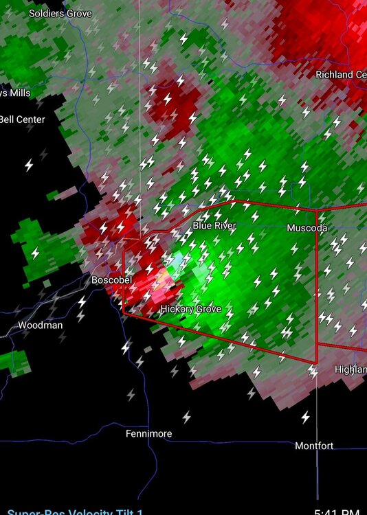
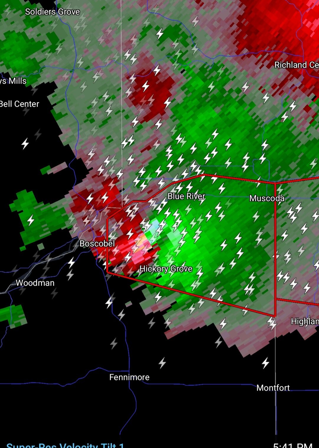
Confirmed tornado headed into STL metro, right towards the NWS office in Weldon Spring.
.