
MidlothianWX
-
Posts
1,786 -
Joined
-
Last visited
Content Type
Profiles
Blogs
Forums
American Weather
Media Demo
Store
Gallery
Posts posted by MidlothianWX
-
-
1 minute ago, skierinvermont said:
I mean who knows if it will bump as much as the OP's 40%, but the ridging north of the storm was stronger than 12z beginning from initialization. That ridging has been coming in stronger than modeled on the whole 18z and 00z suite.. pretty much all the models showed this to some extent.
Yeah, which validates BOU's suspicion that this system might ultimately take a slightly more southerly track than has been depicted by some of the globals.
-
It will be interesting to see what the ensembles say. I know we are very close to game-time now but BOU has said that they are creating their maps based off of ensemble blends.
-
Oh wow, the Euro QPF jump is impressive.
Boulder:
12z: 2.1"
0z: 2.9"
Denver:
12z: 2.1"
0z: 2.8" -
0z para has decided to bullseye Boulder with 4.3" qpf, hah.
-
48 minutes ago, Ji said:58 minutes ago, AlaskaETC said:I think most people here are on the east coast. Mountain West discussions are usually not that active. Snowstorms aren't a rare generational event here either...
Lol. Tney get monster storms every fall and spring. We get them once a decade:(
Having lived and tracked storms in the MA for ~10 years before moving here, I'll say that nothing beats a NESIS storm.
That being said, 20" events are a 1 in 5 year occurrence in Boulder, which might explain the lack of action here.
-
 2
2
-
-
FWIW, I've been following this guy since I moved out here and he is solid.
-
Interesting note from the NWS AFD this morning:
QuoteTo go more in-depth into the details, lee cyclogenesis will develop over northeastern New Mexico and southeastern Colorado today through tomorrow. Easterly, upslope flow to the north of this cyclone will create low clouds which will keep temperatures on the cool side across the plains of Colorado. One bias that models typically have in these types of setups is to position the center of the surface cyclone too far north. Cold air damming to the east of the Rockies should keep the center of the surface cyclone towards the southern edge of the model solutions perhaps ending up in northeastern New Mexico. This also means certain models, like the GFS, that have the eastern plains of our forecast area reaching the mid to upper 40s during the day on Saturday are way too warm. Temperatures will likely stay in the mid 30s.
-
1
-
-
Eyeballing 0z QPF from Pivotal maps...
GFS:
Boulder: 3.7"
Denver: 2.9"
Estes: 5.2"
CMC:
Boulder: 3.5"
Denver: 2.3"
Estes: 4.0"
UK:
Boulder: 3.7"
Denver: 3.4"
Estes: 3.4"
Euro (hi-res):
Boulder: 2.1"
Denver: 1.9"
Estes: 1.8" -
30 minutes ago, n1vek said:
I would try and stick around Boulder. Getting up and down the canyon roads might be incredibly really tough. Otherwise maybe Ward or Nederland would be a great place to get snowed in.
Yeah, this is kind of what I was getting at. If Wentz is fine with getting snowed in for a few days then I would go to Nederland or Estes Park for sure. Otherwise, Boulder is a safer bet.
-
34 minutes ago, Wentzadelphia said:
Hey guys looks like I’m flying out there tomorrow. Gonna figure out the complete logistics tonight. Last second decision as always haha. Should be fun. I’ve gotten some recommendations for spots so far (any state)...would appreciate any more. I need to find a place relatively close to an airport. I just chill at a hotel. Gonna need a gas station, rent a car, and WiFi and I’m all set ha
Boulder is roughly a ~45 minute drive from the airport and might be your best bet for this storm, assuming you want to stay relatively close as you said. Feel free to PM me if you need any help/advice.
-
Just now, n1vek said:
This is when it gets fun. Now we wait for the next run of the Euro. See who blinks first. Or we go into nowcast-time with the GFS dropping 80" in RMNP

QPF-wise, the other globals are closer to the GFS than they are the Euro. Regardless, the next few model runs will be very interesting.
-
10 minutes ago, smokeybandit said:
GFS just dropped me from 20" down to 10" from 12z.
For a model that was steadfast for a long time, it's all over the place now.The margins have shifted but the overall qpf picture for Denver/Boulder/FoCo has remained fairly consistent. For example, for the past 4+ runs the para GFS has put 5" +/- .2" over me. This 18z run continues that trend. Likely too juiced but it has been steadfast.
-
It appears the 12z Euro increased QPF in the Denver/Boulder metro to 2-2.5".
Can any local experts tell me how the Euro typically verifies in heavy upslope scenarios vs. the other globals?
-
12z GFS qpf:
Boulder: 5.2"
Denver: 5.0"Precip begins roughly 48 hours from now.
-
6z GFS holds serve with 5-6" of QPF from Denver north. This is a battle between the Euro and GFS/CMC/UK at this point.
Morning AFD from Boulder:
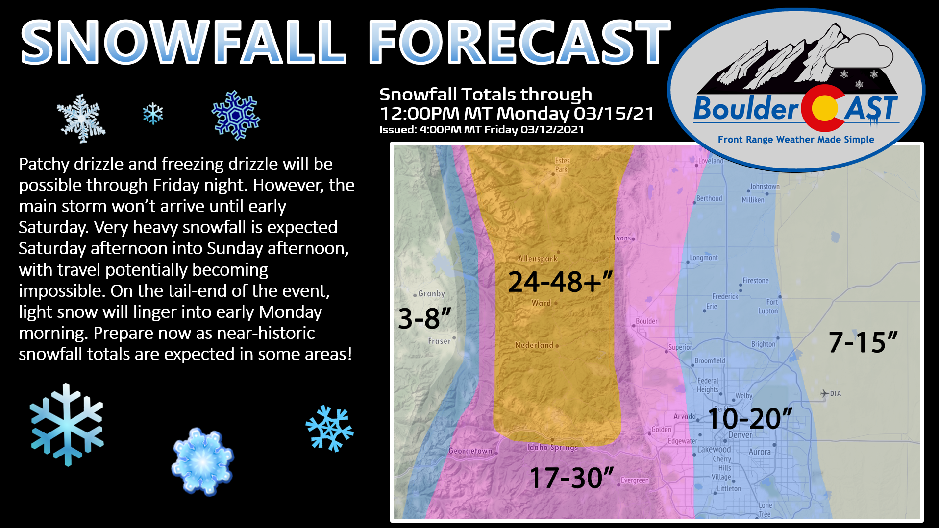
QuoteThe storm total snowfall forecasts were a mix of the global ensembles with lower weight placed on the GEFS. Amounts in the Denver metro are in the 15-25 inch range with Boulder and Fort Collins in the 20-30 inch range. The foothills will see the highest amounts with 2 to 4 feet likely. Given a more southerly track of this system, it would not surprise me to see a location or two in the northern foothills reach 5 feet. The area of highest uncertainty with regards to impacts will be the eastern plains. Amounts could be below Winter Storm Warning criteria there if the warmer solutions pan out. Or those areas could see close to a foot of snow with high impacts. There is high confidence in the impacts for the urban corridor and foothills with nearly impossible travel conditions Saturday night and Sunday. The Winter Storm Watch was kept due to the uncertainty with snowfall amounts with this storm especially farther east.
-
25 minutes ago, WeatherEmperor said:
What am I missing with temps? The latest tropical tidbits looks like a crazy rainstorm over the Denver area haha
You might be right. I could be looking at the wrong data on Pivotal. I'll leave the temp discussion to those who are more well versed in local climo.
-
QPF totals for 0z GFS:
Regular:
Boulder: 7.3"
Denver: 3.9"
FoCo:5.0"Para:
Boulder: 5.3"
Denver: 4.3"
FoCo: 3.5"This run seems a bit colder - I would presume this is all snow. Also, the storm keeps getting pushed back - light snow begins early Saturday, heavier stuff moves in late morning.
-
Forecast discussion from Boulder:
QuoteThe main event that has caught eye of weather enthusiasts will begin late Friday and into Saturday. It is also when the models begin to have larger disagreements. What models agree upon is that thunderstorms will develop along a dryline across western Texas to western Kansas as a surface cyclone depends over southeast Colorado and northeast New Mexico. Meanwhile, the cut off trough will move slowly eastward providing ample QG ascent for a long duration of moderate to heavy snowfall across much of our forecast area. What the models differ on is how quickly the cut off trough progresses eastward and how strong the upslope flow is. The GFS and Canadian are more progressive with the cut off trough and have stronger easterly winds at 700 and 500 mb meaning there would be better upslope flow. The ECMWF is slower with the progression of the trough and has weaker upslope flow. To give an example of the difference in upslope flow between the models, the 00Z GFS has an area of almost 60 knots of due easterly 700 mb flow across the northeastern plains of Colorado at 21Z Saturday while the 00Z ECMWF has between 25-30 knots of southeasterly flow during that same time. Considering the GFS has 60 knots of upslope flow screaming towards the mountains and foothills with strong warm air advection and QG aloft, it`s not that hard to believe the QPF output near Boulder is around 1.75 inches between 18Z and 00Z Saturday evening. The question is, are the 60 knot easterly winds at 700 mb in the GFS realistic? It seems unlikely. But could the upslope component of the wind be in the 35-45 knot range for a 12-24 hour period? That is much more likely. What peaks my interest is that the model that has the lowest ensemble mean for QPF in Denver is the ECMWF with a mean of 2 inches. That means at this time there are two main solutions, with one being a more intense but quicker moving solution (GFS and Canadian) and the other being the less intense but slower moving solution (ECMWF). With the models becoming more consistent with their solutions, confidence is growing quickly that there will be a high QPF output from this storm perhaps in the 1.5 to 3 inch range for Denver. There is high confidence that snow ratios will be quite low from a climatological standpoint across our forecast area. Soundings show low to mid level lapse rates will be near the moist adiabatic lapse rate while any isothermal layer that develops would likely be above -10 degrees Celsius. In addition, the warm ground temperatures and compaction will aid in lowering snow ratios. It is possible the average snow ratio may end up in the 8 or 9 to 1 ratio with this storm. Therefore, the messaging of 1 to 3 feet of snow for much of our forecast area is still on track. Winds will increase late on Saturday and through Sunday with gusts up to 45 mph possible across the eastern plains near Limon.
-
12z GFS QPF:
Denver: 2.3"
Boulder: 4.6"
FoCo: 5.7"Seems like a pretty harsh gradient. Also, Denver and Boulder flirt with the rain/snow line briefly on Saturday.
-
The 18z GFS says, why not crank it up a bit more?
Boulder: 6.3" qpf
Denver: 5.6" qpfKuchera says nearly 77" for Boulder - unreal. Definitely won't verify but it's fun to look at.

-
19 hours ago, smokeybandit said:
18z GFS is even more insane than 12z. Obviously that'll never happen but it's fun to watch. Then again those kind of totals are far into the danger zone for many people.
My biggest storm as an adult was in MD in 2010. We had two 20"+ storms within a week. It was nuts. The roof was creaking and I ran out of places to put the shoveled snow. It took a week to even get the neighborhood plowed so neighbors dug a path out to the main road.
I love reminiscing about the 2009-10 season. I was in Richmond at the time and followed every storm very closely on these boards. My love for winter weather was sparked by PDII though - I was living in Frederick, MD at the time and we received something like 25" which is still my all-time IMBY total (followed closely by Nov '19 here in Boulder).
If the 12z GFS is anywhere close to accurate though - and that is a massive "if" - I might be looking at finally breaking that record. Looks to be about 4.8" of qpf from Fri-Sun for Boulder proper.
QuoteBlizzard of '78 in metro Boston, baby. One for the ages. 30 inches of dense snow on top of 20 inches 2 weeks earlier, hurricane force winds, huge coastal flooding, school out for 2 weeks (yes, in MA), state of emergency for 1 week, the whole deal. I think Mike Dukakis wore the same sweater for like 10 straight days (look it up). That one got me started on weather. I still have a test tube of water from that blizzard in a box in the basement.
I chased Feb '13 in Boston. I want to say the final total was something like 26". Got knocked over by a wind gust, met Jim Cantore, and randomly bumped into a few AmWx members at a bar. I believe that was only the second time in history that they shut the roads down, after '78 of course.
-
The Boulder COOP station officially reports 22.3" for the storm. 20.7" fell between 5pm yesterday and today.
- #11 two-day snowfall of all time (needed an extra .3" for top 10).
- #3 two-day snowfall in the month of November.
- Daily snowfall record for November 27th.
- #3 daily snowfall of all time.
- #2 daily snowfall in the month of November.
The season snowfall total is now 55.1" vs. an average of 19.4" through the end of November.
-
1
-
Snow has completely finished here in Boulder. I measure 21" IMBY but the official COOP station right up the road appears to have at least 22" - we'll have to wait for their final report. Looks like the Euro was pretty much dead on with QPF, down to the hundredth of an inch.
This is a top 5 or 6 storm for Boulder since the modern COOP station went up in 1990. This is also likely to be a borderline top 10 event all-time. What a fun ride it was - probably the 2nd most I've ever seen IMBY.
@donsutherland1 I thought I would tag you, as I know you pop in here from time to time. Didn't want you to miss this!

-
2
-
-
14 minutes ago, ValpoVike said:
Measuring here is a futile endeavor because of drifts everywhere. There is a Cocorahs report from this morning of 29" very near to my house, which feels right so I'll go with that
")
Where does this rank for you, personally and/or for Estes Park?
Mountain West Discussion
in Central/Western States
Posted
Here is a snippet from the BOU morning AFD:
I was curious if they'd bump up totals a bit after the 0z runs but it looks like they are sticking with what they've got.