

Jebman
-
Posts
8,553 -
Joined
-
Last visited
Content Type
Profiles
Blogs
Forums
American Weather
Media Demo
Store
Gallery
Posts posted by Jebman
-
-
Love this vid shot in Houma during Ida!
-
 1
1
-
-
2 hours ago, Prospero said:
If an asteroid splashes into the Gulf of Mexico, I can be to the top of the Skyway bridge in 15 minutes and take live video until it gets washed away, and a helicopter swings by and miraculously scoops you alive off the Skyway. Then someone in Texas can watch it over and over on YouTube... Then we can both watch it over and over....
FIXED.
-
2 hours ago, Prospero said:
Water is amazing.
Just noticed in your signature:
"Only in northern VA can you get 12 inches of snow then 2 days later hit 57 degrees. DAMN ! Then Moderate RAIN that night. DAMN DAMN !!"
You should be in Denver or Colorado Springs where it can in the 70's early in the day, get 3 ft of snow in the late afternoon and evening, be near 10 degrees in the morning. Then be back in the 70's two days later.
")
I have heard of their wild temperature swings. I was upset about the mild weather because all I ever wanted, was the snow we got then more snow on top of it!
-
I dont think FL will ever have a tsunami.
Here is another good video, some surge in this one during Hurricane Delta, tho it might be freshwater flooding
-
4 hours ago, Maestrobjwa said:
Yep that's the crux of it...I think many of us here have a truly divided mind over this (like the proverbial good angel/bad angel on the shoulder, lol)
I dont mind a good strong hurricane, as long as it hits, say, Miami Florida. Chasers always chase them then I get to kick back and watch the storm to my heart's content on YouTube. Bring it ON!
-
We got another inch and a half of rain yesterday at 2pm. That brings us to 40.6 inches on the year and 8.3 inches of rain for August. August here is usually very dry and very hot, day after day of 103 degrees and clear blue skies with hardly any clouds. Not so this year, lots clouds and regular rains, kind of like what we see here in May. In May, we got 16-18 inches of rain.
-
6 hours ago, Prospero said:
Be sure to watch some tsunami videos on YouTube too.
I already love the March 2011 vids about Japan, and especially the Christmas 2004 videos about the incredible Thailand tsunami!
Kesennuma tsunami, that went right up the Okawa River! The power of that black water! Wow wow wow wow! What can I say?
-
1
-
-
This is a good one. Listen to that howl and roar!
-
1
-
 1
1
-
-
5 minutes ago, Tezeta said:
I kinda feel this tbh
You gotta admit the power, the ROAR, the incredible energy of a well developed Cane! Especially when you are safe about 769 feet above sea level LOL like me! I mean, I'm crazy about hurricanes but I dont place myself in danger lol!
Its so damned addictive! I'm addicted and I know I'm addicted!
Check THIS one out! Wow man, LIVE 28 foot storm surge! Wow wow!
-
I have got a confession.
I know I am 100% safe from hurricanes here in south central Texas.
I know for a fact that I will never actually be in a hurricane as long as I stay in my safe city, Buda, Texas.
The confession I have is that I am absolutely ADDICTED to hurricane chaser YouTube vids. I adore Hurricane Matthew in 2018. Mexico City, I love the violence and the ROAR of that beautiful wind! I love the chaser having to DRIVE thru the STORM SURGE! WHAT A FRACKIN' RUSH!!!!!!!!
I am so safe here. I can kick back and watch those vids in complete safety, and I absolutely yearn for more and more and more and more hurricane videos and secretly hope for a scary indomitable 200 mph sustained Gulf Coast Hurricane, because I know those highly addicted storm chasers will get me my prized hurricane vid, in which I'll get to see STORM SURGE! All from the safety and comfort of my favorite kick-back chair! I am so blessed! Nothing can possibly get to me in the landlocked fastness of Central Texas!
The best hurricane of all would be a monster 230 mph Cat 5 with gusts to 310mph behemoth slow mover, buzzsawing hell out of the Coast while storm chasers go completely CRAZY about it as they position and reposition themselves, get out of their well-equipped storm chase vehicles and get all excited and gesticulate at the fast moving threatening black clouds as the cameras are rollin' and I get to enjoy so many videos for all-time! It slowly moves inland then stalls and is so damned slow about decaying lol, and feet of fresh rain pile up while I enjoy the entire thing! Its amazing the way chasers will recall past storms, reciting many different years that 'Canes hit a location! Its very interesting!
Harvey was so fun! All that deep flooding! People frantically twittering for help while the water rose VISIBLY in kitchens! I absolutely adore global warming, love the oceans full of fervent heat! Imagine the sea level rise! Imagine entire coastal cities having to be relocated! Imagine hurricanes so bad that 50 foot storm surge becomes routine! Imagine the excitement of 4 foot rains becoming routine!
Man I loved that Hurricane Michael Mexico City video so much! I have happily watched it hundreds of times! I guess I am now the Hurricane Man, instead of the snow shoveling man.
I leave you with this beautiful video, my personal favorite.
-
3
-
 2
2
-
 1
1
-
 1
1
-
-
18 minutes ago, stockmanjr said:
Dont rely on NWS radars. Get myRadar! Its free and looks great! I use it all the time!
Sorry NWS, no disrespect intended to you, but I found a better radar!
-
7
-
 1
1
-
4
-
-
4 minutes ago, Will - Rutgers said:
i mean, it's pitch black, the storm is raging, and the water is high and rising. how the hell is anyone supposed to do anything, right?
We've gotta try!
-
1
-
1
-
-
If that levee was overtopped, it will get very bad.
-
1
-
-
Not sure if this has already been posted. Mods feel free to knock it down, but just HAD to post it -
.SHORT TERM...All eyes on Ida. Ida continues to strengthen through
the day and the 4pm advisory now has Ida at 105 mph with a minimum
central pressure of 976mb. Ida is forecast to still become an
extremely dangerous category 4 hurricane and could strengthen all
the way up to landfall which is now expected by midday/early
afternoon tomorrow. If you have not finished your preparations yet
FINISH THEM NOW! If you are under a mandatory evacuation...LEAVE
NOW! You do not want to play around with your life and it is not
worth it to stay if you have the means to leave.

Ida is moving to the northwest around a ridge centered over the
Atlantic coast around SC/NC. This has provided a very well defined
steering current leading Ida directly towards the north-central
Gulf. Ida has been gaining strength through the day and the
presentation on satellite is very ominous. A few very concerning
observations. Ida still hasn`t really rapidly intensified yet, and
the thinking is it still will and that now means that it could be
strengthening up to or just before making landfall. Even though that
hasn`t occurred it is already stronger than what the guidance was
initially expecting and it has been a slow increase. Ida is going to
continue to strengthen for at least the next 12-18 hours. There is
no dry air around, upper level outflow is quite impressive, and Ida
will move over the warmest and deepest part of the Gulf. This is all
very conducive for strengthening. What this can mean is that there
may not be time for an eye wall replacement cycle to get started
which would lead to some slight weakening but as mentioned already
it could be strengthening up to landfall.

The track has been sliding just a touch east of the forecast and
this is leading to some greater concerns with respect to surge in
some areas and rainfall potential in areas that just can not handle
heavy rain. First any more adjustments east will cause surge to
become a greater problem along the east facing shores of Louisiana.
The current track is going to bring UNSURVIVABLE surge up Barataria
and Terrebonne Bays. Much of coastal LA is just marsh so this surge
will penetrate well inland and unless you are within the Hurricane
Risk Reduction System you are putting your life in danger and do not
expect to receive any help if you are caught and cut off. This
includes both west and east of the mouth of the MS River in SELA.

Outside of those areas life threatening storm surge is expected to
occur in the tidal lakes and coastal MS. Lake Pontchartrain could
see 6 to 8 feet of surge and possibly even higher in the
northwestern sections of the lake around Tangipahoa Parish and
western St Tammany parish. Coastal MS especially west of Ocean
Springs could see up to 11ft. Locations that typically have tidal
issues in Hancock county should leave now as storm surge will be
extremely dangerous.

Winds will be dangerous to destructive through our entire CWA. The
most destructive winds will occur along the coast of Louisiana where
devastating structural damage could occur as winds are expected to
gust over 160 mph! This will severely damage to destroy most
structures that are not well built. Locations around New Orleans
could see winds that are far stronger than what was experienced last
year during Hurricane Zeta with much of the area likely seeing winds
gusts in excess of 100 mph. If there is any more of a jog east these
winds will be even higher. Winds funneling through some of the high
rises will be even stronger. Around Baton Rouge we could see wind
damage that far eclipses what was seen during Hurricane Gustav.
Winds gusts over 110 mph are possible that far inland. This will
lead to widespread tree damage, structural damage, and massive power
outages which could take weeks to restore. Across southwest MS winds
will remain very strong likely gusting over hurricane force around
Wilkinson County and gusting to near hurricane force as far east as
McComb. Northshore areas, especially along the lake could see wind
gusts over hurricane force with widespread tree damage and power
outages. Coastal MS likely to see winds gusts over 60 mph at times
which could still lead to damage and widespread power outages.

The other life threatening concern is heavy rain. This is two fold
though because of where it could fall combining that with the surge
in the lake and along the coast. We are anticipating a band of very
heavy rain that could be 15 to 20 inches and possibly higher. If
this falls over the city of New Orleans it will overwhelm the pumps
with extremely dangerous flash flooding possible. At the same time
winds could be dangerous and this would prevent people from trying
to find higher ground. Other areas of major concern is along and
north of I-12. This is the area where we have many rivers that are
quick to respond, Amite/Comite, Tickfaw, Tangipahoa, Bogue Chitto,
and across the MS border in coastal MS we have the the Hobolochittos
and Wolf. All of these rivers and a few more respond rather quickly
to heavy rain and the combine with the problem of surge into the
lake and along coastal MS. The surge will push up these rivers and
the rain will have no where to go and quickly lead to dangerous
flash flooding conditions. Combine the possibility of debris
clogging up other areas of drainage and widespread life threatening
flash flooding is possible. Please if you live in a flood prone area
highly consider leaving. If this rain falls directly over you the
drainage and rivers could be overwhelmed quickly and you could be
cut off with rising water.
-
4
-
-
I am really hoping and praying we dont end up with a 1921-like hurricane season in central Texas. Sept 7 thru 11 that year, Austin got drowned by 15 plus inches of rain from a hurricane.
We are already approaching 40 inches of rain so far this year, in a place that usually barely ekes out 30 inches in a year.
-
Got clobbered yet again here in south central Texas, 2 more inches, sitting at 39 inches for the year, 6.5 inches for August. We are WAYYYYYYYYYYYYYYYYYYYYYYYY above normal now lol.
Gardens are goin wild lol. Got lots and lots of fresh rainwater in huge buckets all ready to go.
Just when we thought it was dryin' up..........NOPE
-
1
-
-
4 hours ago, WxWatcher007 said:
No surprise the guidance is picking up on higher end solutions for Grace now that they’re initializing stronger, but good God at the strength of that ridge. That’s a legit Miami and Gulf threat.
Could be active in the Gulf this season. Lets just hope they all hit the E GOM. Central TX is already pushing 40 inches on the year. We really dont need another Allison lol. Or Harvey. Especially over Austin.
-
On 8/11/2021 at 6:22 AM, Eskimo Joe said:
He says a lot of things.
In this particular case, I think he will be correct. East Coast will get smashed by numerous major hurricanes. I think Florida and the Outer Banks are going to get utterly demolished, especially Miami. It is going to be very concerning the number of rapidly intensifying tropical entities that will smash into FL this season.
-
1
-
-
Larry Cosgrove thinks East Coast will get hit by hurricanes this summer/fall.
-
2 minutes ago, Rhino16 said:
I got a summer cold, which I don’t think has ever happened before. Getting better though.
Hope you feel much better soon! Hit the vitamin C, D and A. Drink as much water as you can and have chicken soup as hot as you can stand it with as much pepper as you can stand. Get lots of rest. It'll go away fast. Drink a lot of orange juice too.
-
Soil moisture is so high down here! Dewpoint is 81 degrees, but ambient temp is only 82!!!! Average high is 99. We got another third of an inch yesterday. That brings us to 4.5 inches just this month! Just wow wow wow wow! My tomato plant is growing vines all over and the watermelon vine is getting all over the place!
This much rain most of the spring and all summer is definitely very very abnormal for us. The lawn is emerald green. It should be brown and dusty.
Dewpoint is 81 degrees, I think this would be a very good time for a jebwalk!
-
1
-
-
2 hours ago, nw baltimore wx said:
Hiked up Mt. Washington today. We got very lucky and had one of their best weather days of the year.

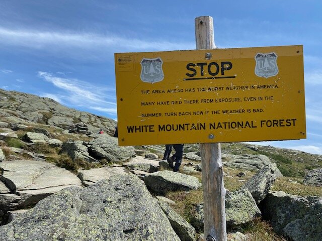
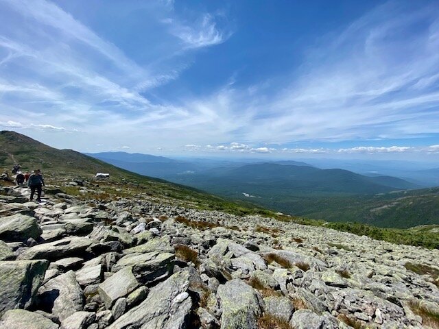
Absolutely resplendent! Couldnt ask for better weather, unless it was 5 degrees with thick clouds and 9 inch an hour snow rates!
-
2
-
-
17 hours ago, BlizzardNole said:
Yeah here too man! DCA has only recorded 3 days of 95 or higher so far. It's August 2 and my area woke up to a chilly 55 degrees and we are looking at highs in upper 70s to near 80 all week.
Wow 55 for a low! We'd find that very chilly! Today our dewpoint was 77 again and we got a total of 4.2 inches rain which brings us to a yearly total so far of 36.5 inches. This is unbelievable for us! Normal for this time of year might be about 19 inches.
-
What a very anomalous summer down here!
MORE heavy rain tonight, we just started off August with 2.8 inches of fresh rain! Normal high is 99. Naaah, all we eked out, was 94. Power went out for 2 hours as dangerous cloud to ground lightning smashed down all over at 1245am local time Aug 2.
More rain likely Monday and rest of week.
All this rain is abnormal. Aug is average high of 99 low of 74 with clear blue skies and hot, dry, dusty.
Not this summer. Lots rain. Struggling with the lawn and the cucumber vines are growing about 4 inches per day. I am having a hard time keeping them tied to the stake, which is already too damned short and has had to be lengthened. Same goes for the tomato stakes.
You guys want rain? Come on down to south central Texas. We are already up to 35 inches on the year. 30 inches is normal for an entire year.
-
3
-
IDA remnants OBS-nowcasts (storm total rain and/or unusual flooding, wind damage-power outage, gusts ~45+ MPH) Wed-Thu morning Sept 1-2, 2021
in New York City Metro
Posted
Oct 30 2015? Buda got 17 inches and Wimberley got 26 inches, that was the day I got my new laptop lol. BAD, BAD flooding in south central Texas. I didnt live down here yet, but I was down in Buda for 8 months in 2015 to get all my teeth removed lol.