
Blacksburg Coach
-
Posts
190 -
Joined
-
Last visited
Content Type
Profiles
Blogs
Forums
American Weather
Media Demo
Store
Gallery
Everything posted by Blacksburg Coach
-
Need Obs thread..
-
I saw that, and another round possibly after. I would be surprised as long as the cold is hanging around if we didn't see another after this weekend.
-
South Eastern thread is all about this weekend, figured I'd drop in and see what the mid Atlantic thought about next Wednesday.
-
A little, to quiet
-
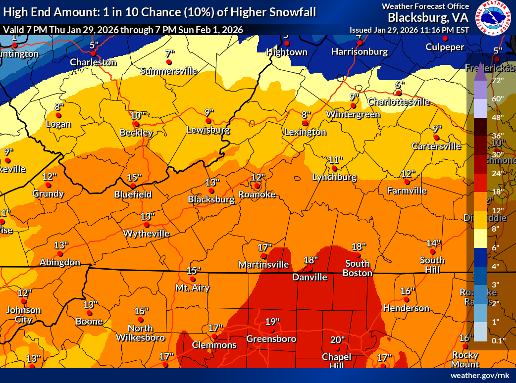
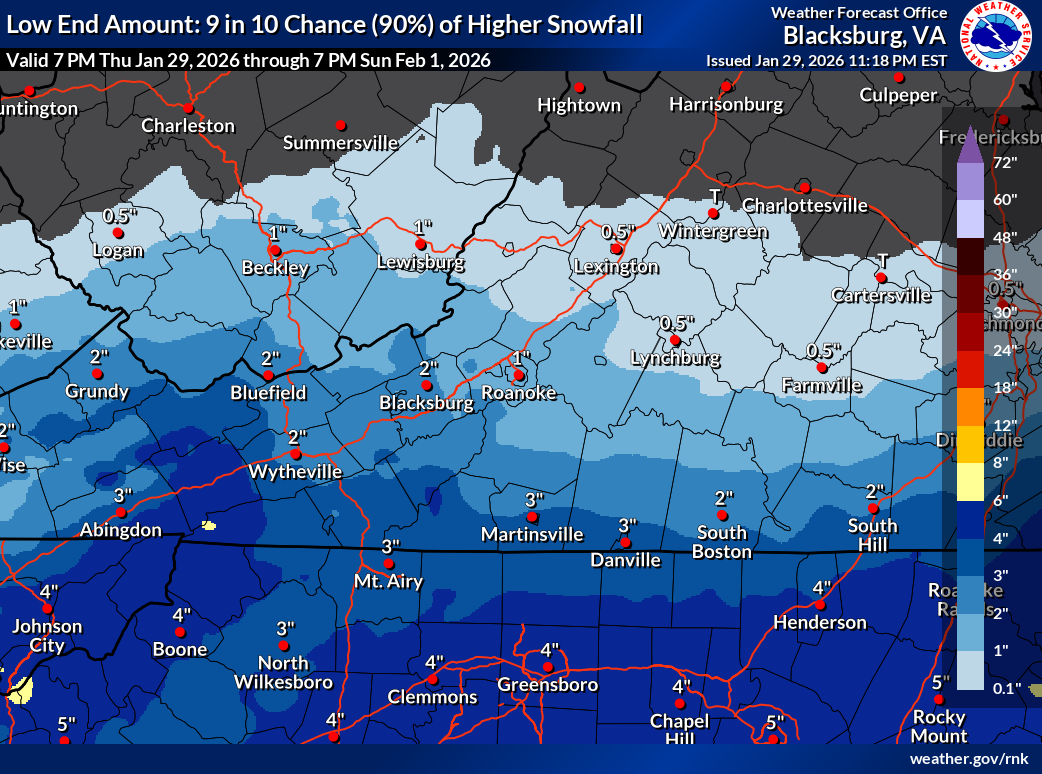
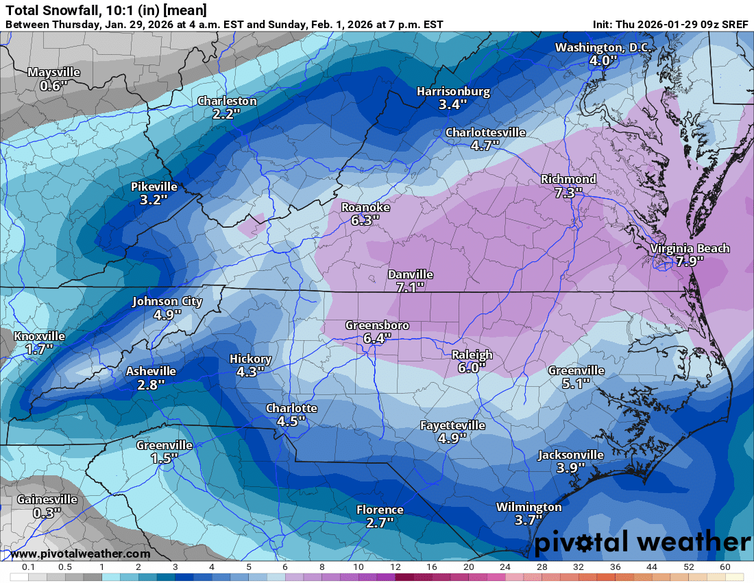
Winter Storm Warning URGENT - WINTER WEATHER MESSAGE National Weather Service Blacksburg VA 701 PM EST Thu Jan 29 2026 VAZ007-009>018-WVZ042-301215- /O.CON.KRNK.WS.W.0002.260130T1200Z-260201T1800Z/ Tazewell-Smyth-Bland-Giles-Wythe-Pulaski-Montgomery-Grayson- Carroll-Floyd-Craig-Mercer- Including the cities of Independence, Flat Top, Galax, Marion, Bluefield, Pulaski, Floyd, Wytheville, Radford, Pearisburg, Blacksburg, Whitetop, New Castle, Tazewell, Troutdale, Volney, and Bland 701 PM EST Thu Jan 29 2026 ...WINTER STORM WARNING REMAINS IN EFFECT FROM 7 AM FRIDAY TO 1 PM EST SUNDAY... * WHAT...Heavy snow expected. Total snow accumulations between 4 and 8 inches. Winds gusting as high as 50 mph. * WHERE...Portions of southwest Virginia and southeast West Virginia. * WHEN...From 7 AM Friday to 1 PM EST Sunday. * IMPACTS...Travel could be very difficult. The hazardous conditions could impact the Friday morning and evening commutes. Gusty winds could bring down tree branches. * ADDITIONAL DETAILS...Strong winds Saturday night into Sunday will result in blowing and drifting snow...reducing visibility at times.
-
Temps are already down to 11 at my place tonight. Is there an observation thread set up yet? Should stayy to see flakes here tomorrow morning.
-
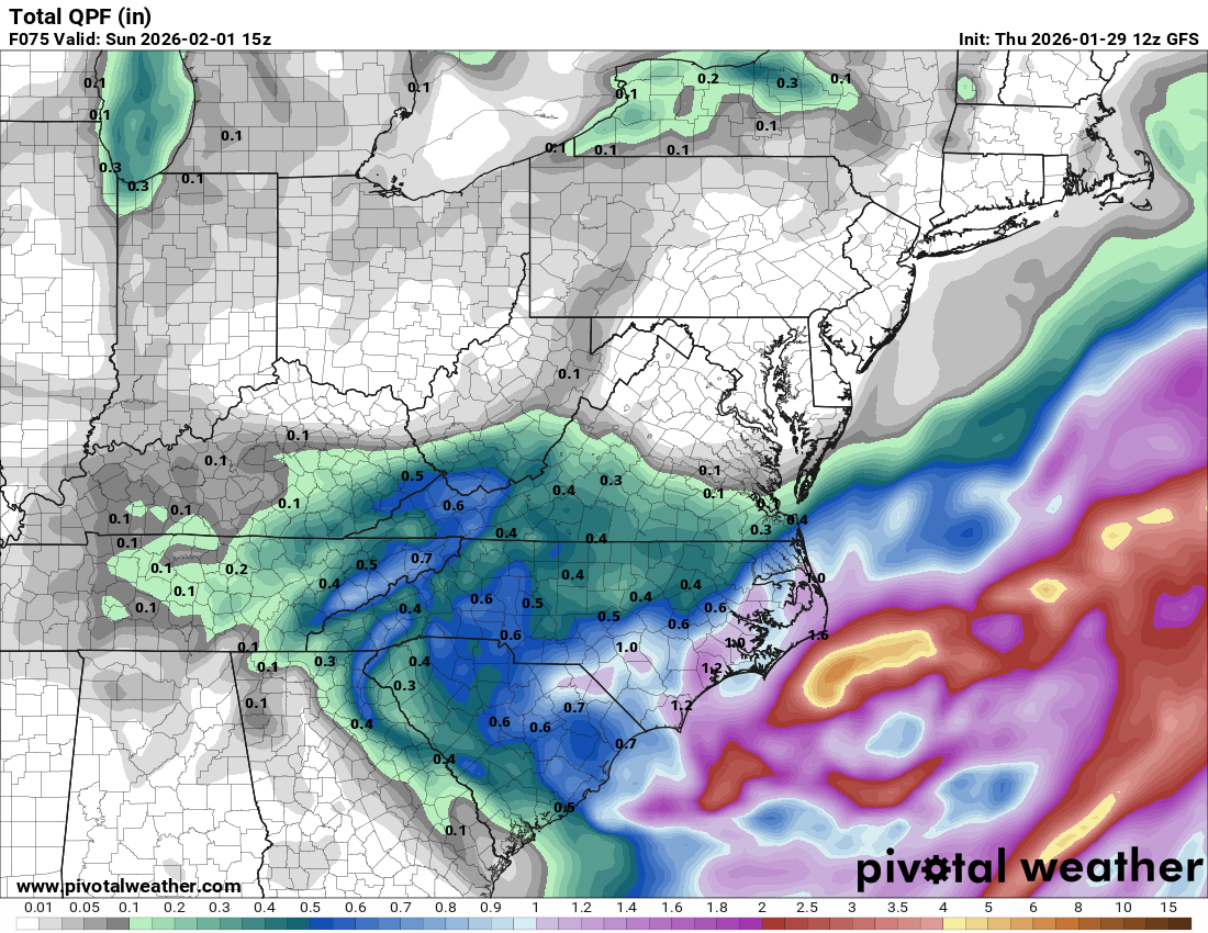
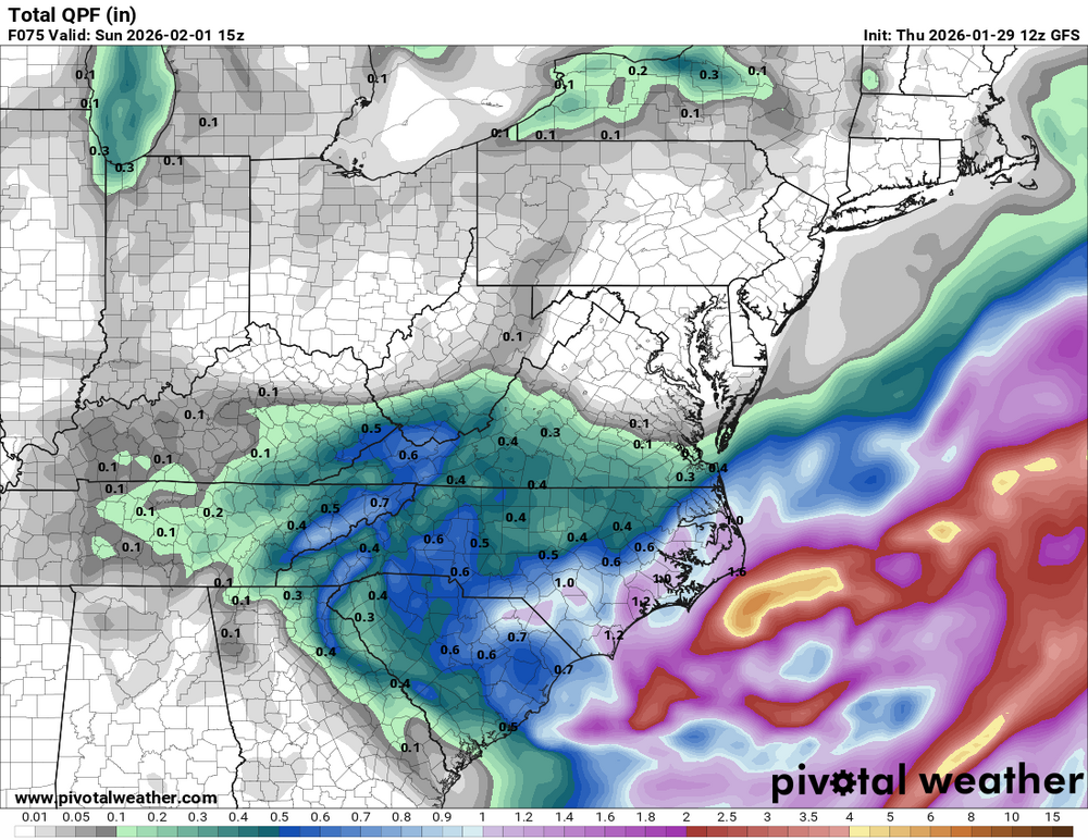
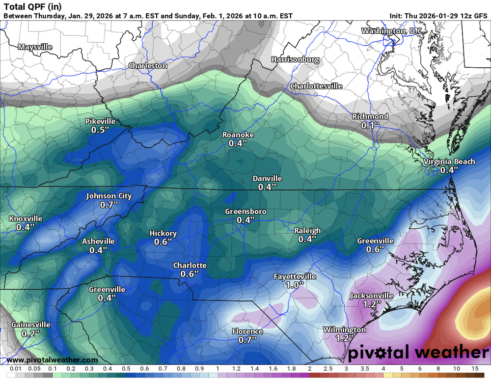
Directly over Raleigh, yes, but that area in general just lost a ton of precip and that snow hole is creeping. Not specific runs just tends
-
Not saying I'm agreeing with the NAM, but we're getting into the zone for short range models and they may be picking up signs that the energy transfers to the coastal and skips central NC
-
Not a good trend for Raleigh and points West
-
Wow, you can even plot the data!
-
where do you pull this data from?
-
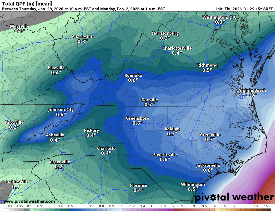
I think those of us between Lynchburg and Wytheville are literally in the boom or bust region. We could get .05" or .5" of precipitation. Given our ratios which I believe will be closer to 25-1 based on guidance, we're looking at the difference between 1" or 12". Most areas south of us are as close to a lock for .4-.7 as you can get. With 15-1 ratios you won't see the range of totals we might up here.
-
I was getting some work done at the school when it popped. We've been closed all week
-
add that to our glacier and we've got 10" on the ground
-
When we have the Euro and GFS looking very similar it helps. Add in the short range ensembles and the Global ensembles we're starting to see something
-
Sorry friends in GA, we should be posting regional maps
-
I'll take it!!
-
Because the thread goes through Virginia
-
The snow could already be on the ground correct?
-
https://www.facebook.com/100064823943364/posts/pfbid02QG8AzAYQNGpqe3V14Lt9zcDSfpQ1QyxYRc5pKqn17b5upmzVGjCr45QdQMijfh8Hl/?app=fbl Very good analysis from my amateur friends over at Blue Ridge Weather
-
Doesn't each area have their own Blizzard Criteria?
-
GEFS mean is a good 4" in upstate GA