winter_warlock
-
Posts
3,378 -
Joined
-
Last visited
Content Type
Profiles
Blogs
Forums
American Weather
Media Demo
Store
Gallery
Everything posted by winter_warlock
-

Jan Medium/Long Range Disco 2: Total Obliteration is Coming
winter_warlock replied to Jebman's topic in Mid Atlantic
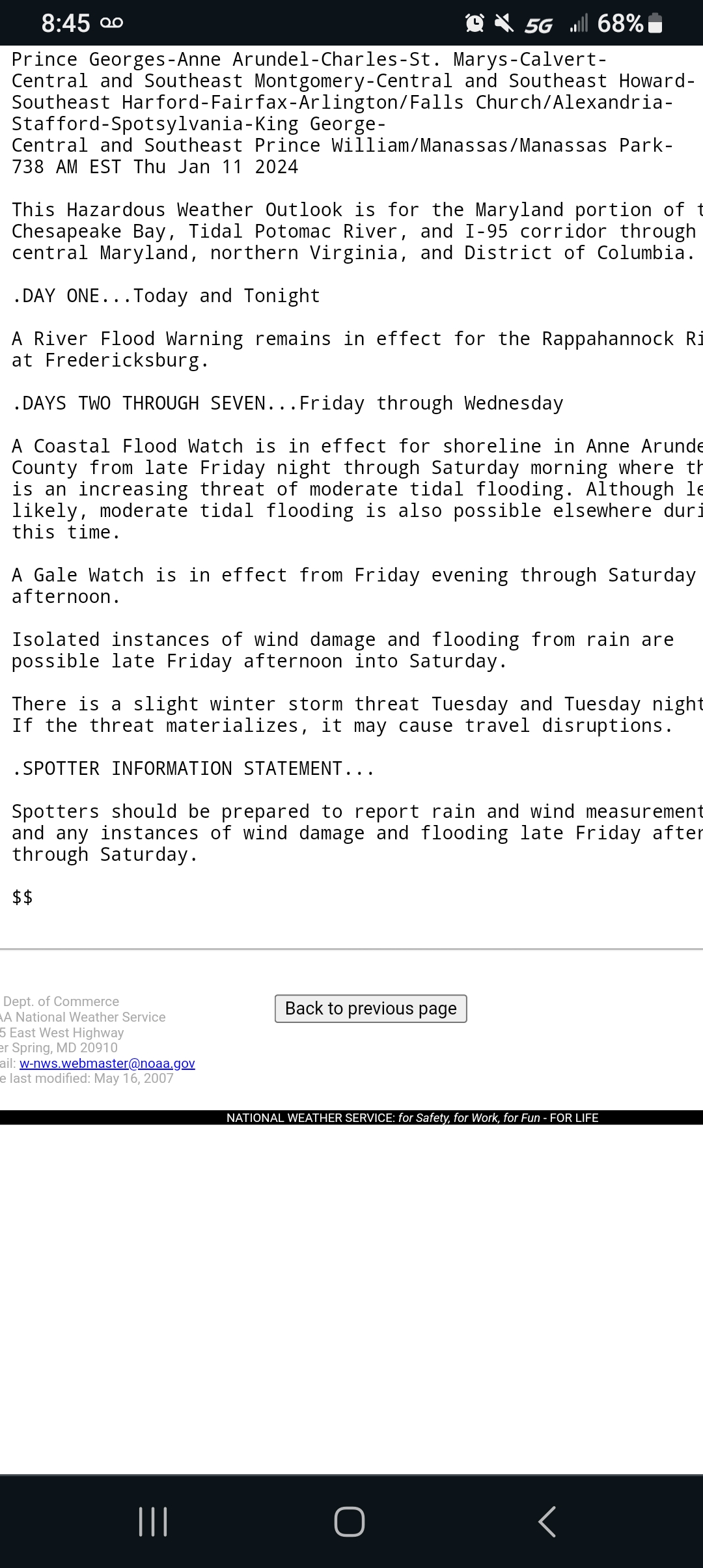
Sterling lwx. Included the jan 16th storm in their HWO. Fwiw...
-
Jan Medium/Long Range Disco 2: Total Obliteration is Coming
winter_warlock replied to Jebman's topic in Mid Atlantic
We need some good luck!! -
Jan Medium/Long Range Disco 2: Total Obliteration is Coming
winter_warlock replied to Jebman's topic in Mid Atlantic
Icon is like a drunk cousin, you dont always want him at family events, but when hes there, he can sometimes be entertaining lol -
Jan Medium/Long Range Disco 2: Total Obliteration is Coming
winter_warlock replied to Jebman's topic in Mid Atlantic
I couldnt remember either lol thats why i asked -
Jan Medium/Long Range Disco 2: Total Obliteration is Coming
winter_warlock replied to Jebman's topic in Mid Atlantic
So then the answer would be no lol -
Jan Medium/Long Range Disco 2: Total Obliteration is Coming
winter_warlock replied to Jebman's topic in Mid Atlantic
Were those models ever really all that accurate? Lol -
Jan Medium/Long Range Disco 2: Total Obliteration is Coming
winter_warlock replied to Jebman's topic in Mid Atlantic
Yup!!!! -
Jan Medium/Long Range Disco 2: Total Obliteration is Coming
winter_warlock replied to Jebman's topic in Mid Atlantic
Hey do any of you remember the CRAS model?? I wonder what happen to that dumpster fire of a model lol -
Jan Medium/Long Range Disco 2: Total Obliteration is Coming
winter_warlock replied to Jebman's topic in Mid Atlantic
I think its in a decent spot for 230 hours out -
Jan Medium/Long Range Disco 2: Total Obliteration is Coming
winter_warlock replied to Jebman's topic in Mid Atlantic
yup pretty much lol
.jpeg.684309fd3f15c3f8f06b6dac0f261b10.jpeg)
-
Jan Medium/Long Range Disco 2: Total Obliteration is Coming
winter_warlock replied to Jebman's topic in Mid Atlantic
Id be more disappointed in the 18z gfs if it was alot closer than 6 days out lol -
Jan Medium/Long Range Disco 2: Total Obliteration is Coming
winter_warlock replied to Jebman's topic in Mid Atlantic
In my best pedro cerrano voice.... " it is VERY BAD to steal Jobu's rum.. very bad!!" -
Jan Medium/Long Range Disco 2: Total Obliteration is Coming
winter_warlock replied to Jebman's topic in Mid Atlantic
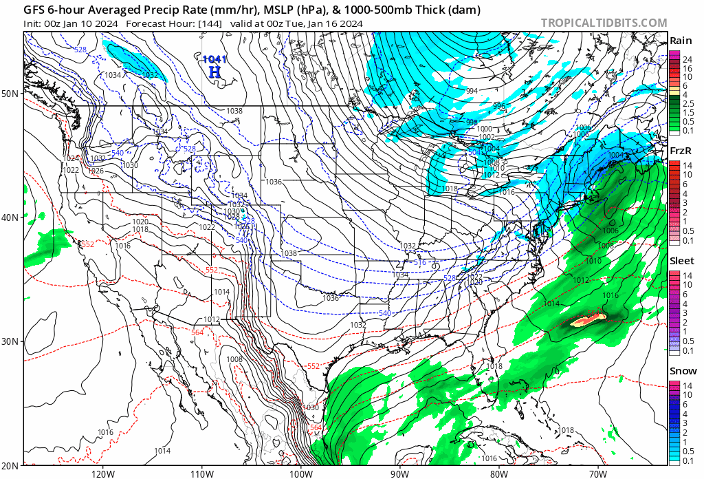
FWIW... HOUR 144 AND 168 of the JMA....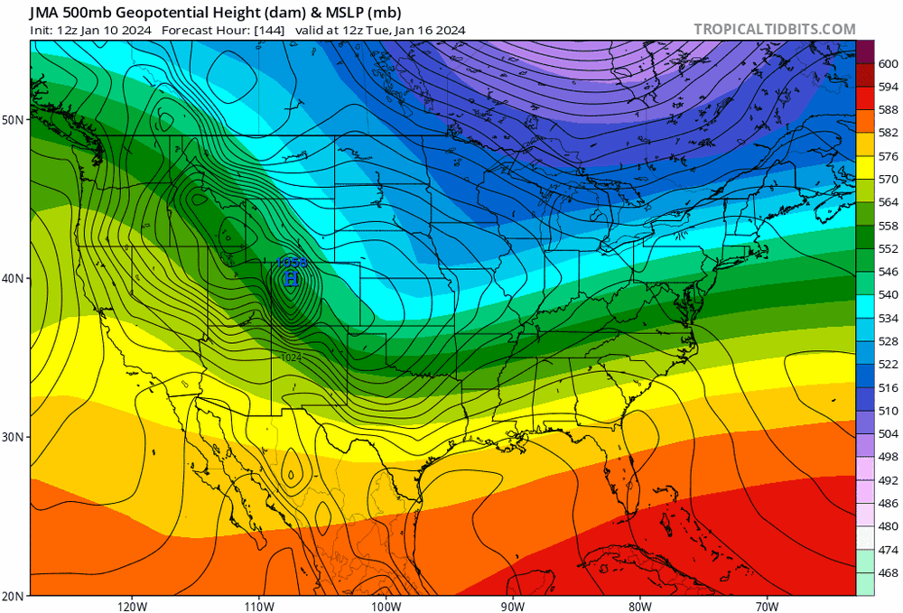
-
Jan Medium/Long Range Disco 2: Total Obliteration is Coming
winter_warlock replied to Jebman's topic in Mid Atlantic
Yeah lol it was actually the lowest amount ive ever had where i live now. -
Jan Medium/Long Range Disco 2: Total Obliteration is Coming
winter_warlock replied to Jebman's topic in Mid Atlantic
Well as long as i get more than the 2.5 inches i got last year. I'll call this winter a success lol -
Jan Medium/Long Range Disco 2: Total Obliteration is Coming
winter_warlock replied to Jebman's topic in Mid Atlantic
Definitely an improvement from. 00z!! In my opinion! -
Jan Medium/Long Range Disco 2: Total Obliteration is Coming
winter_warlock replied to Jebman's topic in Mid Atlantic
I agree. Step in right direction for 6 days out!! -
Jan Medium/Long Range Disco 2: Total Obliteration is Coming
winter_warlock replied to Jebman's topic in Mid Atlantic
After seeing the 12z gfs and cmc. Im thinking they may cave to what the euro had yesterday ! Was a good step in right direction! Woukd be nice to see the good ole days come back where the gfs and cmc caved to the king!!! -
Jan Medium/Long Range Disco 2: Total Obliteration is Coming
winter_warlock replied to Jebman's topic in Mid Atlantic
Agreed!! -
Jan Medium/Long Range Disco 2: Total Obliteration is Coming
winter_warlock replied to Jebman's topic in Mid Atlantic
I dont think they will really zero in on a solution till the second cutter goes thru. In my opinion -
Tuesday, January 9 Rain and Wind Storm
winter_warlock replied to Weather Will's topic in Mid Atlantic
I got a total of 1.71 inches of rain here in sparrows point MD -
Jan Medium/Long Range Disco 2: Total Obliteration is Coming
winter_warlock replied to Jebman's topic in Mid Atlantic
Thats all we can ask for 6 days out -
Jan Medium/Long Range Disco 2: Total Obliteration is Coming
winter_warlock replied to Jebman's topic in Mid Atlantic
Looks promising to me ill admit... but. Been many times its looked good 8+ days out only to change as we get closer -
Jan Medium/Long Range Disco 2: Total Obliteration is Coming
winter_warlock replied to Jebman's topic in Mid Atlantic
Looks very nice!!! Im hoping we can get a decent storm in this pattern Hate to see it be a waste!! -
Jan Medium/Long Range Disco 2: Total Obliteration is Coming
winter_warlock replied to Jebman's topic in Mid Atlantic
06z. Gfs is actually better then 00z to my untrained eye babysteps!