PeeDeeWx
-
Posts
37 -
Joined
-
Last visited
Content Type
Profiles
Blogs
Forums
American Weather
Media Demo
Store
Gallery
Everything posted by PeeDeeWx
-
January 30th- Feb 1st ULL and coastal storm obs
PeeDeeWx replied to JoshM's topic in Southeastern States
-
The “I bring the mojo” Jan 30-Feb 1 potential winter storm
PeeDeeWx replied to lilj4425's topic in Southeastern States
I believe ratios in SC were majorly overdone. It’s been light snow for 4+ hours in NE SC and we have an inch. Are heavier bands forecast to come through? I see no chance we get the 5” floor NWS predicted. -
The “I bring the mojo” Jan 30-Feb 1 potential winter storm
PeeDeeWx replied to lilj4425's topic in Southeastern States
Has the costal L really gotten going yet? -
The “I bring the mojo” Jan 30-Feb 1 potential winter storm
PeeDeeWx replied to lilj4425's topic in Southeastern States
What does this mean? You aren't talking dry when you say instability, correct? -
The “I bring the mojo” Jan 30-Feb 1 potential winter storm
PeeDeeWx replied to lilj4425's topic in Southeastern States
HRRR showing a meager .2 of qpf IMBY but a 6.5" snow Kuchera. Hmmm. That seems off. -
The “I bring the mojo” Jan 30-Feb 1 potential winter storm
PeeDeeWx replied to lilj4425's topic in Southeastern States
Great stuff. Seems the Mets would know this, right?? -
The “I bring the mojo” Jan 30-Feb 1 potential winter storm
PeeDeeWx replied to lilj4425's topic in Southeastern States
Can you dumb this down for me? Are you basically saying that the dry air shouldn’t be as egregious because it’s so cold the snow will form below it?? Thanks! -
The “I bring the mojo” Jan 30-Feb 1 potential winter storm
PeeDeeWx replied to lilj4425's topic in Southeastern States
Will short range models start picking up where dry slot will likely be? -
The “I bring the mojo” Jan 30-Feb 1 potential winter storm
PeeDeeWx replied to lilj4425's topic in Southeastern States
At this point, is it fair to say that most only need to worry about the dreaded dry slot set ups? -
The “I bring the mojo” Jan 30-Feb 1 potential winter storm
PeeDeeWx replied to lilj4425's topic in Southeastern States
This one feels different, no?? -
The “I bring the mojo” Jan 30-Feb 1 potential winter storm
PeeDeeWx replied to lilj4425's topic in Southeastern States
A lot of chatter from local Mets in Carolina’s about an influx of dry air. Is this not factored into modeling? -
The “I bring the mojo” Jan 30-Feb 1 potential winter storm
PeeDeeWx replied to lilj4425's topic in Southeastern States
Ok. Latching on to a tiny spot. But even at 3, dumpster fire? That’s pretty close to your annual snowfall, no? -
The “I bring the mojo” Jan 30-Feb 1 potential winter storm
PeeDeeWx replied to lilj4425's topic in Southeastern States
5”+ is a dumpster fire? -
The “I bring the mojo” Jan 30-Feb 1 potential winter storm
PeeDeeWx replied to lilj4425's topic in Southeastern States
Long story short, you are sitting pretty. -
The “I bring the mojo” Jan 30-Feb 1 potential winter storm
PeeDeeWx replied to lilj4425's topic in Southeastern States
3" of snow in the S is a snoozer? Interesting. -
The “I bring the mojo” Jan 30-Feb 1 potential winter storm
PeeDeeWx replied to lilj4425's topic in Southeastern States
Confused why folks are upset over the latest NAM?
-
The “I bring the mojo” Jan 30-Feb 1 potential winter storm
PeeDeeWx replied to lilj4425's topic in Southeastern States
Why is there a wiener in our snow thread? -
The “I bring the mojo” Jan 30-Feb 1 potential winter storm
PeeDeeWx replied to lilj4425's topic in Southeastern States
If Ukie wins out I'm moving to Aspen. -
The “I bring the mojo” Jan 30-Feb 1 potential winter storm
PeeDeeWx replied to lilj4425's topic in Southeastern States
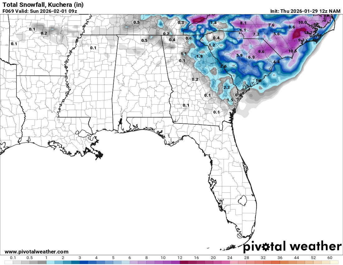
Is this 10:1? -
The “I bring the mojo” Jan 30-Feb 1 potential winter storm
PeeDeeWx replied to lilj4425's topic in Southeastern States
Brick is like fool me once shame on you, fool me 8768 times shame on me. Where is that guy!?!? -
The “I bring the mojo” Jan 30-Feb 1 potential winter storm
PeeDeeWx replied to lilj4425's topic in Southeastern States
They don’t go by these clown maps. If it continues to show, they’ll change their tune. -
The “I bring the mojo” Jan 30-Feb 1 potential winter storm
PeeDeeWx replied to lilj4425's topic in Southeastern States
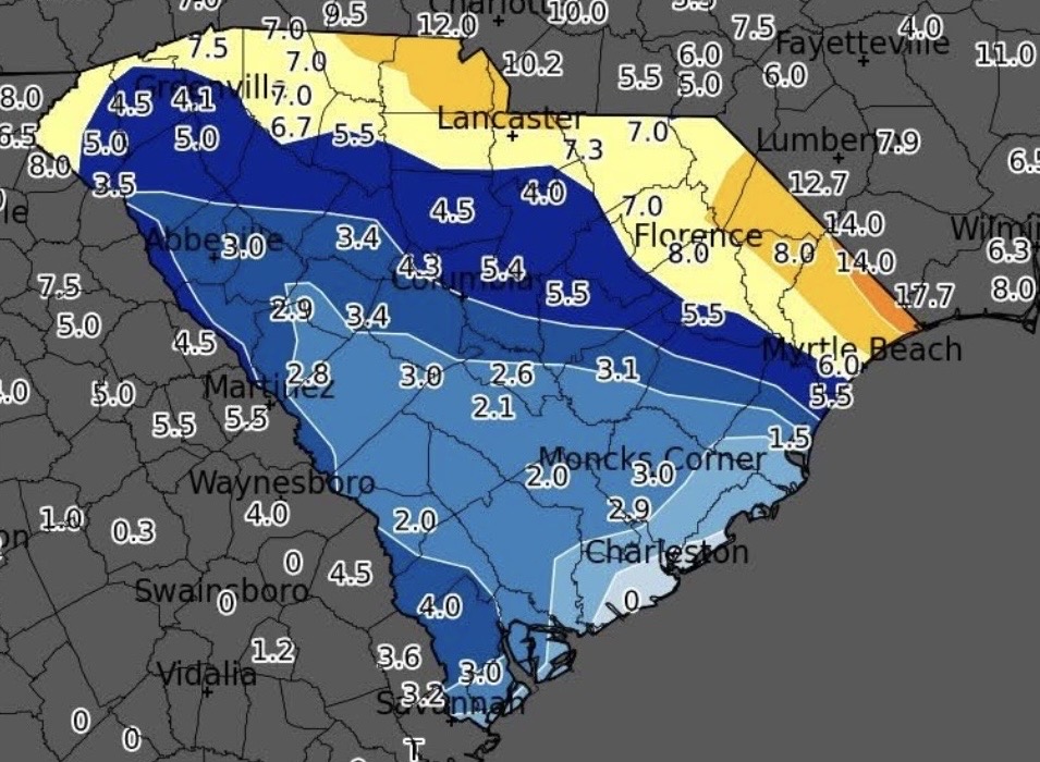
NAM did really well for my area last weekend. Better than the others. -
The “I bring the mojo” Jan 30-Feb 1 potential winter storm
PeeDeeWx replied to lilj4425's topic in Southeastern States
That’s 2+” of snow for most of Carolina’s. -
The “I bring the mojo” Jan 30-Feb 1 potential winter storm
PeeDeeWx replied to lilj4425's topic in Southeastern States
How did this model handle this past weekends storm? -
The “I bring the mojo” Jan 30-Feb 1 potential winter storm
PeeDeeWx replied to lilj4425's topic in Southeastern States
NAM did the best in my area. Especially with QPF.