
KChuck
-
Posts
414 -
Joined
-
Last visited
Content Type
Profiles
Blogs
Forums
American Weather
Media Demo
Store
Gallery
Posts posted by KChuck
-
-
21 minutes ago, GaWx said:
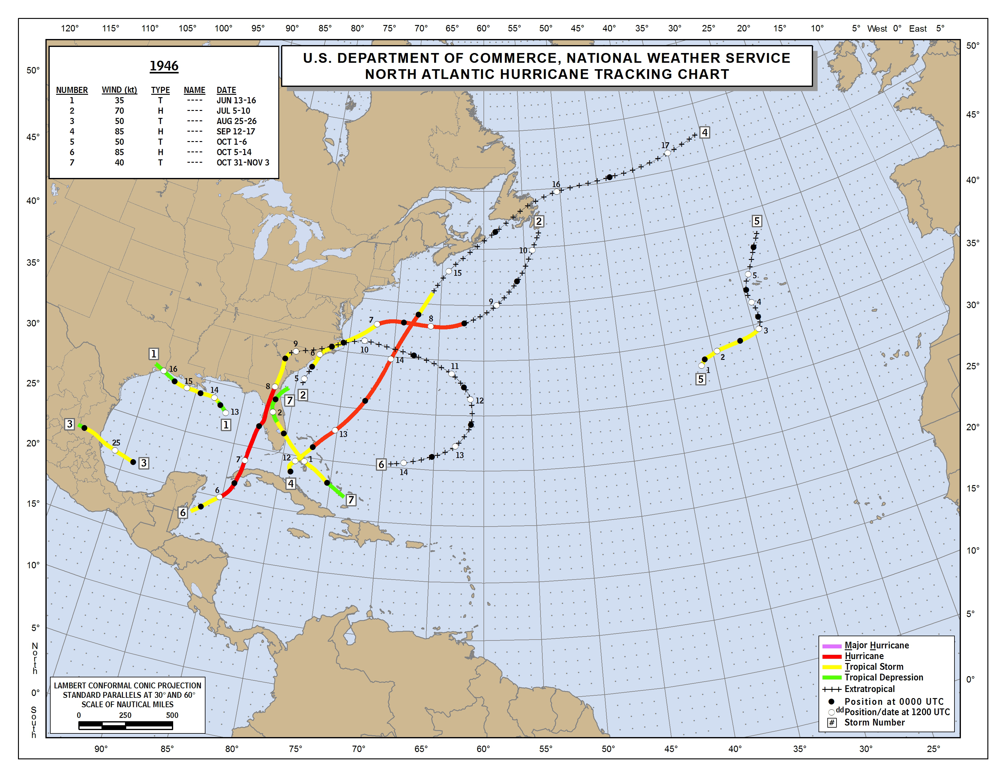
1. Tampa's last direct hit off the Gulf by a hurricane was way back in 1946. I don't know what the surge was at Tampa:
2. Alma of 1966, which paralleled the FL w coast, produced wind gusts to 93 mph in the Tampa area. New Port Richey to the north had a storm tide of 10 feet. I don't know what Tampa had:
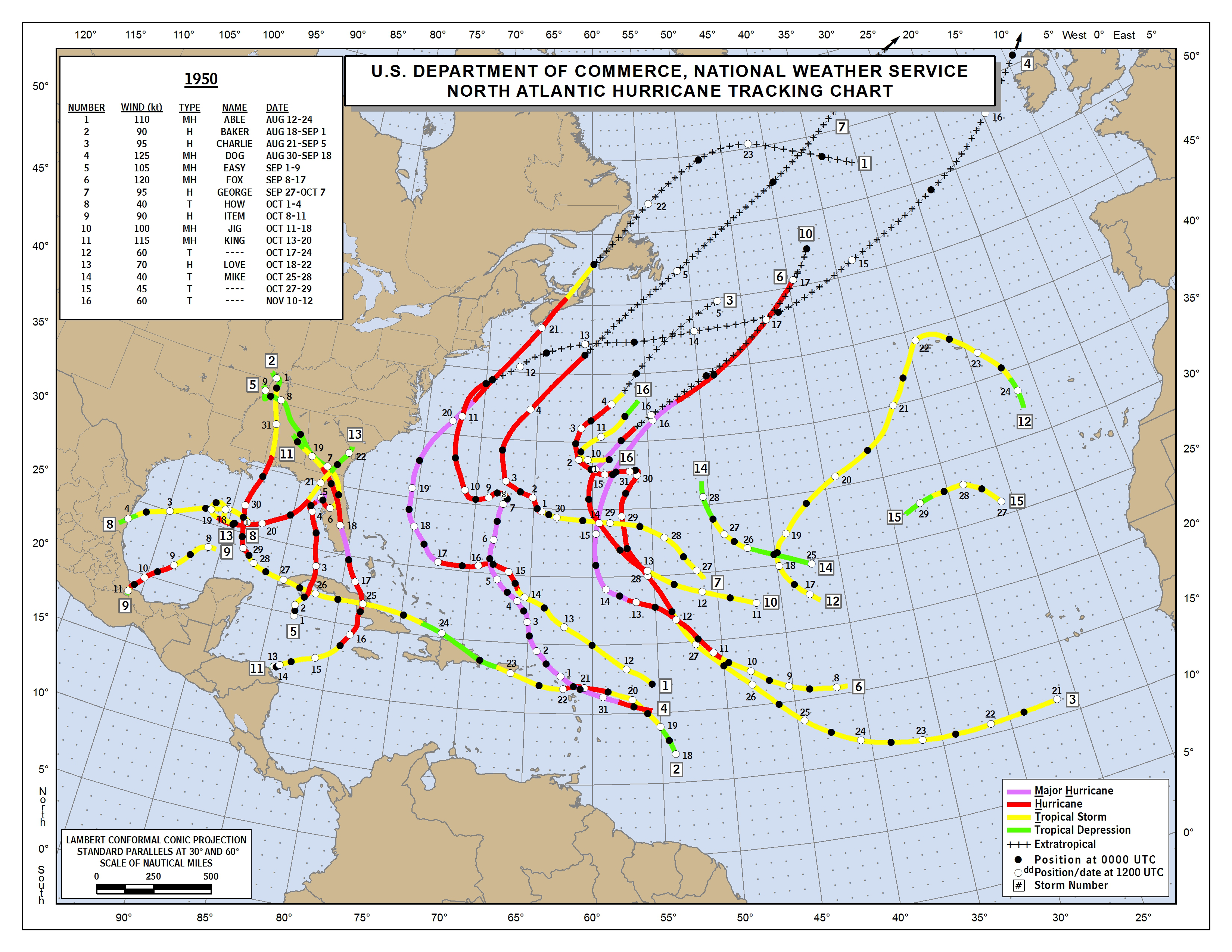
3. Easy of 1950 produced a surge of 6.5 feet at Tampa Bay, the highest then since 1921 per Wikipedia. It just missed a direct hit on Tampa as it looped, but it still produced severe damage there:
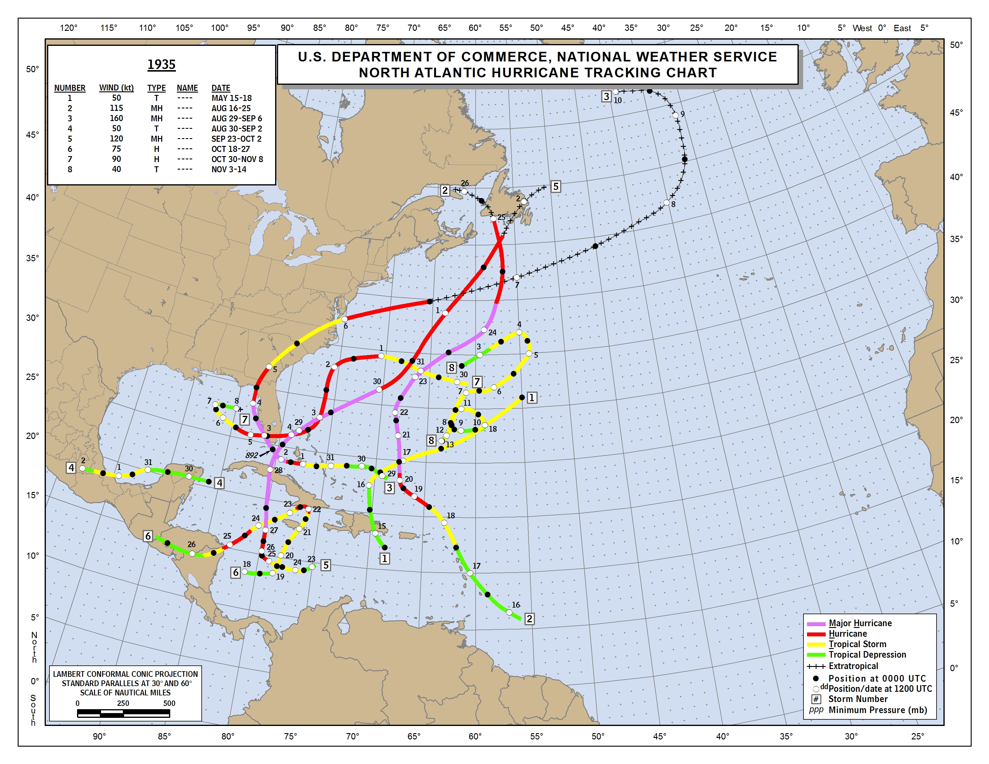
4. The 1935 hurricane passed just enough offshore Tampa to cause 75 mph winds and a storm surge of 5.3 feet:
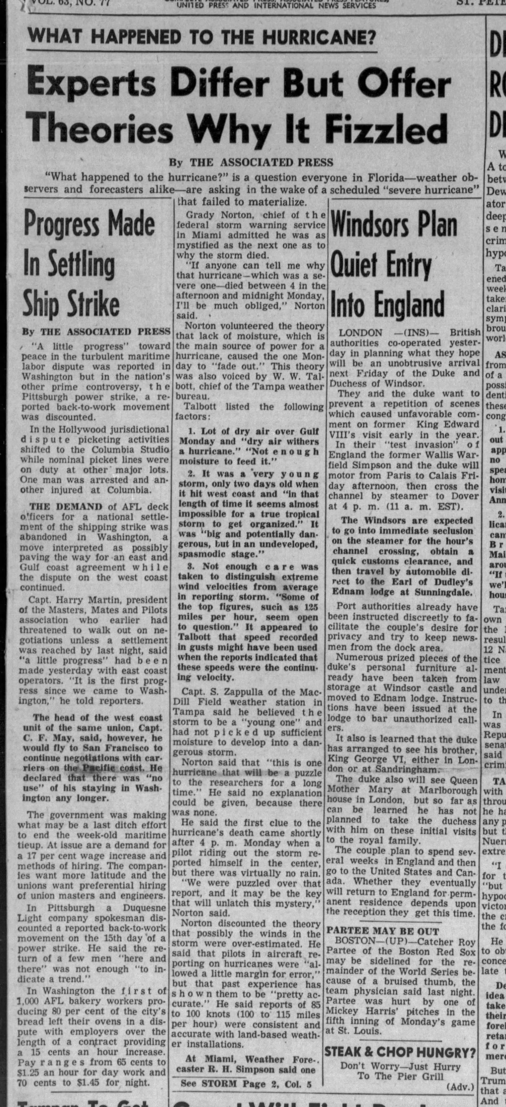
I looked up the 1946 hurricane in the newspaper archives. You're not going to believe it. I'll let you read for yourselves.
CLIPPED FROM
Tampa Bay Times
St. Petersburg, Florida
09 Oct 1946, Wed • Page 1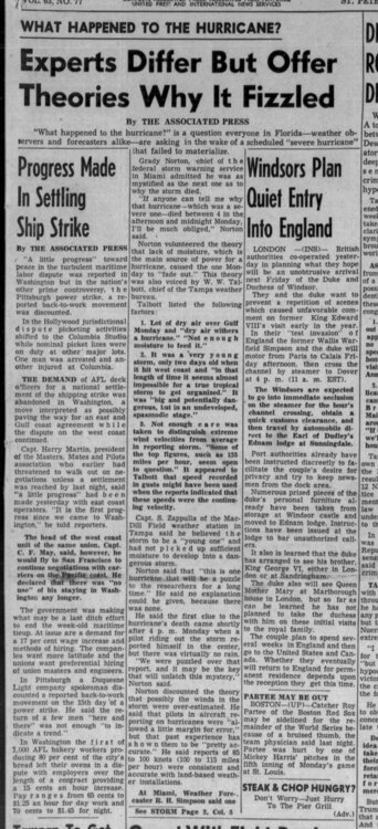
-
 5
5
-
-
7 minutes ago, Dbullsfan22 said:
Anyone within 100 miles of Tampa shouldn’t be shocked this is gonna maybe hit the OBx r miss Fl completely. Nothing ever comes near Tampa…ever
My mom and dad moved there when my dad retired after 46 years with Sears, the last bunch being a regional manager. He did extensive interviews and research as to the safest place in Florida from hurricanes. Everyone said the Tampa area so he bought property and had a home built on the edge of Spring Hill. He chose Florida as being free from income taxes and plenty of good places to golf. Mom wasn't as happy moving from Pennsylvania and children and grandchildren.
-
14 minutes ago, Ed, snow and hurricane fan said:
I told him to be happy if August winds up 0/0/0 and take the rare win.
A broken clock is correct twice a day. Also a blind squirrel finds a nut every now and then.
-
2
-
-
1 hour ago, SnoSki14 said:
Lmao what. JB is one of the worst forecasters ever. He says the same thing every year so sure eventually something will stick.
He also called for global cooling in the 2010s, talk about a miss. He's a major climate change denier or skeptic as well.
A blind squirrel finds a nut now and then!
A broken clock is right twice a day.
etc. etc.
-
From the news release:
QuoteToday, NOAA inaugurated the nation’s newest weather and climate supercomputers with an operational run of the National Blend of Models. The new supercomputers, first announced in February 2020 with a contract award to General Dynamics Information Technology (GDIT), provide a significant upgrade to computing capacity, storage space and interconnect speed of the nation’s Weather and Climate Operational Supercomputing System.
“Accurate weather and climate predictions are critical to informing public safety, supporting local economies, and addressing the threat of climate change,” said U.S. Secretary of Commerce Gina M. Raimondo. “Through strategic and sustained investments, the U.S. is reclaiming a global top spot in high-performance computing to provide more accurate and timely climate forecasts to the public.”
QuoteThe new supercomputers will enable an upgrade to the U.S. Global Forecast System (GFS) this fall and the launch of a new hurricane forecast model called the Hurricane Analysis and Forecast System (HAFS), slated to be in operation for the 2023 hurricane season pending tests and evaluation.
QuoteEach supercomputer operates at a speed of 12.1 petaflops, three times faster than NOAA’s former system.
Does this mean that the GFS model will be able to be wrong three times faster than before???

-
 1
1
-
-
Average southeast weather forum member's reaction if models don't go their way.

And members that have been on here a while...

And when everyone cashes in

-
7
-
-
-
6 hours ago, Jonathan said:
I believe the saying goes "close only counts in horseshoes, ATOMIC BOMBS, and hand grenades."
You forgot one.
-
Talk about feast or famine. We had 3.21" on Thursday the 11th and another .50" the day before on the 10th. Daughter who lives in Wallburg managed just over a tenth over the same two days. That's about some ten to twelve miles as the crow flies from us.

-
29.3 at 5am. Started the sprinklers on the grapevines at 2am to protect the young shoots just coming out.
-
29.3 at 5am. Started the sprinklers on the grapevines at 2am to protect the young shoots just coming out.
-
1
-
-
2 minutes ago, Tullioz said:
It doesn't do well in situations like today. For example, I have measured .59" with my Davis weather station, and only .06 with the tempest. The wind is probably off also due to the restricted air flow from ice, but I don't have anything to compare it to since my Davis station is frozen up.
Rain measurements have always been off with my Tempest station. Often more than 50% compared to my Davis and simple manual tube type rain gauge that I use.
You mean you don't go out on the hour to break up the ice like they do on Mt Washington?
-
2
-
3
-
-
34.0/26.0 four miles north of Kville.

-
1
-
-
9 minutes ago, kvegas-wx said:
Still stars and moon here in Kvegas just east of Winston. Breeze makes it quite a chilly evening. 35 and static electricity dewpoints. I think we got this one in our sights.
Just went out and put the covers on the car's side mirrors and windshield. I'm 5 miles north of Kville and wondering if I should have forced wife to bale out and gotten ourselves a hotel down south somewhere for the duration. Too much politics involved in marrying a farmer's daughter who was raised to tough things out
-
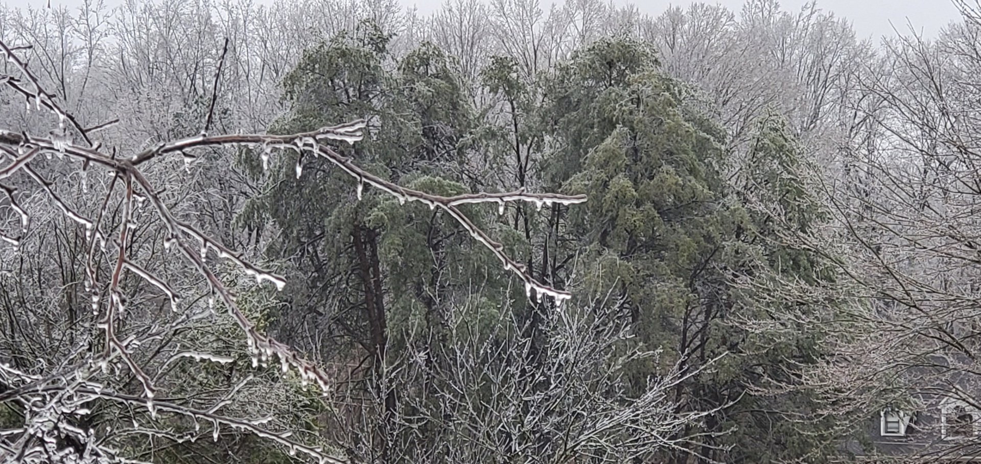
I'm curious about an observation I made coming home into Kville yesterday from Thomasville. Not much ice had accrued in the trees except where I was passing highways 311 and both 40s coming back 66 into Kville from the south. The trees at those ramps and along the interstates were pretty white with ice, where once you got away from the highways there was little. Curious as to thoughts as to why. Is it because of the air movement from the traffic, the topography where they cut into the land for the highways, or some other nefarious contribution? Just curious.
-
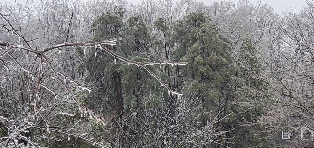
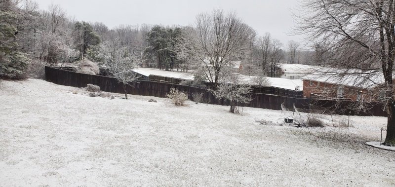
Ice increasing in Pine Knolls north of Kville. Ice on trees increased from minimal around 8am to this I just took.
-
3
-
-
Saw this on Twitter. Reminds me of this board to a certain extent. weathermen watching incoming weather on large screen
-
5
-
-
10 minutes ago, buckeyefan1 said:
 I don’t think I can remember a Miller A that gave severe weather to the upstate. If it happens, this year would be the icing on the cake
If the models forecasted it the way this year has gone, there'd be no icing!

-
3
-
-
Just now, tarheelwx said:
31.6. My deck looks to be covered in sleet here in Colfax about 5 miles from GSO. Did anyone else in the triad get sleet?
TW
I'm about 4 miles north of Kville. Just came back from checking outside. Light cold rain and no signs of ice on the car. There is some accumulated sleet at the bottom of the windshield so assume it's been a bit since it fell and rain had washed most away. Back deck just looks wet. 32.3/31.0
-
15 hours ago, lilj4425 said:
I almost ran over a squirrel today.

On the way to work this am I almost ran over a skunk!

-
-
Just doing general research into TPV's for self-education and came across this discussion link for current TPV events.
On the sudden stratospheric warming and polar vortex of early 2021
-
32.8/32.0 w light snow. Had .25" of rain that fell between 6 and 6:30 that dropped temp a degree to 32.7. Overall more snow than last weekend.
-
1
-
-
10 hours ago, WinstonSalemArlington said:
2015 was a long time ago
... and before COVID-19!


Hurricane Ian
in Tropical Headquarters
Posted
When the moon is at its full or new moon phase, high tides are at their highest, while low tides are lower than usual. Called spring tides, these tides occur when the sun, moon and the Earth all line up. Quoting eather Mike post 17 minutes after yours: