

Joe4alb
-
Posts
607 -
Joined
-
Last visited
Content Type
Profiles
Blogs
Forums
American Weather
Media Demo
Store
Gallery
Everything posted by Joe4alb
-
3" east end.... Based on the radar, gonna start dumping here soon
-

Extreme Cold, Snow & Sleet: SECS 1/24 - 1/26
Joe4alb replied to TriPol's topic in New York City Metro
Of course it is!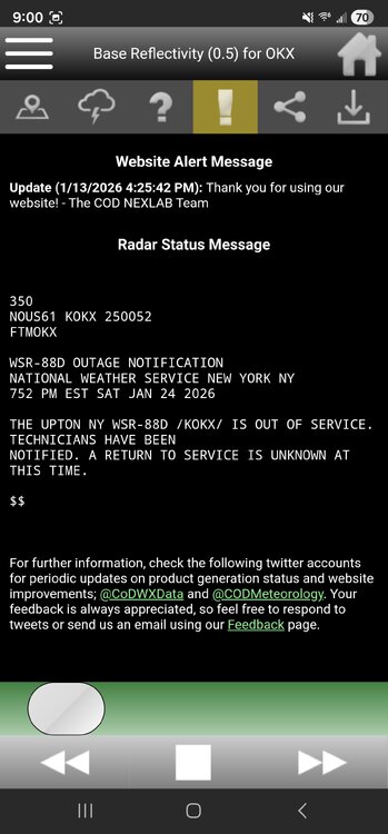
-
Extreme Cold, Snow & Sleet: SECS 1/24 - 1/26
Joe4alb replied to TriPol's topic in New York City Metro
not much change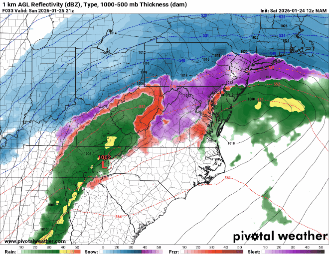
-
Extreme Cold, Snow & Sleet: SECS 1/24 - 1/26
Joe4alb replied to TriPol's topic in New York City Metro
so far so good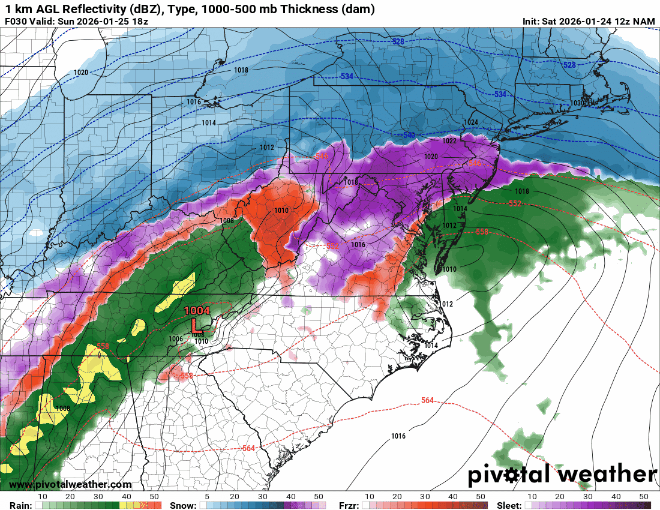
-
Extreme Cold, Snow & Sleet: SECS 1/24 - 1/26
Joe4alb replied to TriPol's topic in New York City Metro
yeah saw that, started colder then coastal was closer and ended warmer. -
Extreme Cold, Snow & Sleet: SECS 1/24 - 1/26
Joe4alb replied to TriPol's topic in New York City Metro
yeah started off colder with the primary being weaker, but with the coastal being a bit stronger and closer to the coast, we end up about the same. -
Extreme Cold, Snow & Sleet: SECS 1/24 - 1/26
Joe4alb replied to TriPol's topic in New York City Metro
HRRR coming in slightly colder -
Extreme Cold, Snow & Sleet: SECS 1/24 - 1/26
Joe4alb replied to TriPol's topic in New York City Metro
Regardless of what happens.... 1 - The heaviest snow is during the day so we actually get to see and enjoy it for once (always seems to happen overnight!) 2 - Good chance of thundersnow and insane banding Enjoy this one... should be a good show -
Extreme Cold, Snow & Sleet: SECS 1/24 - 1/26
Joe4alb replied to TriPol's topic in New York City Metro
NAM is considerably further north then the rest of the short range models. -
Extreme Cold, Snow & Sleet: SECS 1/24 - 1/26
Joe4alb replied to TriPol's topic in New York City Metro
Down to 19 here. Was 25 about an HR ago. -
Extreme Cold, Snow & Sleet: SECS 1/24 - 1/26
Joe4alb replied to TriPol's topic in New York City Metro
Looks to me like the ICON is holding the primary longer and stronger through 48hrs -
Extreme Cold, Snow & Sleet: SECS 1/24 - 1/26
Joe4alb replied to TriPol's topic in New York City Metro
Icons rolling, lets see if we can bat .000 for the 18z suite -
Extreme Cold, Snow & Sleet: SECS 1/24 - 1/26
Joe4alb replied to TriPol's topic in New York City Metro
Primary seems to be weaker, that to me is a good sign. -
Extreme Cold, Snow & Sleet: SECS 1/24 - 1/26
Joe4alb replied to TriPol's topic in New York City Metro
upper lvls on the nam show less ridging along the coast should hopefully lead to a faster transfer to the coastal low and prevent some of that mid-level warming -
doesn't appear phase will be clean on the 18z Nam, southern vort is hanging back more than previous runs.
-
Extreme Cold, Snow & Sleet: SECS 1/24 - 1/26
Joe4alb replied to TriPol's topic in New York City Metro
100% -
Extreme Cold, Snow & Sleet: SECS 1/24 - 1/26
Joe4alb replied to TriPol's topic in New York City Metro
actually considerable improvements in the upper levels on the Euro. 850 colder with a weaker low to our west. Good signs. -
Extreme Cold, Snow & Sleet: SECS 1/24 - 1/26
Joe4alb replied to TriPol's topic in New York City Metro
definitely appears like there will be less interaction here (I would post but I can't attach images larger than 133.77kb) -
Extreme Cold, Snow & Sleet: SECS 1/24 - 1/26
Joe4alb replied to TriPol's topic in New York City Metro
EURO-AI a bit more north, slightly warmer at 850. Not a big difference -
Extreme Cold, Snow & Sleet: SECS 1/24 - 1/26
Joe4alb replied to TriPol's topic in New York City Metro
As arctic high pressure drops out of Central Canada and into the Plains into Saturday, surface low pressure organizes across the Deep South with strong shortwave energy swinging east. The low is progged to move off the Carolina coast Saturday night or Sunday, passing nearby Sunday night into Monday. With help from reconnaissance data in the EPac, global ensemble systems and their respective AI counterparts continue to hone in on a more amplified, northern solution of the developing low pressure, leading to more moisture locally. Working in favor of the snow is the arctic air mass in place leading into the storm. 925 mb temps look to fall toward -20C or below on Saturday, with surface temperatures progged in the teens during the afternoon; likely one of the coldest days in several years. This will allow all snow to start very late Saturday night or Sunday morning as the associated WAA with the system gets into full swing. SLRs given the arctic profiles should be above 15:1 at least to begin, before gradually lowering through Sunday as the boundary slowly warms. Sunday appears to be when most of the snowfall and accumulation occurs. Depending on the ultimate track of the system, it remains possible enough warm air could materialize aloft near the coast to force mixing or a changeover, especially later Sunday or Sunday night. Of course, this would cut down on snow totals were it to occur, but also introduce icing concerns. This doesn`t appear to be the most likely solution at the moment however, with ensemble means putting the low somewhere near the 40N/70W benchmark, and not as far north as recent operational runs of the deterministic ECMWF and CMC. In line with WPC, total QPF through Monday sits around an inch for coastal areas, and closer to 0.75 inches inland. With an all snow event, or nearly so, this would produce a warning level snowfall across the local Tri State, with highest totals possibly eclipsing a foot. NBM v5.0 probabilities of at least 6 inches have consistently sat above 90 percent region-wide, and around 50 percent for at least a foot. Every single one of the 00Z Euro AIFS members yields a warning level (6 inch+) snowfall for NYC, an impressive signal at this stage. -
Extreme Cold, Snow & Sleet: SECS 1/24 - 1/26
Joe4alb replied to TriPol's topic in New York City Metro
-
Extreme Cold, Snow & Sleet: SECS 1/24 - 1/26
Joe4alb replied to TriPol's topic in New York City Metro
hoping the UKIE looks a bit better. 500 level seems to indicate northern stream lagging a bit compared to 6z, let's see if that leads to a bit less amplification. -
Extreme Cold, Snow & Sleet: SECS 1/24 - 1/26
Joe4alb replied to TriPol's topic in New York City Metro
CMC shows primary also weaker. -
Extreme Cold, Snow & Sleet: SECS 1/24 - 1/26
Joe4alb replied to TriPol's topic in New York City Metro
We have been struggling out here to see even better than advisory level snows over the past few years (only had about 2.5" on the snow last week). 6 - 8", sign me up. -
Extreme Cold, Snow & Sleet: SECS 1/24 - 1/26
Joe4alb replied to TriPol's topic in New York City Metro


