

TalcottWx
-
Posts
28,674 -
Joined
Content Type
Profiles
Blogs
Forums
American Weather
Media Demo
Store
Gallery
Posts posted by TalcottWx
-
-
1 hour ago, dendrite said:
Gotta love BDL
32.7 is my high temperature today in Simsbury , so far, and I am tickling back down. We have a quarter inch of ice. I don't have much experience with zr since I'm from coastal mass, but it appears to be a decent event considering over 25k have lost power. I'm curious to see what happens once the winds increase.
-
 1
1
-
-
1 minute ago, Sey-Mour Snow said:
Northern CT Will still have some ice accretion I’ll be above freezing by 11 or so
OK, cool. A little more ice then. I'm currently sitting at 29/27f.
-
1 hour ago, Sey-Mour Snow said:
HRRR has another 1"+ of qpf for CT wow.. an epic scene out there I havent seen since the 2000s.. Heavy snow pack and thick ice over it..
1 hour ago, CoastalWx said:31 almost in Tolland. Looks like the bigger accretion might be done in CT.
Are we done or not? Ice.. Confused
-
 1
1
-
-
1 hour ago, Damage In Tolland said:
What’s with the huge Dryslot in PA?
What about it?
-
2 minutes ago, Baroclinic Zone said:
Bordering on heavy in this band
Congratulations, Robert.
-
26 minutes ago, CT Rain said:
Ice could be significant in parts of NW CT and Farmington Valley tomorrow. That's a lot of QPF on the way.
Scooter said I would be tanning.
-
 1
1
-
-
2 hours ago, CoastalWx said:
This stuff is bonus stuff. After 9-10 we should see stuff strengthen a bit and move NE. I’m surprised I’m getting what I am getting now.
Not everything is about e mass, weenie.
-
24/26f here at in laws in Windsor, 3"
-
2 hours ago, Damage In Tolland said:
It feels like a snowy winter because we’ve barely seen grass . For me that goes a looonngg way . Not a rat
I could not agree more with this sentiment. This is what the season is supposed to feel like.
-
 2
2
-
-
2 hours ago, weathafella said:
3k is 12/16/07. Someone may be dumbfounded.
Great storm.
-
Great light snow about an hour ago. Patchy black ice after yesterday's rain. Our snow pack has become glacier-like after the recent storms.
-
14 minutes ago, HoarfrostHubb said:
You need to visit a rage room. You might enjoy it.
Just break out the shovel and snowblower. Beat it.
-
1
-
-
15 hours ago, klw said:
The Route 2 in Rhode Island or the Route 2 in Connecticut or the Route 2 in Mass or the Route 2 from the VT/NY border into Maine?
sorry it is a pet peeve of mine
No one cares about the one outside of mass, so you can just assume it's that one.
-
1
-
 5
5
-
1
-
 1
1
-
-
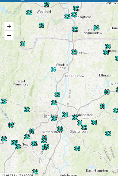
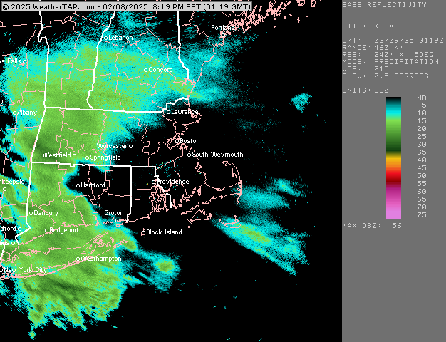
4" Simsbury; it's still snowing hard despite awful radar.
-
Radar is horrific.
-
24 minutes ago, Sey-Mour Snow said:
If that happens someone is def hitting double digits … not so sure it fills in though
I don't see it. I'm trying violently to see it.
-
1
-
-
I think some in CT lucky to see 3"
-
1 minute ago, ORH_wxman said:
It’s a little sucker hole but gonna start soon in CEF
Fill me, daddy
-
 1
1
-
-
2 hours ago, JC-CT said:
Imagine being in Cleveland or Akron and seeing this NAM run.


The NAM is the Mike Wankum of weather models; sun angle.
-
1
-
-
2 hours ago, Bryan63 said:
Congrats! Ours was scheduled to be a v day baby last year but decided to arrive early on the 10th.
Congrats to you also, on surviving/enjoying the 1st year. First? I haven't really taken her outside during a snowstorm yet, looking forward to it.
-
2
-
-
1 hour ago, Damage In Tolland said:
Appreciate keeping Tolland in the dong
Idk maybe he should move it just west of tolland
-
3 hours ago, wkd said:
Your first?
Yes, last winter during the storm. She turns 1 next week. V day baby
-
1
-
 1
1
-
-
1 hour ago, CoastalWx said:
Fuck that storm to hell
1/8 vis and puking aggregates while my wife suffers through birth and I stare out the window at Hartford Hospital.
-
1
-
-
2" at in laws in Windsor.
-
1
-

PD Holiday Weekend Mess DISCO
in New England
Posted
Do you ever stop whining