WeatherGeek2025
-
Posts
1,616 -
Joined
-
Last visited
Content Type
Profiles
Blogs
Forums
American Weather
Media Demo
Store
Gallery
Everything posted by WeatherGeek2025
-
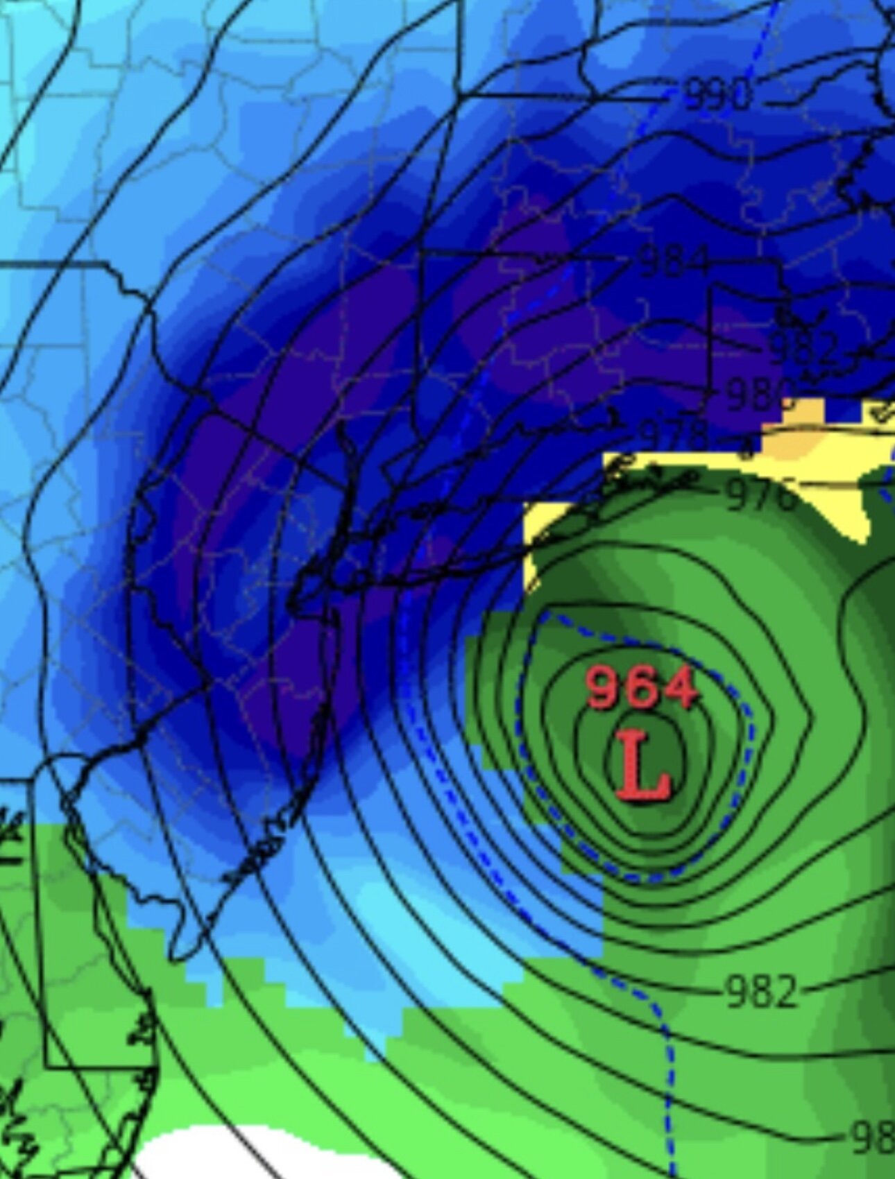
nam is going to tuck next run watch
-
-
you'll be fine, the flight will probably make it on time as the weather should start getting messy after 4pm or so
-
GFS is the best run yet. Blizzard all around
-
-
cmc loading
-
it held serve more or less good trend
-
-
i made a mistake im sorry!
-
nevermind it was photoshopped i took it off twitter My apologies I should've verified it
-
no it's not
-
The 0z GFS run is about to drop like it's the Super Bowl halftime show of winter—everyone's huddled around their screens at 10:40 PM EST, hearts pounding, praying this chaotic American model finally delivers the epic snowpocalypse we've been doom-scrolling about for days instead of yet another classic GFS fakeout where it teases a monster blizzard then ghosts us with rain and disappointment. Fingers crossed it verifies huge this time, because if it busts again, we're all just gonna go back to staring at the Euro like disappointed exes while whispering "why do we even trust you anymore?" to our weather apps. Come on, big boy, give the people what they want—two minutes until lift-off!
-
light snow by than
-
man that GFS run is going to be the run of this year in my opinion hopefully it doesn't disappoint!! exciting
-
can we see this LOW pressure tuck the coast more? What's stopping it from going more north? Nothing in my opinion this will only trend north! Luckily it's a strong storm so I don't think anyone should be worried about rain but only snow and a lot of wind!
-
-
that's all that matters euro ai came out way west is what missed
-
you okay? everybody okay?
-
euro ai snows from around 1pm sunday until 7pm monday!
-
i'm so happy the euro AI went north
-
hmmm to the weenies talking shit about the GFS
-
euro ai is a major hit!
-

Winter cancelled/uncancelled banter 25/26
WeatherGeek2025 replied to Rjay's topic in New York City Metro
You ever get a DM and you automatically know that person is a scammer because they call you dear? So you fuck around and string them along for days just to get them back! Karma is a bitch scammer! -
Winter cancelled/uncancelled banter 25/26
WeatherGeek2025 replied to Rjay's topic in New York City Metro
Tuck tuck tuck! Blizzard blizzard blizzard! Dc to Boston Dc to Boston Dc to Boston! -
it's verified before as an outlier it has i can confirm that!


