pawatch
-
Posts
3,287 -
Joined
-
Last visited
Content Type
Profiles
Blogs
Forums
American Weather
Media Demo
Store
Gallery
Everything posted by pawatch
-

Central PA Summer 2026 Discussion/Obs Thread
pawatch replied to Voyager's topic in Upstate New York/Pennsylvania
Looks like 1.79” today. -
Central PA Summer 2026 Discussion/Obs Thread
pawatch replied to Voyager's topic in Upstate New York/Pennsylvania
Picked up over an 1” of rain this morning and still light rain. Also looks like we will have more rain later on today. Much Needed! -
Central PA Summer 2026 Discussion/Obs Thread
pawatch replied to Voyager's topic in Upstate New York/Pennsylvania
We definitely need some rain. Lets hope their prediction is right. -
Central PA Summer 2026 Discussion/Obs Thread
pawatch replied to Voyager's topic in Upstate New York/Pennsylvania
54 degrees this morning. Enjoy the weekend! -
Central PA Summer 2026 Discussion/Obs Thread
pawatch replied to Voyager's topic in Upstate New York/Pennsylvania
48 degrees again this morning. Wow! Voyager you sure got that low down on your weather station.Impressive! -
Central PA Summer 2026 Discussion/Obs Thread
pawatch replied to Voyager's topic in Upstate New York/Pennsylvania
Did the wind have anything to do with it failing? Only good thing is at least we are having cool weather and less humidity for cleanup. -
Central PA Summer 2026 Discussion/Obs Thread
pawatch replied to Voyager's topic in Upstate New York/Pennsylvania
48 degrees this morning. Maybe start the day in jeans -
Central PA Summer 2026 Discussion/Obs Thread
pawatch replied to Voyager's topic in Upstate New York/Pennsylvania
65 degrees this morning. Yesterday was a big disappointment for rainfall. As much as they was warning everyone of severe weather. .20” was all I got. The 2nd storm the radar just dissipated, and we didn’t even get a trace of rain. The river they went from predicting a crest of around 6’ to the river cresting below 3’. Currently a 1.46 deficit of rain for the month of July. June was even worse. -
Central PA Summer 2026 Discussion/Obs Thread
pawatch replied to Voyager's topic in Upstate New York/Pennsylvania
Picked up .20” off the first line of storms. A little lightning and thunder but not much. 2nd round of storms 1 hour or two? -
Central PA Summer 2026 Discussion/Obs Thread
pawatch replied to Voyager's topic in Upstate New York/Pennsylvania
66 degrees for the low. Fishing got canceled this morning because of the threat of severe weather. It was supposed to be rain showers this morning. But the sun is shining heating things up. -
Central PA Summer 2026 Discussion/Obs Thread
pawatch replied to Voyager's topic in Upstate New York/Pennsylvania
54 degrees this morning. Awesome morning! Anyone have an idea when this storms are supposed to start up tomorrow? -
Central PA Summer 2026 Discussion/Obs Thread
pawatch replied to Voyager's topic in Upstate New York/Pennsylvania
My USGS gauge is about 5-7 miles from my house. So the totals are almost never the same. Maybe get a Stratus manual rain gauge and compare that way. Definitely a nice day! -
Central PA Summer 2026 Discussion/Obs Thread
pawatch replied to Voyager's topic in Upstate New York/Pennsylvania
65 degrees this morning…Little bit better day! I picked up .43” of rain yesterday, we lucked out on the wind. We didn’t hardly have any of that. The highest wind gust was 20 miles an hour. There was a whole lot of thunder and lightning. I got mow number 18 in for the year yesterday, before the rain yesterday. -
Central PA Summer 2026 Discussion/Obs Thread
pawatch replied to Voyager's topic in Upstate New York/Pennsylvania
.40” of rain so far today. Currently thunder and the radar looks pretty robust heading my way. edit: looks south now Voyager the king for today! -
Central PA Summer 2026 Discussion/Obs Thread
pawatch replied to Voyager's topic in Upstate New York/Pennsylvania
64 degrees this morning Radar kind of looks spread out. -
Central PA Summer 2026 Discussion/Obs Thread
pawatch replied to Voyager's topic in Upstate New York/Pennsylvania
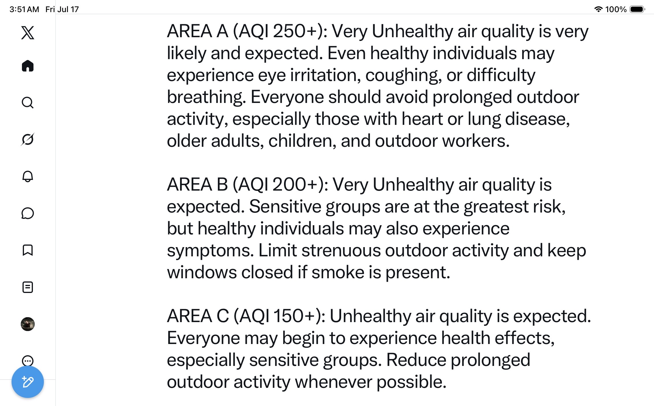
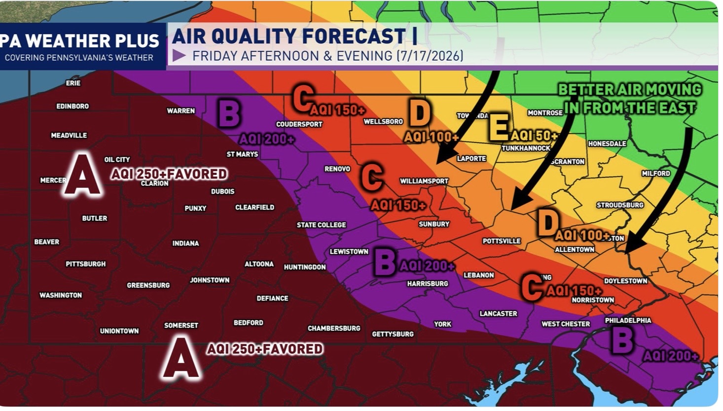
59 degrees this morning Looks like another day of smoke

-
Central PA Summer 2026 Discussion/Obs Thread
pawatch replied to Voyager's topic in Upstate New York/Pennsylvania
70 degrees this morning. DP 69 Looks like the 90’s today for the high. Only made it to 97 yesterday. Missed a line of thunder storms. -
Central PA Summer 2026 Discussion/Obs Thread
pawatch replied to Voyager's topic in Upstate New York/Pennsylvania
68 degrees this morning. Looks like a chance at hitting 100 today. My fishing yesterday I missed 3rd place by a couple ounces. 16 boats yesterday. It was a hot one! -
Central PA Summer 2026 Discussion/Obs Thread
pawatch replied to Voyager's topic in Upstate New York/Pennsylvania
64 degrees this morning. Getting ready to head fishing. AC system will be getting the legs workout these next couple days Isn’t legs the heavy day of the workout? -
Central PA Summer 2026 Discussion/Obs Thread
pawatch replied to Voyager's topic in Upstate New York/Pennsylvania
Sunday I was down to 60. This morning I was a little surprised it only made to 64. Weather and temperatures have been all over the place. -
Central PA Summer 2026 Discussion/Obs Thread
pawatch replied to Voyager's topic in Upstate New York/Pennsylvania
64 degrees this morning! -
Central PA Summer 2026 Discussion/Obs Thread
pawatch replied to Voyager's topic in Upstate New York/Pennsylvania
60 degrees pleasant morning! -
Central PA Summer 2026 Discussion/Obs Thread
pawatch replied to Voyager's topic in Upstate New York/Pennsylvania
I complained and picked up .28” of much needed rain -
Central PA Summer 2026 Discussion/Obs Thread
pawatch replied to Voyager's topic in Upstate New York/Pennsylvania
They are forecasting 98 degrees on Tuesday. That’s still pretty warm. I would be happy if we didn’t set anymore heat records. -
Central PA Summer 2026 Discussion/Obs Thread
pawatch replied to Voyager's topic in Upstate New York/Pennsylvania
66 degrees for the low. No rain yesterday The lack of rain in June really hurt us. - 3.36” Lately it is hard to get some decent rain. Either North/South of us, or else the radar dissipates before it gets to us. July we’re down and inch of rain so far for the month,