

SnowHabit
-
Posts
11 -
Joined
About SnowHabit

-
The “I bring the mojo” Jan 30-Feb 1 potential winter storm
SnowHabit replied to lilj4425's topic in Southeastern States
Very light and scattered flurries have started falling here on Fort Bragg, NC. -
The “I bring the mojo” Jan 30-Feb 1 potential winter storm
SnowHabit replied to lilj4425's topic in Southeastern States
When a commenter asked about the lower totals on the WRAL map than those included in the Winter Storm Watch, WRAL’s Grant Skinner responded: ”Very good question! We decided to go more conservative with the totals since there’s still model uncertainty. Our team talked about the latest model guidance and overall pattern yesterday and early this morning. It’s not clear where a heavier band of snow will set up. It’s just a first look; we’d rather trend higher if needed than say a bunch of snow and then not have near as much.” -
The “I bring the mojo” Jan 30-Feb 1 potential winter storm
SnowHabit replied to lilj4425's topic in Southeastern States
Winter Storm Watch issued just before 3am…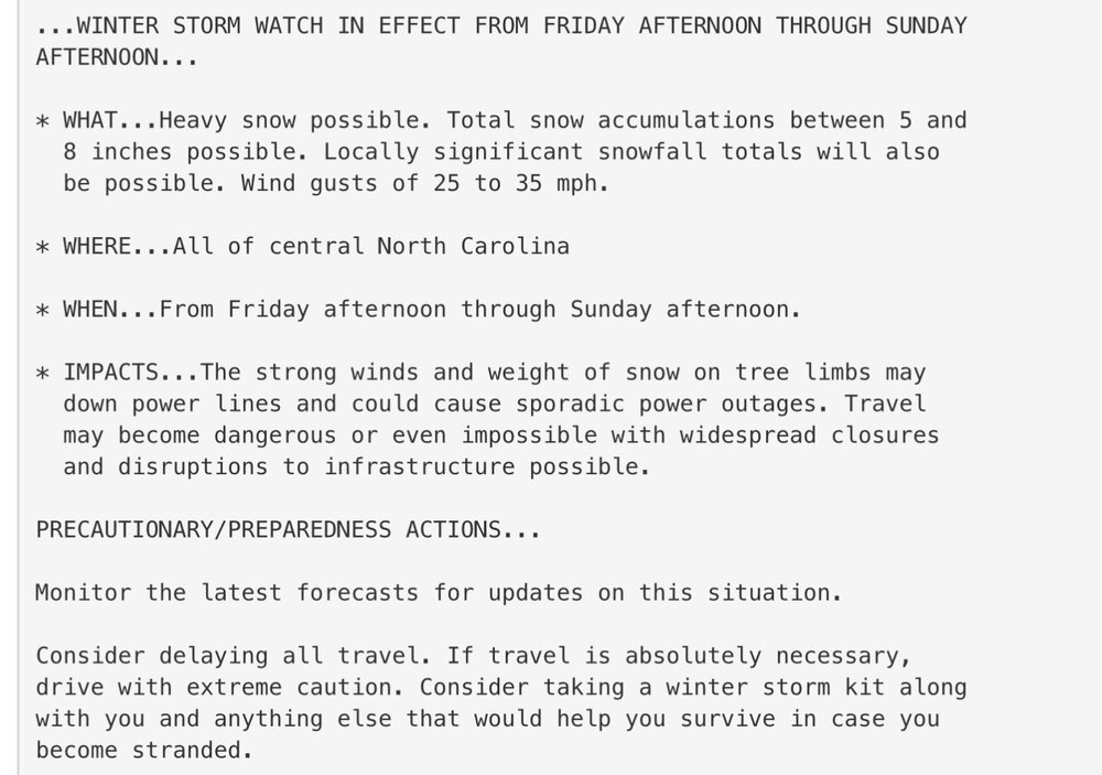
-
Same feeling here… I’m down in the Fayetteville area and hoping for just a few inches. Sent from my iPad using Tapatalk
-
Steady snow has started back up near Shannon Airport / Fredericksburg. Sent from my iPad using Tapatalk
-
… and now light snow very close to Shannon Airport / Fredericksburg. Sent from my iPad using Tapatalk
-
That’s good to know… Nothing here yet. I’m a few miles from Central Park and very close to Shannon Airport. Sent from my iPad using Tapatalk
-
January Medium/Long Range: A snowy January ahead?
SnowHabit replied to mappy's topic in Mid Atlantic
Capital Weather Gang on Facebook: “Snow potential index — 10/10 (→): Monday’s snow is a lock. The wild card is what next weekend could bring.” Sent from my iPad using Tapatalk -
Radar is now showing snow above us here in Fredericksburg… Nothing reaching the ground yet. Sent from my iPad using Tapatalk
-
OPM has announced that Federal Offices in the DC area are closed on Monday. Sent from my iPad using Tapatalk
-
Spotsylvania County, VA closed tomorrow… offices, facilities, courts, and schools.


