

JFLETCHER
-
Posts
14 -
Joined
-
Last visited
Content Type
Profiles
Blogs
Forums
American Weather
Media Demo
Store
Gallery
Posts posted by JFLETCHER
-
-
54 minutes ago, RIC Airport said:
Yeah, I'm monitoring. I won't be leaving until 6pm or 7pm if I even leave at all. I have a ton of things to do this weekend so going up will set me back so it's also something I'm weighing.
Caroline may not get much now from the way it looks.
-
 1
1
-
-
7 hours ago, wasnow215 said:
No golf at Pendleton in Ladysmith Saturday haha! Great course!
That is where I live.
-
7 minutes ago, RVAman said:
Yeah, pretty much. I knew this one wasn't gonna do much for us. I'd be surprised if even 30 miles N of Richmond getm uch
Agree. Best snow may be north of Fredericksburg from the way it looks now. I'm expecting maybe an inch up here in western Caroline. Models trending more north. Mountains may eat up some of our qpf too.
-
 2
2
-
-
4 minutes ago, RIC Airport said:
12z GFS is back north for 2/18/ to 2/19. This will continue to fluctuate since it's so far out. The last 10 days of the month are still the window. There are different pieces of energy around, and who knows which one will even be the storm.

I think that is the one to watch. Not taking it verbatim. But for a while, Presidents Day weekend through the end of February has been the timeframe for potential storms. I like the look for now, just continue to monitor.
-
30 minutes ago, RIC Airport said:
Yup, and new hits popped up on the 12z EPS. Hopefully, these charts light up in the coming days.


Today the LR looks good. Obviously, we don't want to take into account actual model runs, but primarily ensembles. Gotta say from Presidents Day through early March, I think we can score. What I would love is a good ole fashioned Miller A to come right up the coast and get us all in the action. Please no Miller Bs-they screw us 9 out of 10 times at our latitude unless the transfer happens in TN. I'm excited about this timeframe, just have to be patient.
-
2
-
-
17 minutes ago, RVAman said:
I hope we feast and DC doesn't. Since we aren't a "snow climate".
10-4 on that Sir.
-
1 hour ago, RIC Airport said:
@ldub23why do you keep posting the 384hr GFS and using that as justification to inject negativity into the thread? I've told you numerous times, both publicly and privately about why this isn't a best practice and you keep doing it.
The STJ has been producing all winter, hence the record rainfall we've seen since the week before Thanksgiving. The STJ isn't the issue. There are other mechanisms to learn about before making such declaration.
I also don't think people are "buying in", many of us have been at this long enough to know how things work. Personally, if I didn't want to see what the models showed a week or two in advance, I wouldn't be a part of this community and would either look at the forecast on my phone app or simply look out the window every day to see how the weather is. But, that isn't fun.
I wasn't trying to be rude or anything. I truly appreciate all of the posts you are making. I was just referring to the models in general and how poor they have been as of late. Do I think there is a good pattern coming, I do. I just hope that we can all feast down here in Central Virginia and get a good one to go our way.
-
1
-
-
35 minutes ago, ldub23 said:
Pattern change better get going. Virtually no snow in the eastern 2/3rd of the nation

Good call. I'm very skeptical of this "epic" pattern. You can have the setup all you want but if the STJ isn't producing, you may get a minor event here or there. But the models keep teasing folks and some keep buying in.
-
1
-
-
23 minutes ago, RIC Airport said:
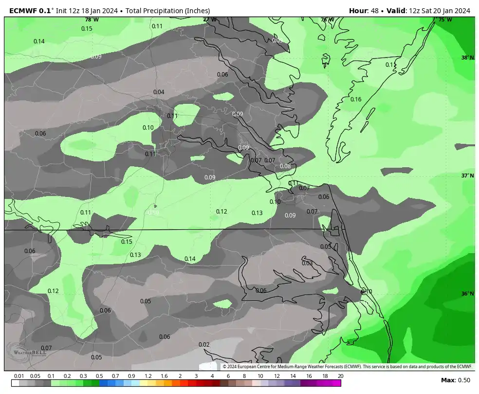
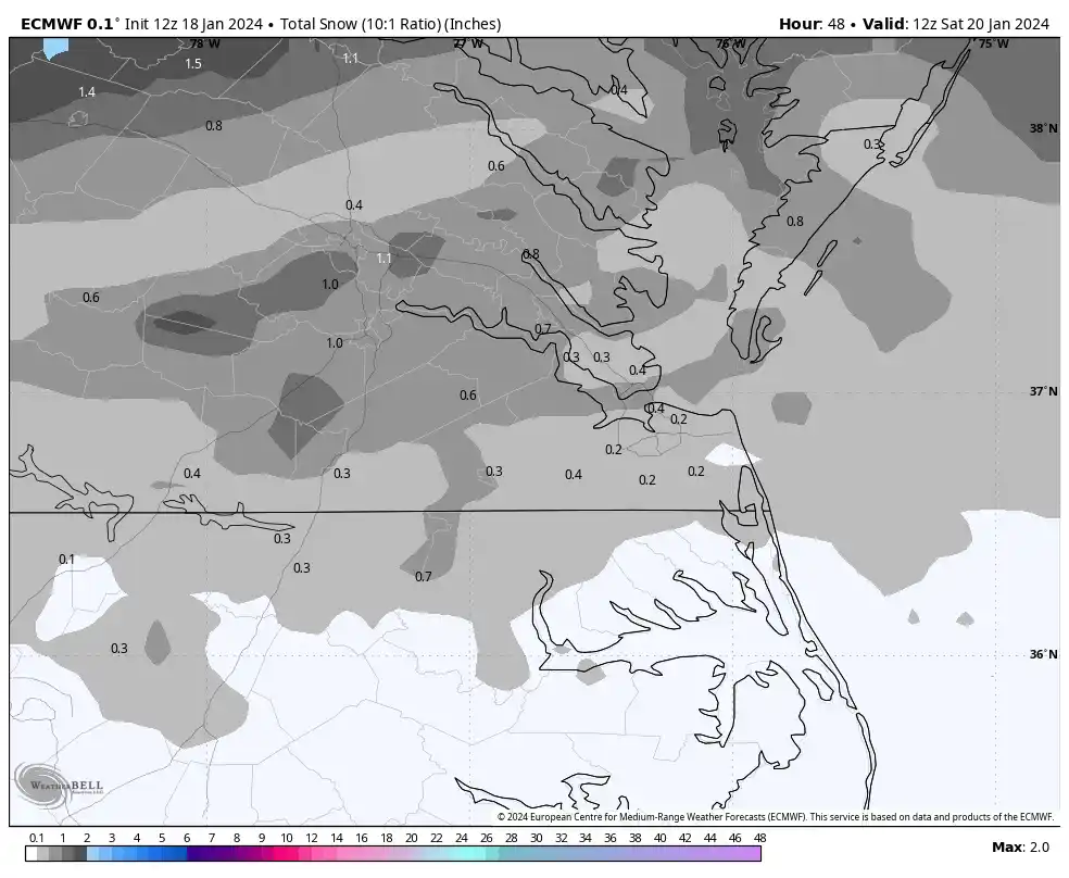
@RVAman, @eaglesin2011The 12Z Euro was actually similar to the GFS and tries to put a heavier band of snow between 4am and 10am over the Richmond metro area. But, challenges with respect to QPF amounts and surface temperatures remain. Interestingly, the Euro does have RIC right at freezing from 7am to 9am so that would increase the odds of getting that coating to half inch in more areas if this is correct.
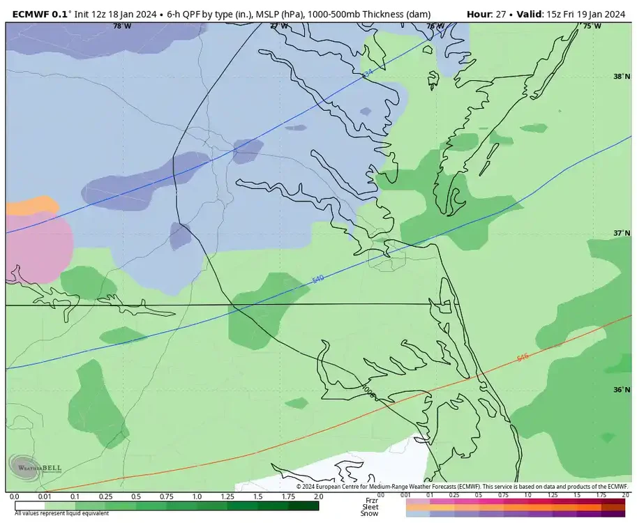

Maybe western caroline can get a half-inch to an inch up here.
-
2
-
-
6 minutes ago, Sernest14 said:
Finally some flakes in ashland. Looks like it should stay snow for a bit and pick up based on radar
I'm in Ladysmith 18 miles from you. Hopefully we can cash in.
-
1
-
-
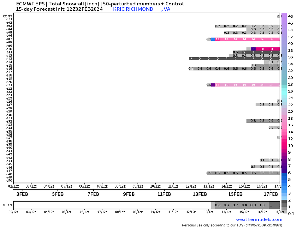
I will take my 1-3 up here in Ladysmith. Richmond once again on the line. This is a tough system to figure out.
-
7 minutes ago, mikeeng92 said:
The euro being suppressed so much gives me hope that this won’t trend too far north for us.
I agree. 00Z Euro run will be interesting tonight to see which way it goes. I think we are fine for now in Central VA with this next system. Not saying it will be all snow, but at least primarily frozen. The only caveat is the lack of a 50/50 low.
-
Yep, I would look at the ensembles. I think either way, Central VA will do good with winter precipitation with the system. I'm up in western Caroline area, which typically does decent with these setups. It all depends on where the low goes which will determine that rain/snow/sleet line.
At least we have something to track for once.
-
1
-


Richmond Metro/Hampton Roads Area Discussion
in Mid Atlantic
Posted
Not a snowflake up here in Caroline. No worries though. It just amazes me how horrendous the models are these days even leading right up to an event. Clipper tracks from the 90s dont happen anymore. They cut right through the heart of south-central VA and gives us all rain. They used to track across NC and give us a nice swath of snow. Just a lot of busts on above climo snowfall predictions but it looked promising at one time.