

BuffaloWeather
-
Posts
25,486 -
Joined
-
Last visited
Content Type
Profiles
Blogs
Forums
American Weather
Media Demo
Store
Gallery
Posts posted by BuffaloWeather
-
-
-
I think Puerto Rico was the hardest hit location of anyone this year in the tropics. Looks like things are absolutely terrible down there right now.
-
2024 totality is dead center across Metro Buffalo but feel like it would be so much better to see at the top of a mountain, but that time of year is tough in the Adirondacks. It's also a really cloudy month as well, so will be interesting to see if it would even be visible.
-
5 minutes ago, Hoosier said:
Finally made it home at an obscene time last night. But you know what, I would do it again.
It was cool to see Goreville, a town of about 1,000, transformed into a bustling place yesterday. I read that there were thousands of people there throughout town, and I believe it. People outside their houses with cameras and telescopes and numerous small and some larger viewing parties.
I was thinking ahead to 2024 and how tempting it would be to get to the exact same spot, if feasible (they get about 4 mins totality). How many people can say they watched 2 total eclipses from the same location?
Top of Mount Marcy in the Adirondacks would be legendary in 2024.
-
11 hours ago, Hoosier said:
After 2024, the next total solar eclipse in this region won't take place until September 14, 2099. There will be several more in the US prior to that though.
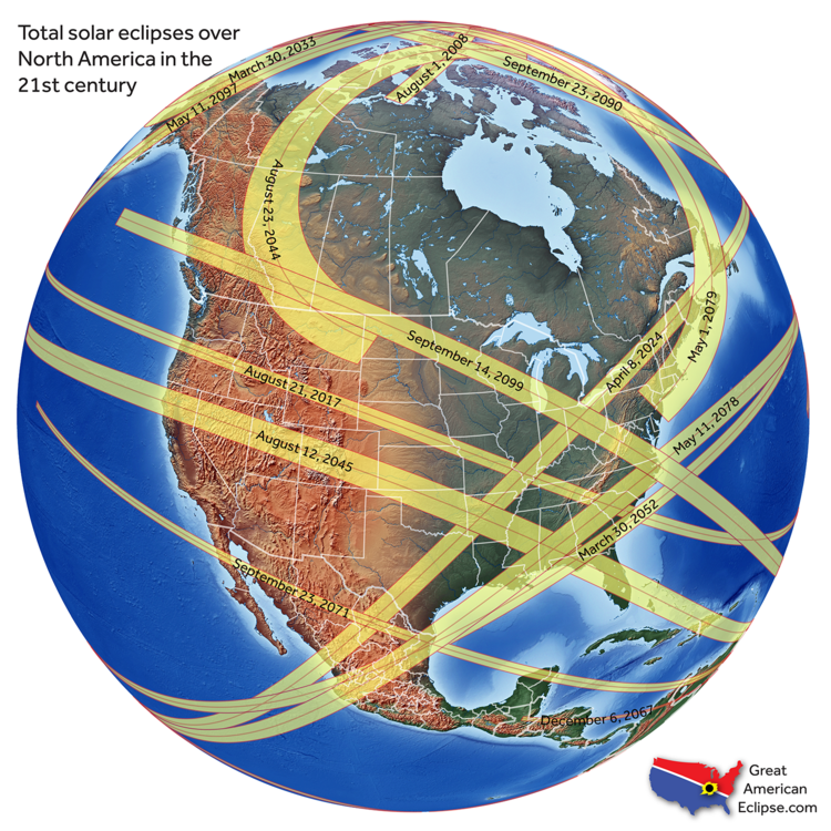
Omg 2024 it goes directly over WNY!!! I was thinking about driving to the one in August, but I can be patient.
-
Are we talking a big time outbreak? or run of the mill type spring central plain stuff? Either way can't wait to finally have some severe action!
-
This reminds of the early season event we had in November 1996... The snow always became more cellular during the day only to organize again at night. Chardon picked up 70 inches... But the snow never seemed to come down heavy until evening. Great event so far so no complaints.
Band looks to be getting stronger as well.

-
A good amount of those snowshowers have come through Chagrin with complete whiteout conditions. Pretty impressive. Hopefully a solid band can get going this evening.
I do think sun angle plays a role with LES this time of the year. Basically the same sun angle as late October. Seems like once evening hits things start coming together again.
It really isn't the sun angle yet. By March the suns angle starts to play a big role. One of the Tugs biggest event ever was Feb 3rd-12th 2007. 143" in 10 days.
-
Radar appearance has become much more cellular... maybe because of peak heating in mid-Feb? Hopefully things can consolidate again tonight. Had a few heavy bursts of snow with the band but it has dissipated.
Lots of shear right now. Later tonight that should relax into tomorrow.
-
That is an awesome band across your area and looks to continue until tomorrow. Wouldn't be surprised at some 2' totals. Congrats guys!
-
I think you guys in northeast Ohio overperform this week. The set-up is great.

-
It's actually 8.8" back in 1918/1919, which is mind blowing. Second place is 21.5" in 1931/1932.
Those records are from downtown, so the stats pre 1940s to post 1940s can't really be compared apples to apples. I want to say the airport's least snowy winter is low 30s, but not sure off the top of my head.
Did Cleveland NWS and Buffalo NWS decide together to move the reporting station from the waterfront to another location? Both of them did it in 1940. Was it just a coincidence?
-
CLE is pretty much the "biggest loser" in the Midwest for snow this year. CLE sits at a pathetic 8.8" on the season, normal is 39", so that's 22.6% of normal. Is there another climate site in the Midwest that's doing worse than 22.6%?
CLE still averages about 29" of snow from here on out to the end of winter. So theoretically if things turned around to normal tomorrow, CLE would end the season at 37.9", still an extremely pathetic winter total.
It's really hard to say what LES will do at CLE, it's often feast or famine. If we get into a cold NW flow for 7-10 days, CLE could pick up an inch or so every few days from passing troughs and clippers, but that wouldn't even make a dent in the deficit. CLE really needs an enhancement set up to make any decent dent in the snowfall deficit.
I'm banking on a late March/early April quick hitting synoptic event for CLE that drops 6" and starts melting right away. Just enough to make the winter less futile, just enough to annoy everyone who thought spring was here, and too late in the season to get any enjoyment out of it.[/quote
Not Midwest but eastern New York is in the single digits for snowfall.
-
No ice, there is always a shot with an open lake of a decent LES event.

-
What an awesome band, enjoy people at the other side of the lake!

-
Really solid band near Cleveland. They just issued a short term forecast alert, but it needs an advisory.
A LAKE EFFECT SNOW BAND FROM DOWNTOWN EASTWARD TO MAYFIELD HEIGHTSWILL CONTINUE THE REMAINDER OF THE MORNING...GREATLY REDUCINGVISIBILITY AND ACCUMULATING AN ADDITIONAL 1 TO 3 INCHES OF SNOWWHERE THE HEAVIEST SNOW SHOWERS PERSIST EAST OF CLEVELAND. USECAUTION WHEN DRIVING.

-
Quincy is on that storm and he said nothing confirmed yet, did have a funnel cloud/rotating wall cloud though.
Edit: Nvm, just confirmed it.
Is Quincy Kelly Williamson on TVN? They are reporting TOG as well, and they are usually really reliable with confirmed TOG.
-
SD proving why it is the best again...


-
I want some videos of this monster fellas. You better take a glory stroll through the heaviest rates.
-
Any threads for predicting snow totals in the big cities. Would be fun to see who wins.
-
Boston is going to get 30+. Living through you guys with this one. Going to be EPIC!
-
At this point, we'd need a Christmas miracle to get snow. Nonetheless it's been interesting to watch the completely different solutions unfold with each run.
Also, 2 things to continue to watch out for:
CLE needs to end the month with less than 2.8" of snow to make the bottom 10 snowiest Decembers. Sadly, this looks completely doable.
And CLE needs to get another 0.93" of liquid equivalent to crack another top 10 wettest year. Rain chances look pretty high on Tues and Weds, but will it be enough? This one will come down to the wire.
This December has been truly abysmal weather wise, endless clouds, no snow, drizzle every couple days, and useless temperatures.
There is some good in this pattern. The lake has no ice and it will probably warm up the next week or so. We will have the entire month of January with an open lake, and that is when we usually get the most arctic air. Last year by January 5th the lake was 70% frozen. The lake is still in the 40s up on the northeastern portion.

-
Yeah euro looks good for you guys with the wrap around snow.
-
Picked up another .2 last night. Looks like an inch or two fell just north of Rt 87.
Trent brings up a good point. If this storm bombs anywhere west of Lake Huron seems like we would be stuck in a SW flow until the storm moves to the NE. 850 temps aren't impressive but the deep cyclonic flow and moisture would do the trick. However, wouldn't the strong winds disrupt the banding? Probably a "green blob" scenario over inland areas.
Temps aren't really cold enough for lake effect behind this storm.

Russian Popups?
in Forum Information & Help
Posted
I've downloaded two adblockers and still get ads. It's brutal, no other website is like this one.