

NVAwx
-
Posts
70 -
Joined
-
Last visited
Content Type
Profiles
Blogs
Forums
American Weather
Media Demo
Store
Gallery
Everything posted by NVAwx
-
Outta gas and Outta Time: Early March Winter Storm finale
NVAwx replied to Ji's topic in Mid Atlantic
IAD dropped below freezing.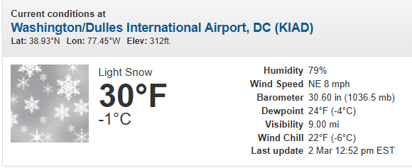
-
Outta gas and Outta Time: Early March Winter Storm finale
NVAwx replied to Ji's topic in Mid Atlantic
Downtown Winchester: Dirt Farm Brewing in Bluemont, Virginia: -
Outta gas and Outta Time: Early March Winter Storm finale
NVAwx replied to Ji's topic in Mid Atlantic
Why'd nobody post? -
Luray at 10 am versus now.
-
Okay. Then stop posting for a couple hours if you can’t handle the model to model changes and nuances in your front yard. Enjoy the full experience and wait it out before jumping ship.
-
Norlurn to west… coastal to east. 🥲
-
The advisory versus warning areas are obviously taking elevation, temperatures, and climo into account. The norlurn trough is also currently progged to be the western warning (Loudoun, Clarke, Frederick MD, the Blue Ridge, etc.). We could have upgrades in the metro area, but for now, that's the best forecast given the melting that will happen. Coastal to the east, elevation to the west. Not unusual.
-
Let's refresh: The "Point" map is the official NWS snowfall forecast in inches during the time period shown on the graphic. This snowfall amount is determined by NWS forecasters to be the most likely outcome based on evaluation of data from computer models, satellite, radar, and other observations. The "Range" map is the 25th percentile (lower number) to 75th percentile (higher number) of possible snowfall amounts based on the Weather Prediction Center (WPC) Super Ensemble output during the time period of the graphic. The official NWS snowfall forecast influences this range of values either up or down depending upon how closely they match.
-
I note the AFD hasn't come out yet.
-
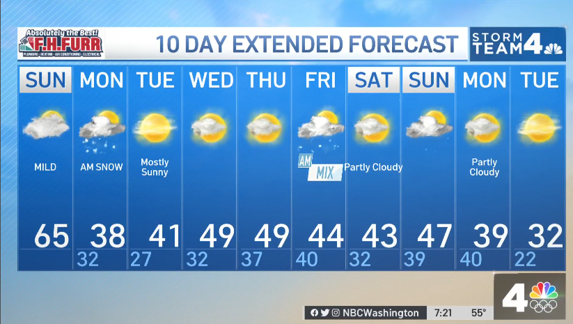
Sunday, January 2, 2022: Monday, January 3, 2022:
-
Maybe you gotta quit saying "ass hair". Synonyms include: Whisker, close shave, by a nose, by the narrowest margin, fraction, marginally, shade, by the skin of ___ teeth, etc.
-
812 AM EST Sat Feb 21 2026 DCZ001-MDZ013-016-504-VAZ053-054-057-501-506-526-527-212115- /O.EXA.KLWX.WS.A.0003.260222T2000Z-260223T1500Z/ District of Columbia-Prince Georges-Charles-Central and Southeast Montgomery-Fairfax-Arlington/Falls Church/Alexandria-King George- Northern Fauquier-Eastern Loudoun-Northwest Prince William- Central and Southeast Prince William/Manassas/Manassas Park- 812 AM EST Sat Feb 21 2026 ...WINTER STORM WATCH IN EFFECT FROM SUNDAY AFTERNOON THROUGH MONDAY MORNING...
-
That's exactly what's going to happen. I thought we were clear from the beginning.
-
Classic. Shadow and energy transfer issues.
-
They can't brine if it starts as rain. It's not sneaking up, you just don't pre-salt the roads in this scenario.
-
Sometimes they do it so it hits the 11:00 news.
-
Perhaps, but in these situations they should be part of the evaluation for the forecast.
-
Even 2" on the Snow Depth Positive Change. Impressive.
-
What about the positive snow depth change outputs?
-
The "Point" map is the official NWS snowfall forecast in inches during the time period shown on the graphic. This snowfall amount is determined by NWS forecasters to be the most likely outcome based on evaluation of data from computer models, satellite, radar, and other observations. The "Range" map is the 25th percentile (lower number) to 75th percentile (higher number) of possible snowfall amounts based on the Weather Prediction Center (WPC) Super Ensemble output during the time period of the graphic. The official NWS snowfall forecast influences this range of values either up or down depending upon how closely they match.
-
I believe the ratio we're using is as follows:
-
Thanks! We've heard from two of their best. Expect the WSSI to update this afternoon. Wonder if they'll do an updated graphic/post at 3:30 pm?
-
Yo chill out though. I know that’s not how we talk in the valley. I asked a question about model performance for a recent storm.
-
AIFS out? That’s a wrap.
-


