

Blizzard Hunter
-
Posts
73 -
Joined
-
Last visited
Content Type
Profiles
Blogs
Forums
American Weather
Media Demo
Store
Gallery
Posts posted by Blizzard Hunter
-
-
2 minutes ago, RU848789 said:
Holy...

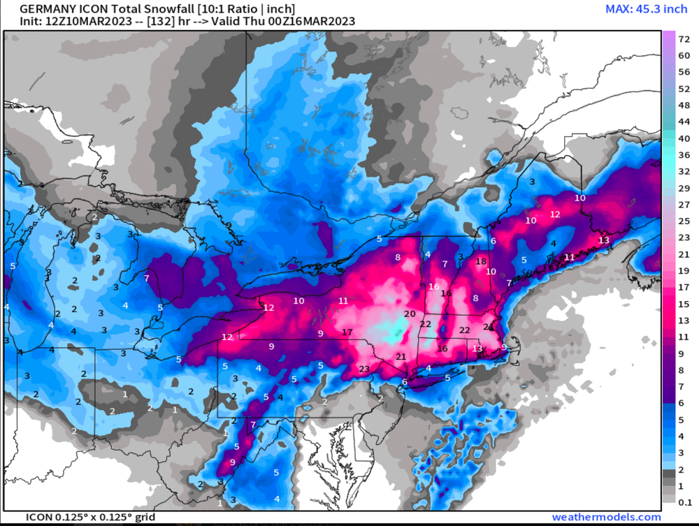
Lol. Trenton gets two feet and Philly gets less than an inch? That would be something.
-
 1
1
-
-
1 hour ago, RedSky said:
Can't wait for my 60hr Ides of March blizzard of wind whipped 30's rain possibly ending in a coating of snow.
This is probably what will happen in our area, but I do think chances are greater than tiny that this thing could trend a little more snowy.
-
38 minutes ago, JTA66 said:
I think us southern folk can safely unbuckle—my legs are falling asleep anyway.
37F
I don't think SE PA is out of woods yet. I get that models favor NNJ and north but if this thing intensifies only a little sooner or moves a little west than SE PA is in the game for accumulation.
-
1 minute ago, Winterweatherlover said:
12z Ukie not on board for nyc snow, gfs kind of on its own right now.
I'm confused, didn't CMC, GFS and NAM all show a western shift with a little earlier NS interaction?
-
1 minute ago, midatlanticweather said:
LOL! Painful ICON
I get that that it is the Icon, but I'll bet final solution is not far off.
-
3 minutes ago, winterwx21 said:
Decent hit to the northwest on the CMC. Mainly rain for the NYC area, with a small snow accumulation at the end.
For a 991 MB storm, surface looked very disorganized.
-
18 minutes ago, RedSky said:
Why am I suppose to be excited about a rainy cutter that is trending into possibly a late developing Miller B that pounds New England, it's never getting far enough south for all of SEPA. At best I get 2-3" of toothpaste up here in the mountains of SEPA. The real potential is a follow up wave but the ECM/CMC don't have any only the GFS.
Give me 50-60F and sunny please
I'm with you here. In a winter where nothing has gone right, I'm supposed to believe they will now when we need even more things to go right for big snow? Bring on spring.
-
1 minute ago, Ralph Wiggum said:
GFS for Tuesday with the deathband. Continues coming South past 6 runs. Actually gets flakes into extreme PA now:

I appreciate the breakdown Ralph, and I am monitoring to see if any big snow storm materializes for SE PA. However, I still think this is headed to a path of snow but not hard enough to stick during the day and any overnight accumulation melted by morning rush hour. I hope to be wrong.
-
 1
1
-
-
10 minutes ago, 87storms said:
Sounds like you're a blizzard hunter. I'm all for a good snowstorm, but mounds of snow lasting through April is a debatable cost.
I am a true Blizzard hunter indeed, and a desperate one. It's been going on five years now.
-
I'b be on bored for something close to a March 1993 superstorm type of deal (Which I know is not going to happen), otherwise bring spring. Given how this winter has gone, it is not surprising that as climatology works less and less in our favor the models are finally showing some good setups.
-
35 minutes ago, clskinsfan said:
Glad to see the Euro finally got a clue that there is going to be a storm out this way. Now all I have to do is start worrying about temps. Whoever gets the deform will get some snow.
Agreed. I think the Deform band is going to be pretty big. Partially wishcasting but also due to the CIPS analogs which was presented earlier. Some heavy hitters in there.
-
1
-
-
33 minutes ago, psuhoffman said:
Problem is where is it pulling the cold from??? there is no cold to tap to our north within 500 miles. The only cold is the pocket of dynamically cooled air.

The slight imperfection that doomed the euro control was the slow movement and early close off of the upper low allowing us to be under easterly flow for too long. Plus by the time the system gets here it’s vertically stacked and not amplifying which is worse for dynamic cooling. Also there is a limit. We’re not asking to cool a marginal column with a wet bulb of 36 degrees. On that run the boundary is torched. It’s too much to overcome no matter how heavy the precip is.Yes, I was wrong to say pull in cold air, I meant generate its own cold air. I am not as well versed in meteorology as others in here, but I have followed snowstorms closely since I was a kid. I do think there are some that are getting caught up on certain things (like mid level and ground temps) and being too dismissive about snow chances. Either way, I appreciate your breakdowns as I try to get better educated.
-
1 minute ago, psuhoffman said:
As I admitted it wasn't an intense a storm as this but it would have been a 4-8" snowstorm if we had anything resembling a normal winter airmass, even a warm one by "normal" winter standards. This would be the most extreme example, but this is also the warmest airmass also, with +15 anomalies heading in and just a small pocket of dynamically cooled mix of modified PC and maritime air behind the incoming trough to work with.
Yes if we get an absolute bomb with a dead perfect h5 pass, and get a meso scale band dropping summer thunderstorm type rates, we could dynamically cool and get snow. That is within the scope of possible outcomes here. But much more likely is that any one of several variables doesn't go absolutely perfectly. The h5 low track isnt perfect. We don't get an intense enough meso band. The low moves too slow and torches the thermals before it gets here. Surface cuts inland too much. There are way way way more fail scenarios than win.
I don't dispute that there are many ways for this to fail, and probably will fail when it comes to snow. I responded to Euro control chart because it showed a 997 low, which obviously means some were hinting at a deeper low than that. There is no way a low deeper than 997 would not be tightening things up and pulling in more cold. I will be curious to see if other models trend toward stronger system.
-
12 minutes ago, psuhoffman said:
Even if I don't say it, its still going to be true. The problem isn't the people pointing out the reality, its the fact its a reality.
But it's happened several times over the last few years. Most recently a couple weeks ago we had an absolutely perfect track storm that was just rain along 95. I think no one noticed because from range it was supposed to be a cutter and it had no hope of snow anyways due to temps so people stopped paying attention but over the last 72 hours it trended east and ended up an absolutely perfect track coastal low but it did no good. We had a couple of those in January and Feb 2021 also. So why are you so sure it can't happen here? I will acknowledge this is the most extreme example of all these recent events I am citing...but its also the warmest status quo airmass also so while I acknowledge there is a chance (please dont interpret this to mean I am saying there is a 0% chance of snow) I definitely do buy the possibility, if not even the likelihood, we get a perfect track driving rainstorm.
You are right that I wasn't really paying attention to the example you provided from two weeks ago. Were temps forecasted to get down into the 30'S for that storm? Was that storm intensifying with a deform band the way this is modeled? I also don't recall models giving any kind of chance for snow within 7 days, till now. My reasoning is mostly that I believe a strong dynamic storm will form and pull away from Delmarva coast ENE, kind of like what Euro shows. However, if strong storm doesn't form and intensify quickly and take good track, then it will be unquestionably rain. A weak storm that takes perfect track will mean rain was well.
-
2 minutes ago, NorthArlington101 said:
not trying to steal @psuhoffman's job here but the surface temps are just scorching and the 850s are only marginally better -- the control throws down this absolute banner of a deform band and it isn't enough to paste the cities, at least verbatim.

I fully recognize getting snow to the coast is going be very difficult in this setup, but with a 997 Low off the coast I do not buy the 0 degree line being all the way in Western PA and Finger lakes region of NY. It is still early February regardless of what kind of airmass we have here.
-
4 minutes ago, Buddy1987 said:
Yoda at least for the 81 crew I’d take my chances with that setup.. baby steps towards a slower less progressive system and dynamics ftw. Here’s to a good 0z run

Agreed. I would bet on more snow in that scenario than modeled.
-
1
-
-
19 minutes ago, Heisy said:
Kind of does a Ukie track. It’s all rain though, not that I’d care about thermals on a Nogaps hah. Where’s Ralph with the CRASS
.Even if that scenario came true, I would expect a changeover to snow.
-
52 minutes ago, ChescoWx said:
The GFS snow for the weekend is only a few hundred miles further south down in North Carolina now....

Yes, but the UKIE, GEFS showed a developing system to the south and if the UKIE was a bit colder, would have been a crush job. They were not doing that before. I think we need to look at this possibility more closely.
* Update - GEPS trended more towards storm idea, not much but a little.
-
8 minutes ago, psuhoffman said:
Why does everything have to be extremes? When someone say's they don't think it will work that does not mean it has no chance at all. There is always a chance. But its about probabilities. We don't forecast based on "maybe if we win the lottery of weather". Look at the preponderance of evidence. The only solutions that show snow each run are the most extreme solutions. The fringe outliers. It's been that way for days with this threat. It was one run of the ICON, then one euro run got kinda close...there was on CMC run a few days ago and more recently the GFS op. Within the ensembles there are like a few members showing snow. The vast majority of evidence says it won't snow. Maybe because the track isn't good (12z GFS/CMC) or maybe the track ends up perfect but its still too warm (UKMET and a few Euro runs). But if you add up all the possible fails (not perfect track, too warm, H5 isn't amplified enough) the probability it doesn't work is way higher than if it does. That's not saying it cant work out...its just making astute observations of the situation.
Of course we want that, its the only way we have any chance at all... but we've seen way too many near perfect track rain solutions over the last few days on this to just ignore that with a "give me that track and it will work out" attitude. It could work out...or it could be too warm. Add in that we might not even get the perfect track and an amplified enough h5 cut off and the odds still greatly favor this not working out. That's all the "debs" are saying imo. Not that it has no chance, and not that it will never snow again.
Ill run the probabilities for anyone interested once all the ensembles come in.
I appreciate your post, but I don't understand why it is directed at me? I was not the one who said there was no chance of anything working out. I was arguing that a Dynamic system changes the rules a bit.
-What triggered my response to the other gentleman was he made it seem like there was no chance. Perhaps I misunderstood, but that is why I responded.
-
1 minute ago, Cobalt said:
12z UKIE
Funny. I would bet strongly more snow would stick than shown here.
-
Just now, Baltimorewx said:
I'm just talking in general...we need good setups and things to work out near perfectly to begin with but this seems like a scenario that is a bit far fetched and the stars need to align. Upper low to closed and bomb enough to create its own cold air layer somewhere.
This idea that it will only snow in a perfect setup is stretching things. It just improves our odds. If a dynamic system forms to our south, then all bets are off. Do I think such a storm will develop? I don't think so. However, if models keep showing one developing, we need to pay attention.
-
3 minutes ago, Baltimorewx said:
Im gonna be a Deb...If anyone thinks this scenario is gonna work out, I got a pair of Tom Bradys crapped stained underwear to sell ya.
I agree that the scenario depicted by the 12Z GFS is not going to happen.
-
1 minute ago, psuhoffman said:
@Ji I’m becoming increasingly optimistic we do get a legit “winter” period in March.
We had a precursor weak SSW even followed now by a more significant one. These scaffolded ones tend to yield results more often. And it’s timing up with the MJO heading towards more favorable phases. I know some will deb it because it’s March but snow is snow and I’ll take it in June if that’s when we get it.
We have had very dynamic snowstorms in March, so I would be on board. In April is when I start to detest any cold.
-
10 minutes ago, Chris78 said:
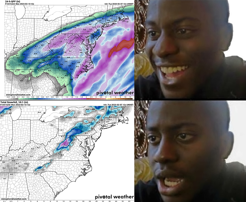
For sure. The iconic Icon tries but it's too south. It does develop a storm which is a win in my book
For sure. I'm still skeptical, mostly due to thinking "nothing else has gone our way this winter so why would this"? However, if such a storm does form as GPS and Icon tries to depict, it would most likely be snow and not go out to sea.


March 13-14th Nor'easter Threat
in New York City Metro
Posted
Correction from what though? Has any model shown the same solution consistently?