
wilsonvoid1
-
Posts
118 -
Joined
-
Last visited
Content Type
Profiles
Blogs
Forums
American Weather
Media Demo
Store
Gallery
Posts posted by wilsonvoid1
-
-
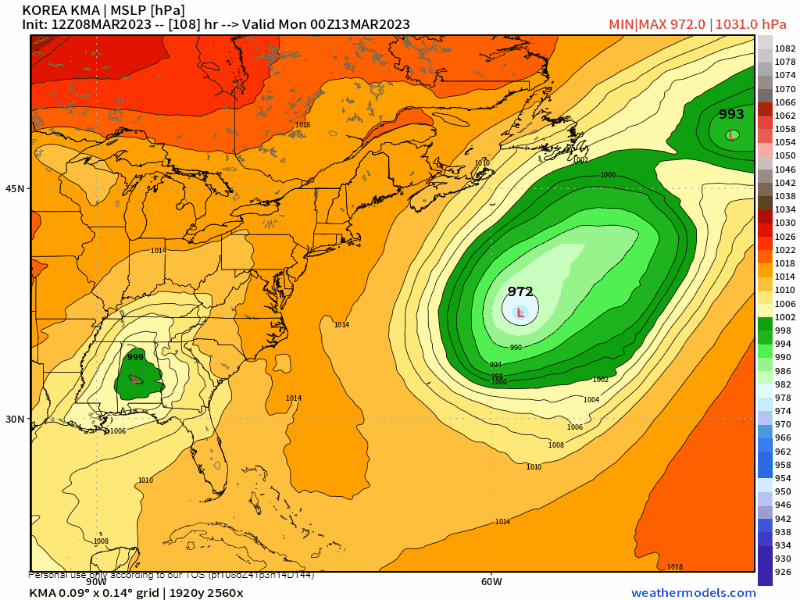
In this case most of us want it to tuck, theres no cold air supply so we are dependent on the storm and the CCB band smashing the area. The more tucked runs seem to actually be snowier. Too far west obviously would be a problem but right now we need a bit of a west shift on the globals.
that actually makes sense, it would be more dynamic and we'd get the CCB at the end of the storm. So you're telling me there's a chance but when was the last time NAM scored a coup? January 2016?
. -
Tony is there a snowmap for this? sorry to bother you
. -
I think the danger is we're three days out and a lot can go wrong. IE the low developing too late or dynamics not being strong enough to cool the BL ect.
But as things stand now verbatim, I think most would do very well. It wouldn't be an epic blizzard for the coast but it would easily be the biggest snowfall of the season.
i agree with yanks fan euro run keeps us in the game
. -

ukmet is the second best model and it does this. Not sure what to believe but trend isn't our friend, if the euro shows this trend more east i am throwing in the towel for this winter.
.-
 2
2
-
-
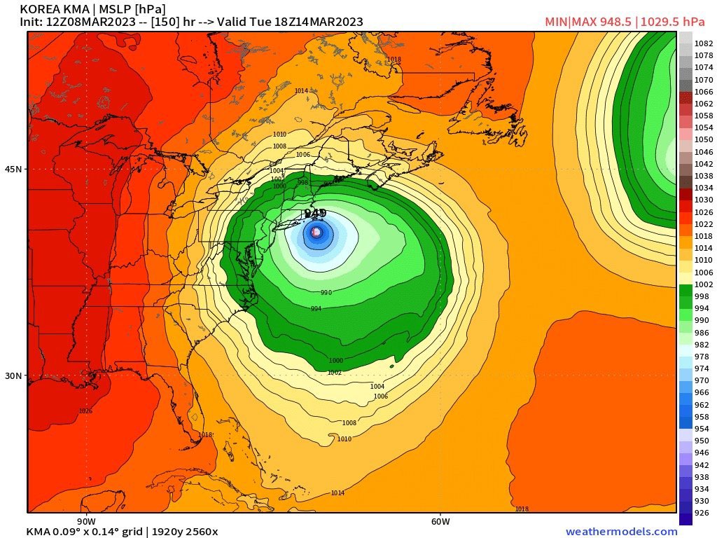
12Z Icon has perfect track FWIW. I dont buy the precip type on pivotal with that track and intensity.

i agree, models always underestimate the dynamic side of cooling. Though it is possible this could end up being all rain for the city, the suburbs will most likely get a lot of snow with that track and intensity. I am not giving up and i'm optimistic with the EPS and euro on our side for at least a few inches.
.-
1
-
-
it can be snowing there while still raining here lol.
back end snow is still better than no snow at all or snow changing to rain
personally with Euros track and intensity a lot of that will be snow even in NYC
. -
Probably somewhat concerning that the GFS is very different.
The GFS was the first to show a late SWFE storm last week while others where much more suppressed.
And technically the 12z models moved east towards the GFS
i don't think that's concerning. Euro schools the GFS anytime
. -
First JV model that can see the storm today (ICON) brings it over E MA....obviously not very good for most of SNE...though ORH county to Berkshires and NW CT do quite well on that run with the jackpot from Catskills to NW MA taconics to buried bodies in S VT.
though I kinda agree with what the germans are depicting, I think that by far that's the worst model, probably worse than NavGem and Japanese model. They should just retire the damn thing!
. -

is there a snowman for that lol
. -
we better get a snowstorm that measures at least 6 inches of snow in Central park for the month of March. I just made a bet with my coworker hopefully I win! If it snows I win the money and I win cause i'm a snow feen let's be honest. Looking forward to the next 2 weeks. It's a small bet but it's all fun and games until we get hit with a blizzard this month
. -
5 inches on the nose at scarsdale nice event could've been more if it was a bit colder the day before

.-
 1
1
-
-
heavy snow 31 degrees about 2-3 inches eye balling. scarsdale
.-
2
-
-
thundersnow showing up on radar to our west. it may hit manhattan again
.-
1
-
-
lull muted, looks like we're ripping the most snow this year starting in minutes and lasting for 4-5 hours enjoy
. -
Hopefully this lull fills in a little. That’ll allow warm air to advance if it doesn’t.
that next wave is a monster 3-6 inches staten island and north cause it's cold now
.-
2
-
-
absolutely ripping out scarsdale
. -
anyone have the euro 18z i want to know what the deal is with the fridays storm
. -
I was just outside in pajamas and t shirt putting stuff away in the shed. Sky is clear. I do not believe this will be anything at all here.
we're going to snow for sure now we have consensus on pretty much all models unless you're south of tom's river you're not getting any snow otherwise 2-4 to nyc, 3-6 nyc 4-8 hudson valley
.-
 1
1
-
-
Oh I started it
oh we're screwed for friday and tomorrows storm is all white rain lol
.-
 1
1
-
-
I didn’t delete anything….if it was then that’s because it was a bad post
i meant to say it did get a little warmer, but yeah let's see what happens it's either way at this point still days away
.-
1
-
-
Hate to say this…but I assembled and started up the snowblower. Had to do it just in case
we got jinxed euro shows warmer friday nite now but i guess the good thing is you didn't start it so start it tuesday morning when there's a decent thump, and maybe we'll get unjinxed for fridays nights event and we get a snowstorm
. -

Hi I noticed you deleted the comment that said EURO was a rainer for friday into saturday crusher storm, but yes it get a little colder it also got stronger and the low technically does go south of us even with todays euro run so not a terrible sign maybe. We do want a nice thump, if anything it could be a snow to ice event more than just snow to rain.
.-
1
-
-
wow euro pretty much held serve for monday night 3-5 and another 8-12 for fri-sat event very nice run hopefully we got this
. -
this winter is getting interesting, appetizer today, dinner monday night and cake friday night?
.-
1
-
3
-


March 13-14th Nor'easter Threat
in New York City Metro
Posted
NAM 6z is a major hit for us way colder and occluded right on time. i don't get it
.