

Benjamn3
-
Posts
73 -
Joined
-
Last visited
Content Type
Profiles
Blogs
Forums
American Weather
Media Demo
Store
Gallery
Posts posted by Benjamn3
-
-
1 hour ago, GaWx said:
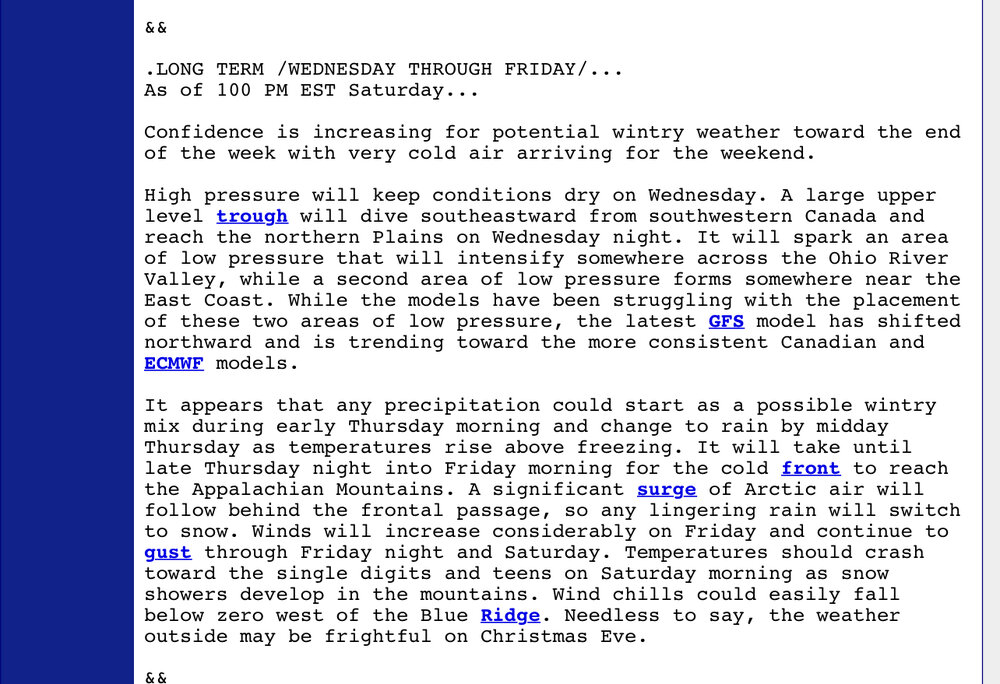
The week 12/25-1/1 is a transition from a bit warmer than normal the week before to the cold 1/1-8. So, changeable, leaning cold last few days of 2023. Similar El Niño favored precip pattern of near to wetter than normal with wettest near SE coast and no dry suggested. With MJO then progged to be in phases 8/1, 12/25-1/1 will have the chance to be a cold week, too, along with a shot at wintry precip.
My main hope is that it isn’t a torch. All I ask for these days is keep Xmas eve and day chilly.
-
 4
4
-
-
10 minutes ago, GaWx said:
The Euro Weeklies have been showing cold in the SE US during the first week of January ever since they reached that far. This cold is being supported well by a progged weak to very weak SPV, progs for a weak to moderate slow moving MJO phase 1 then (typically cold in Jan in SE), prog for a textbook +PNA/Aleutian Low (supported by phase 1 MJO combined with Nino climo), and general winter Nino climo. Today’s is about the coldest yet and is quite notable being that it’s a 101 member end out 6 weeks:

Combine the cold with this…
Precip anomalies tendency for 1/1-8:
Gulf/Miller A potential? This is a signature for that potential. Shoutout to @pcbjramong others regarding this. Just about all of the SE US NN or AN (no dry), which is significant for a cold period since they can easily be dry. This is where El Niño would likely be helping with moist, cold split flow:

How about Christmas/the days leading up to it, looking?
-
6 minutes ago, Weather Will said:
WB latest EURO weekly for Christmas week


Lock it the fudge in.
-
As a member of the VA delegation. I really don’t like we are showing snow a week out. It’ll certainly shift. Lol
-
1
-
-
8 minutes ago, midatlanticweather said:
Go back to 2013 - 2014 for trends that moved south! It was a very odd year and we just seemed to be in the right place balancing cold and the SE Ridge. Rare and unlike anything I had ever seen!
As a resident of western VA this statement saddens me. Lmao
-
3 hours ago, mclean02 said:
Y'all think Roanoke area will see a Inch in this case?
We are modeled to pick up a dusting to an inch. However backend snows are sometimes overdone. I’m hoping we can pick up an inch of powder but I’m not holding my breath for Friday AM.
-
2
-
-
15 minutes ago, Shack said:
So, is no one thinking the ZR potential for Thursday the 22nd has the potential to eventually affect more of the Carolinas CAD- prone areas?
-Decent highs up north
-Traditional underestimation by the models
-etc.
12z GFS shows a decent amount in Southwest VA.
I had similar thoughts. It could be a mess west of the blueridge with snow on the wrap around.
-
 1
1
-
-
I’m in Fincastle VA at the foot of the Alleghenies. Close to about 50 miles the way the crow flies from West VA. It’s looking like we can squeeze in a couple of inches. Hoping for some decent CAD to get us to snow quicker Friday. Whatever falls will stick and stay through Christmas. Trying to be a glass half full guy here. Lol
-
1
-
-
Just now, nj2va said:
GFS brings back an initial burst of snow to start for the 81/west crew.
#ganggang
-
1
-
-
Via NWS Blacksburg VA. At this point I’ll freakin take it. Im right at the foot of the Alleghenies. So hopefully some lingering snow showers will effect me as well.
-
2
-
-
Gotta do what Oprah said. *speak it into existence*.

-
 1
1
-
-
In my oppinion. Which isn’t worth much. We should wait until Monday before we throw in the towel. The ingredients are there, once we can get a better sampling of the data and the models can really get their calculations dialed in we could be back in this thing. Either way, should be a dusting of snow on the ground with cold and mood flakes for Christmas. That’s a win for me man.
-
2
-
-
Just now, yoda said:
Just give me a couple inches. 1-2 is fine. Do i want more? Of course. But a few inches right before Christmas is an automatic win with cold air right behind
My thoughts as well. Have some mood flakes and cold and I would be very thankful.
-
2
-
-
25 minutes ago, BristowWx said:
I’ll never forget Dev 2009. Enough snow for 2 winters…come Xmas day it was warm and rainy…almost wasn’t a white Xmas if memory serves. We are champions snow melters in the MA
You got that right. I live in the hills of VA 30 mins North or Roanoke and even in the mountains we can’t seem to even buy a seasonable Xmas.
-
Just praying the pattern holds for the Xmas season and New Years. So tired of the Christmas torch.
-
2
-


December Mid/Long Range Discussion
in Mid Atlantic
Posted
I really keep my expectations low, so just having cold around for the holidays is good enough for me. In the last almost 20 years it’s a rare feat to get snow in DEC in western VA. So all I want is no Xmas torch. Lol