

ARyan
-
Posts
215 -
Joined
-
Last visited
Content Type
Profiles
Blogs
Forums
American Weather
Media Demo
Store
Gallery
Posts posted by ARyan
-
-
6 minutes ago, NJwx85 said:
The 18z 3k NAM has two lines moving through the area, one around 00z and the next one at 06z. The line moving through CT smacks Suffolk.
The HRRR has another line developing from PA to LI in a couple of hours. It's not as intense but at the same time it might be under doing the current storms.
-
11 minutes ago, Neblizzard said:
Yes the warm front and best dynamics is further north than what the models were showing . Perhaps we can get some scattered convection between 6-9pm. If not the threat is done.
The warm front just enhances the shear locally but the rest of the region is still in play for severe weather. It's just that the tornado threat is much lower.
-
Just now, Juliancolton said:
It was sporting an impressive wall cloud structure a few minutes ago as the cell passed just to my north. There's no fast/good road east so I couldn't get out ahead of it, unfortunately.
Wow. So, is there no tornado with storm or can you not see below the wall cloud?
-
Yikes! Some pretty low CC values with that storm near Amenia.
-
40 minutes ago, wizard021 said:
Mean looking couplet near Hobert NY
Looks like that was occluding and I would expect a new one to form to the NW of that one.Scratch that. Maybe not.
-
The line from Syracuse to Albany is the area to watch. SPC just issued a MCD stating that it's heading into a better environment and will likely become surface-based soon.
-
8 minutes ago, bluewave said:
Today was our lowest humidity on Long Island since the end of June.
This reminds me of severe weather setups in Oklahoma. Sometimes the day before severe weather, the dewpoints can be really low, in the low to mid 50s. At night, the floodgates open up and the moisture starts streaming up from the gulf.
-
 2
2
-
-
4 minutes ago, rclab said:
Frightening, BW. I’ve saved this and intend to pass it on. Is an event of this magnitude possible in our eastern metropolitan coastal areas. It looked like a summary execution by an angry atmosphere. As always .....
We do get derechos but they're not nearly as common as they are in the midwest.

-
1
-
 1
1
-
-
Hearing a lot of thunder in Long Beach. Looks like something might be going up here.
-
...and here comes the wind!
-
Got a good first taste here in Long Beach. Probably 20-30 mph gusts. Now I'm wondering if the flashes are lightning or power flashes...
-
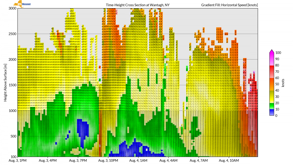
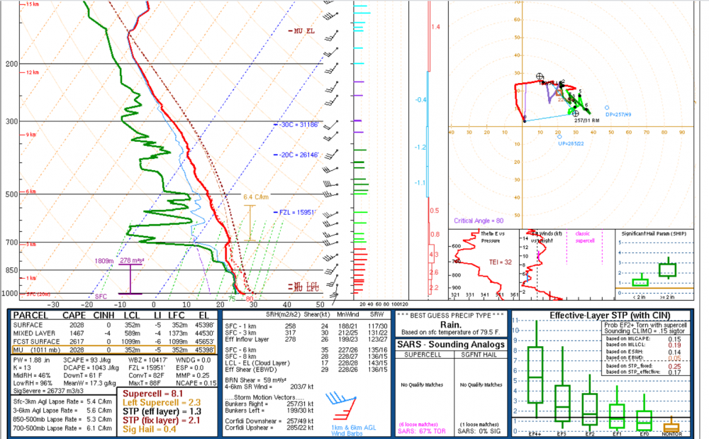
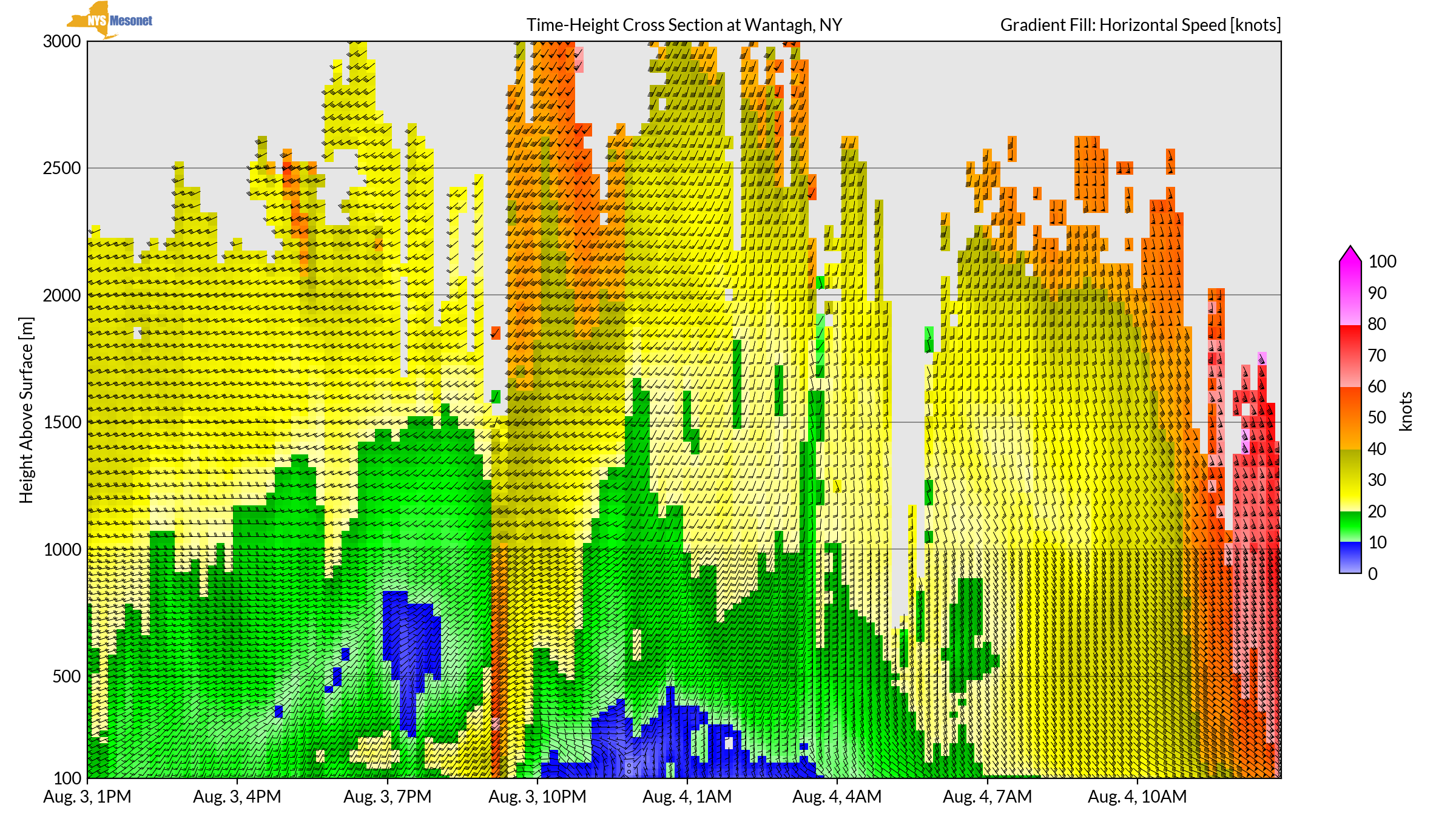
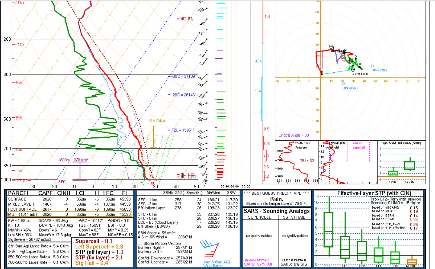
Yikes! This is about as good (bad) as it gets for the region. The lapse rates are still meager and I'd like to see the winds back a little bit in the lower levels, but otherwise...
-
Anybody looking for archived (or current) radar data, check out WeatherScope. It's not radarscope nor GRLevel but it's Free. Also, I attached my script that you can open in the program and be set up for the NYC metro area.
-
11 minutes ago, PB-99 said:
F- 0 IMO
I'd lean towards a microburst but most likely just straight line winds. There's no evidence of a circulation in the water or rain.
-
3
-
-
6 minutes ago, eyewall said:
I doubt anyone will see that except the immediate beaches at most. I would say in the populated areas, maybe gusts to 60 in a couple of spots. The sustained 60 is over open water.
I'm in Long Beach about a block from the ocean. This afternoon should be interesting...
-
1
-
-
Interesting thread. This thread will probably be responsible for me getting my M.S. in meteorology.

Question for NWS/NOAA employees, what route did you take to get your job? I know it's incredibly difficult to get a government job. But what things can you do increase your odds or to make your resume better?

SVR-TOR potential 6P-11P NJ, maybe LI?
in New York City Metro
Posted
Getting quite a bit of lightning and thunder in Long Beach. It looks like the cell over Sandy Hook might graze us.