
Porsche
-
Posts
682 -
Joined
-
Last visited
Content Type
Profiles
Blogs
Forums
American Weather
Media Demo
Store
Gallery
Posts posted by Porsche
-
-
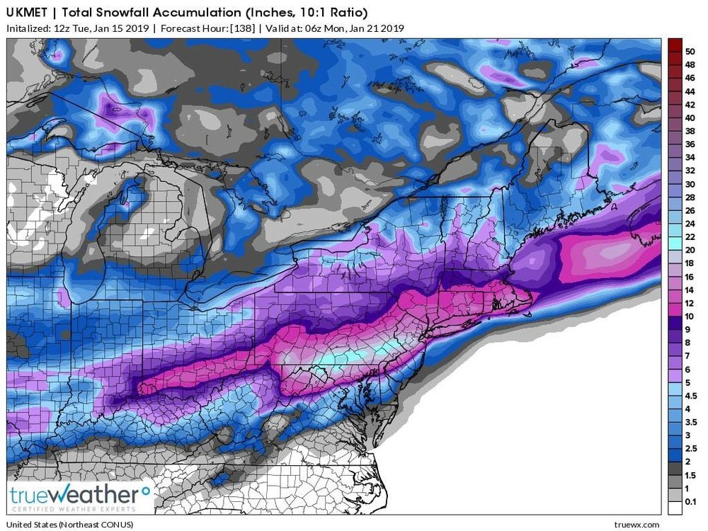
A few mid-morning thoughts on upcoming impacts across the Lancaster area. • A moisture-rich & fast-moving storm--in and out in ~20 hours. • Snow begins ~3pm SAT...may come down heavy w/ sleet for a few hours, then over to an extended period of freezing rain overnight.
6:47 AM - 18 Jan 2019-
New conversation
-
• A brief change back to snow is possible ~8am Sunday, then a quick end as gusty Arctic winds kick up. • Temps will fall throughout Sunday with a rapid refreeze of standing water/slush. • Low temps Sunday night in the single digits with sub-zero wind chills.
-
• Front-end accumulation of snow & sleet will have a very sharp gradient...with <1" in Philly up to 18"+ in northcentral PA. Lancaster will reflect this gradient...perhaps only 1" near the MD boarder up to 4 to 6" along the Turnpike. Perhaps 2 to 4" of snow/sleet in Lanc city...
-
• Ice accretion from the freezing rain Saturday night is the wild card. Surface temps are the critical factor...and this will vary town to town across the county...and so the amount of ice accretion may vary from 0.1" up to ~0.4". Tough to nuance such a complex storm.
-
-
thought you guys might want to hug this
-
 1
1
-
-
ENJOY
")

-
2
-
-
Oh Canada
-
Not bad for right now.
-
5 minutes ago, pasnownut said:
I hate to say it, but I'm just not sure how we get what the NAM HRRR are spitting out IMBY. I see surface maps riddled w/ the wrong colors. Those hi resers are supposed to pick up on that stuff, and I'm gonna call it a win if i can eek out 2-3" before transition. from Ship W and N, yall should have a great event. Carry on. Just trying to keep my local peeps from lookin for ledges.
Agreed, I went for a coating to 2" so I don't think I'll be dissapointed today. Just sitting back enjoying this a week before Thanksgiving!
-
at 09:43) Temp: 29 F | Dew Point: 20 | Wind: NE - 4 mph
Sleeting now.


Central PA - Winter 2018-19
in Upstate New York/Pennsylvania
Posted
Kuchera