

eurojosh
-
Posts
2,350 -
Joined
-
Last visited
Content Type
Profiles
Blogs
Forums
American Weather
Media Demo
Store
Gallery
Posts posted by eurojosh
-
-
Totally self-interested question: I'm booked the last week of Jan at Timberline, based on that having been a great window the last couple of years (including one morning last year when it was -30 before dawn!!!). Am thinking I might push it back to the first week of Feb, or cancel all together at this rate. Don't have to make a final call until a week out (so, 10 days from now), but welcome folks thoughts!
-
Ah yes the annual "will it stick if it was 60 yesterday" debate, a hallmark of this board.
-
Never ceases to amaze me that climate change remains a topic of debate on this board. Like, I realize that drawing a line to the precise effects is difficult, if not impossible, and that our local Wx, including annual snowfall, is not representative or necessarily indicative of any specific climate-change-induced global pattern, but when folks pop up to say it has no measurable effect on our Wx whatsoever (in the winter precip context) I'm always somewhat flabbergasted.
-
Not to belabor the statistics, but I'd be curious to see an analysis of how much snow in each season was a result of 'big' storms (either as a function of amount - say 6"+ or as a function of percent - say, 33% of seasonal snowfall) as opposed to spread out over multiple smaller events; my sense is that climate change reduces our overall odds of frozen precip and bunches what does fall into increasingly atypical large events - but I've no idea if the data would bear that out or not.
-
 1
1
-
-
41 minutes ago, frd said:
Unless I am very tired, it appears the GFS may eventually trend to it.
Also, HM said he feels there is room for things to come together next week. Thats good enough for me at the present time.
From HM > " This timeline makes more sense, on a larger scale sense, than the 12/23 threat since that comes with the Siberian express. Not impossible to get favorable trends with this next week. " >
It'd certainly be more in line with our climo to get winter precip on the back end of a departing HP than on the front end of it - and we sweat the ptype as the warmup follows.
-
1
-
-
18Z GFS looks the same through hr6.

-
 12
12
-
-
...And a (mostly) rain storm for BOS?

Not fully buying this solution yet.
-
I've been off this forum for a couple of years but 1 observation and 1 Q
Observation - re MLK weekend, I think GFS is doing that thing where it sniffs out a storm in the LR, loses it, and eventually claws it back a week or so out. We'll see.
Question - what happened to Ji?
-
7 minutes ago, RevWarReenactor said:
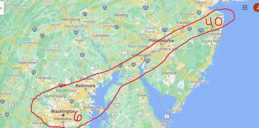
I could go on forever addressing this post and the other, but It would be banter. I don't get jealous of North NJ snowfall because I understand its a different climate up there,The area outlined should be a jealously zone because generally speaking they get the same amount give or take 5 inches. But lately, it is extremely lopsided, its like a different climate up there this year. This year the northeast end of that is at 40 inches, the southern end is at, a few?
Is it bad luck? Or is something happening down here?
more fail line than fall line amiright
-
 1
1
-
-
All the models I've seen today make this a close play for our section of I95. Absolutely on the margins. Shift east 30 miles and we bullseye, shift west by the same amount and we'll be lucky to get a couple of sloppy inches. My gut says that's bad news at gametime - I think maybe 1 in 5 like this break our way?
-
A fair amount of wishcasting going on in the December thread on how to make the GFS and Euro look like the GEM....
-
2 minutes ago, WxUSAF said:
Yeah it’s had it for 2 runs. Gfs for a few now also.
Icon well positioned for the same just after the run ends. Would be surprised to still see this as a possibility after a couple more runs, though - I don't think our climo is as favorable as it was in 1987...!
-
How is it possible no one is posting about the 18z gfs?
-
On 2/16/2019 at 10:24 AM, eurojosh said:
I'm counting on this storm. Thinking about taking Tues-Thurs off and heading either to Blue Knob (CAD) or Timberline (Coastal) or not and going to fing work (cutter).
Pulling the trigger on Blue Knob. Wednesday's gonna be beast.
-
I'm counting on this storm. Thinking about taking Tues-Thurs off and heading either to Blue Knob (CAD) or Timberline (Coastal) or not and going to fing work (cutter).
-
1
-
-
1 minute ago, jewell2188 said:
DT is literally trolling on Twitter....bashing every met that mentions Tuesday
Maybe but it's hard to find those Tweets among his various insights on Constitutional law.
-
1
-
2
-
-
Someone should go back and calculate the seasonal average ratios of posts to inches. I bet this one would rank pretty high.
-
1
-
-
Is the old chestnut that the Euro handles southern stream better, the GFS northern, still thought to be (or ever thought to be) true?
-
2 minutes ago, Deer Whisperer said:
only took one time to realize you shouldn't say anything about a run til its finished. learned my lesson lol
Don't beat yourself up. There is actually some predictive value to the early frames, but I find it's more useful to avoid the precip panels and start high. Take a look, for instance, at the steering flow itself, the 250mb pattern. Compare 36 on the NAM and 42 on the 18z GFS. On the NAM you can see there's a piece of energy over Chicago (etc); on the GFS, it's not there. It's always a guessing game, but what that piece of energy ends up doing is forcing the NAM south; without it there, the GFS flow is more flat, allowing the energy in the west to ride straight across country, and further north by the time it reaches the Atlantic.
-
1
-
-
2 minutes ago, Ralph Wiggum said:
Please keep me posted I'm on the edge of my seat
Killer showers in Charleston.
-
1
-
-
12 minutes ago, MD Snow said:
Icon with a 1002 mb lpc at the SC/NC coast/border at hr 120. Temps look iffy but it’s got the coastal idea for weekend deal.
The ICON's single most valuable addition to the suite is to give the particularly impatient something to look at in between the mesos and the GFS.
-
4
-
1
-
-
3 minutes ago, BristowWx said:
No..no we can’t
All in.
-
1 minute ago, Ji said:
What a fv3 weenie run
Meh. Move the LP in the first of those KUs 50 miles south and I'd agree with you.
-
The nice thing is that after Friday we can go back to focusing on the storm after the storm after the storm.
January 2023 Banter
in Mid Atlantic
Posted
Welp. Gonna take my chances and hope it's not a total washout.