

Weathertree2
-
Posts
52 -
Joined
-
Last visited
Content Type
Profiles
Blogs
Forums
American Weather
Media Demo
Store
Gallery
Posts posted by Weathertree2
-
-
No one please take this post the wrong way but I though there was a specific observation string or thread; I like reading the observations but when they are intermingled with posts regarding long range pattern stuff it just gets messy.
-
 1
1
-
-
Just now, Carvers Gap said:
We want tracks south of us. Yes. The coastal blizzard modeled for next weekend would likely rake eastern portions of the forum area just verbatim to that run. That said, that look will certainly change. Getting systems below us, and northern stream energy syncing on some model runs is about all we can ask for at this range.
True enough it will change thanks!
-
4 minutes ago, Carvers Gap said:
This is a pretty nice 12z GFS run. What the others were not...this one is.
What am I missing these seem to be modeled south of us. Are we expecting the NW jog?
-
1 minute ago, Carvers Gap said:
Also, at 204 the 12z GFS also has a fairly potent winter storm.
That is really really far to the South; I would have expected to see some extreme cold here with it that far South but it is not really
-
1
-
-
1 hour ago, John1122 said:
The 06z GFS is back to a Miller A look that somehow cools enough on the Plateau and NE TN to snow, but rains to the Ohio River.
And warms enough to rain at end of run, which two runs earlier, depicted a historic ice storm for west TN
-
Been a long time since seen such a good winter pattern, hope everyone gets their snow fix this season!
-
8
-
-
This is one mess of a system, been rainy here overnight and all morning sitting at 32 blah go away
-
5
-
-
5 minutes ago, WinterWonderland said:
So we're not getting the "finger" as bad as we were?
")
Perhaps depends what model you choose.

-
4
-
 3
3
-
-
-
6 minutes ago, fountainguy97 said:
GFS packs on an additional 24hrs of NW flow. Stacks up additional 6" across mountains. Thanks to the kicker energy
The whole system seems disjointed
-
 1
1
-
-
5 minutes ago, Dsty2001 said:
Yeah i'm not throwing in the towel just yet. Seen too many times models readjust 12-24hrs prior and with a system like this, minor adjustments can lead to some interesting changes.
I know if Middle TN gets it again, we will be well on the way to one of the snowiest seasons of the last several years, really reminds me of the winters of my childhood - 1970's
-
3 minutes ago, Vol4Life said:
It’s really depressing to see virtually the whole state modeled for a major winter storm except the valley where it’s basically showing a heavy frost. This is more for the banter thread, but I’m hoping airing our grievances will change our luck like it did for Nashville. I remember those posters several years ago moaning all the time about the snow hole there. Now, their weather is resembling Snowshoe, WV...lol! The snow curse needs to be lifted for the Valley!
I feel for you; I can say I have allot less experience than most on here but it just seems like this one vs the last one has a higher bust potential.
-
12 minutes ago, John1122 said:
Parts of their CWA got 10 inches last storm.
I got 8"
-
1
-
-
Just now, MattPetrulli said:
No longer a Sevier County exclusive snowhole, I would accept 4-6 inches.

Um that doesnt look like the forecast that Nashville is referencing, must be more of the "stuff" on the internet
-
2
-
-
000
FXUS64 KOHX 132118
AFDOHX

Area Forecast Discussion
National Weather Service Nashville TN
318 PM CST Thu Jan 13 2022

.DISCUSSION...

UGH! What a hard and challenging forecast.

The upper impulse will continue to move through the area for the
next couple of hours and skies should clear out a bit overnight.
Tomorrow /Friday/ will be dry. Now here comes the challenges! The
models are still all over the place with no consistency to each
other or even to themselves. The NAM low had been moving north to
come in line better with the GFS and EURO but not the 12/18Z runs.
Was hoping there would be some kind of meeting in the middle for
the models...but no luck as of right now. The previous forecast
had the heaviest snow over NW Tennessee and along the TN/KY state
line. Current forecast now has the heaviest snow over the Plateau.
Let/s go with there will be a band of heavier snow somewhere
around I-40 and north. Where...your guess is as good as mine. The
higher amounts look to be in the 4-6" range...not some of the
crazier high end extreme amounts floating around the internet
right now.

Friday night into Saturday expect a really cold rain maybe with a
few flurries mixed in. It will take some time for the boundary
layer to cool down and moisten up. If any snow falls no
accumulations expected. With highs on Saturday in the 40s it will
be raining until possible late afternoon where there could be a
rain/snow mix first starting in the Fentress/Picket county areas
then spreading down the Plateau and west across the KY/TN state
line. That rain snow mix continues southward overnight and changes
to all snow for I-40 northward and the Plateau. The system pulls
out Sunday night and morning lows on Monday will be in the upper
teens to lower 20s. Would expect there will be some travel issues
Sunday night and maybe into Monday.

Highs on Monday in the 30s...so there could be some residual
wintery stuff around. Lows Monday night into Tuesday continued
cold in the 20s...but highs on Tuesday in the 40s so everything
should melt.

There is another short wave Wednesday and Wednesday night. Chance
PoP no really QPF expected at this time.

&&

.AVIATION...
18Z TAF DISCUSSION.

Mid clouds and a few sprinkles will move across terminals this
afternoon, but conditions should remain VFR at all sites. CSV
could see some fog development early Friday morning thanks to the
additional moisture pumped in by this afternoon`s wave.
Visibilities may fall for a few hours around sunrise. Winds will
be out of the northwest around 5 to 10 knots today, then become
lighter and more northerly overnight tonight.
-
2
-
-
7 minutes ago, Carvers Gap said:
18z NAM is north of its 12z run and the warm nose is howling. On to the next run. Always tough to know if the NAM is onto something or just amped. Would have like to have seen some consistency there. Looks a lot like the amped GFS runs.
I am liking that run for sure looks good for my area
-
1
-
-
2 minutes ago, Olhausen said:
It makes it easier that a lot of middle Tennessee folks just got a huge snow. That said it would be a vary rare event if the area gets another 6+ inch snow event in the same year let alone the same month. I really really want this one to pan out just due to the historical nature of it. If it does work out and with the pattern coming up middle Tennessee would be on the way to one of the snowiest winters it’s had in a long time. It does seem the Nashville snow hole is taking a beating over the last 7 years or so. Since 2015 White House has had 5 winters out of 7 that have had at least one 3 plus inch snowstorm.
Yes, would be nice to see this one pan out for sure
-
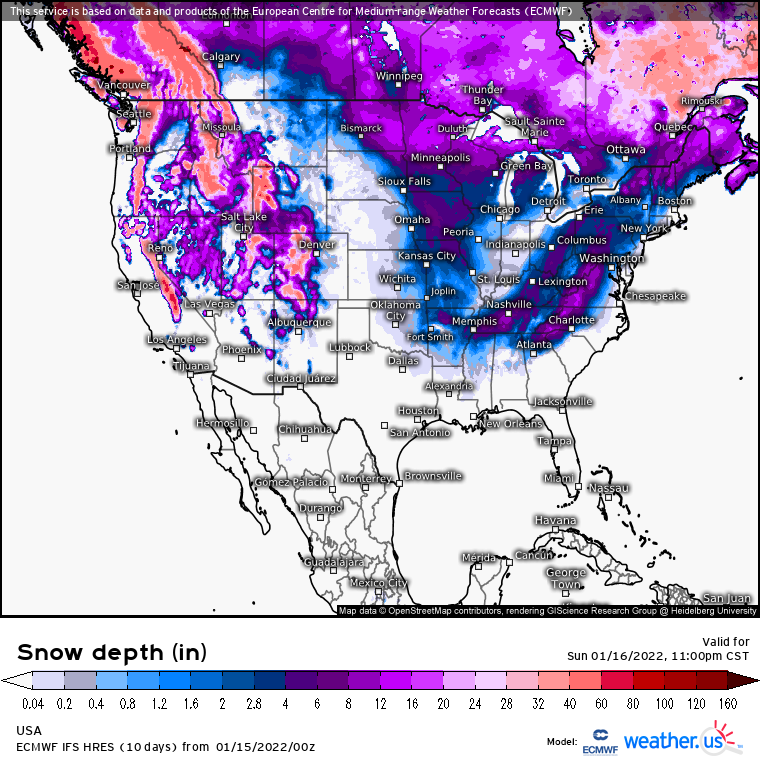
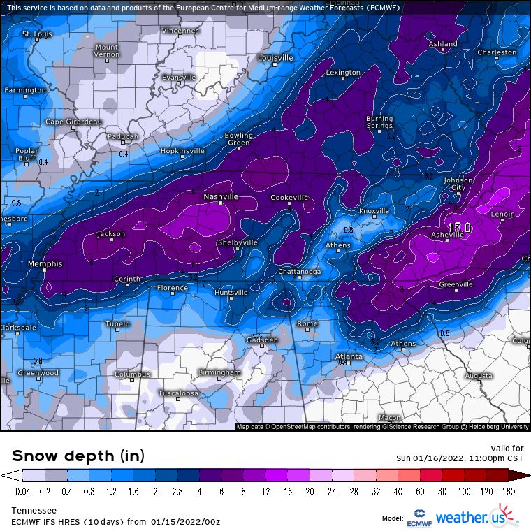
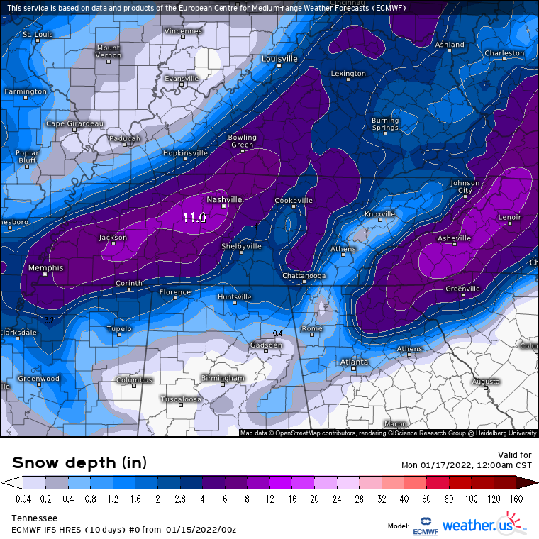
6 minutes ago, Holston_River_Rambler said:
Snow map:

Wow that seems like a big shift
-
2
-
-
Really not liking the icing that the GFS is depicting north of Nashville before the snow
-
1
-
-
2 minutes ago, Vol4Life said:
Do you know what the official measurement from BNA was for the last storm?
We would be in rare territory if that occurred for sure
-
2 minutes ago, Vol4Life said:
Do you know what the official measurement from BNA was for the last storm?
6.3"
-
2
-
-
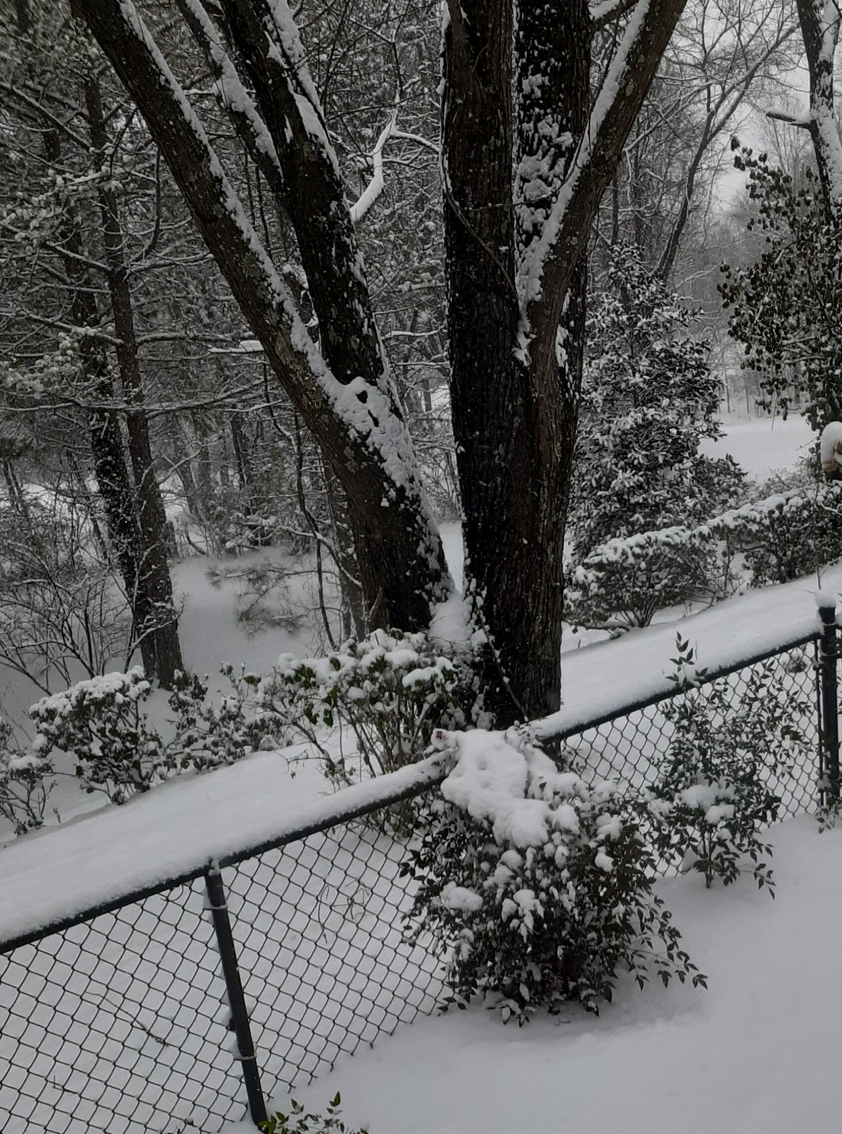
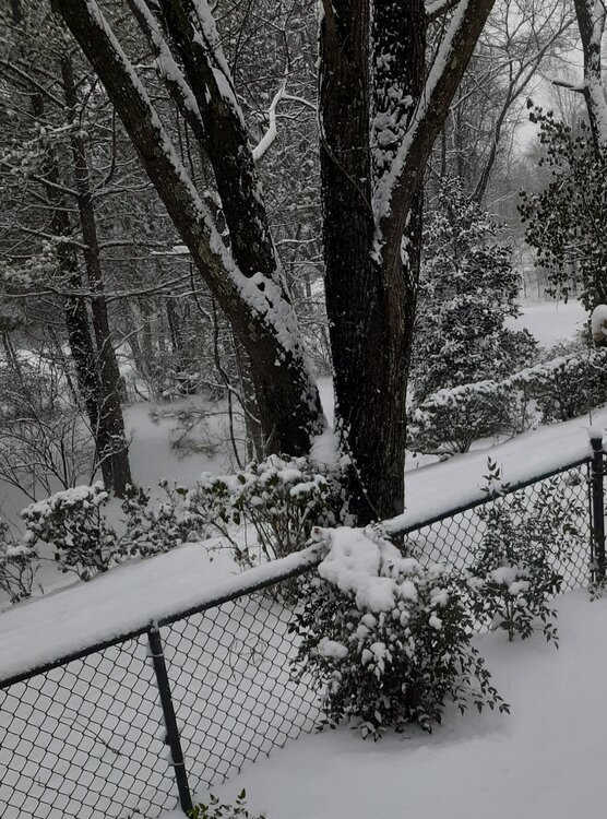 Some pix from last system, ended up with about 8" imby
-
3
-
-
53 minutes ago, John1122 said:
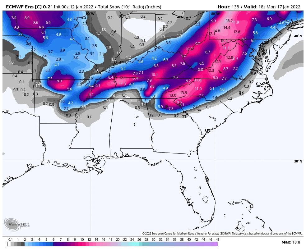
The Euro control keeps firing bullets.. There's a 30 to 50 percent probability of greater than 6 inches of snow across a lot of areas in the state on the EPS probability map.
Fair to say that someone is going to get plastered. Maybe by this time tomorrow models will have better handle
-
1
-
-
9 minutes ago, Carvers Gap said:
That is a non-starter for our area. Handoff leaves thermals washed out. On to the next run.
Got missed on that run also


Winter 2021/2022 January Thread
in Tennessee Valley
Posted
That is an insane amount of snow lol