

jwilson
-
Posts
1,146 -
Joined
-
Last visited
Content Type
Profiles
Blogs
Forums
American Weather
Media Demo
Store
Gallery
Posts posted by jwilson
-
-
To be honest, I almost want to look beyond this event and notice both the Euro and GFS setting up a rather significant -NAO block the following weekend.
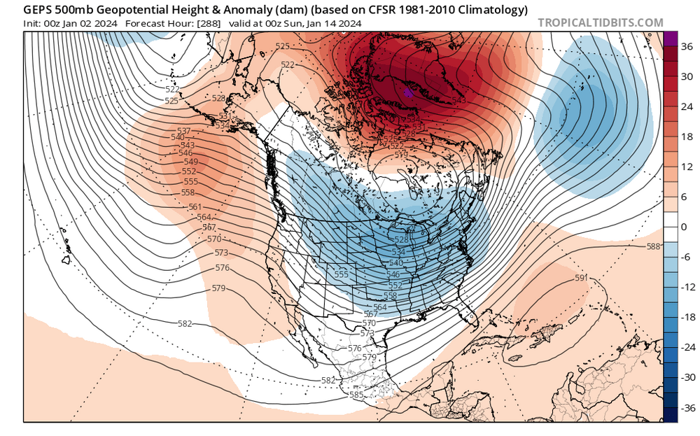
The ensembles and operationals all have it. Traditionally, when you would weaken a block of this magnitude is when you hunt for the KU, but it's presence looks likely to deliver us the first chance of real cold this winter. Anything that happens underneath is worth watching. It's been a while since we've had this setup.
-
 1
1
-
-
Half of the 30 GEFS members show a 6"+ storm for Pittsburgh metro or are very close to it. Perhaps 10 certain and then a few that are inexact given the resolution. That's not quite what I'd consider "honking," but it's still quite good at this range. A handful more show a fringe event (borderline minor to moderate or a fringe special). Five show what's basically a non-event.
-
There's a signal for something this weekend, which is about the best we've done in quite a while. Plus with the weekend rule in effect, that's an additional +25% to confidence scores.
I do prefer this one south to start - at longer leads, that is. We know that they generally bump north gradually as the T-0 clock closes. If the starting point is us getting bullseye'd, mixed, or some kind of southern fringe solution, chances are much higher we'd lose it altogether. If we're still on the northern fringe at say 48 hours, then you start to get worried about suppression.
-
2
-
-
3 hours ago, TheClimateChanger said:
When I look at years with ONIs equal to or higher than this, I see a lot of disasters in Pittsburgh. Do you guys think this winter will be the second straight disaster?
Here are all cases of a wintertime ONI greater than or equal to 1.8:
1957-58: 37.0"
1965-66: 48.0"
1972-73: 26.3"
1982-83: 30.1"
1997-98: 24.2"
2015-16: 29.6"
Mean: 32.5"
Five of six cases were below the normal seasonal snowfall. The most recent 4 of which were around 30" or less for the season.
It is getting more difficult to extrapolate based on past data, although last year (considering previous 3-season Ninas) I didn't expect much and that turned out prescient. We hit our lowest snowfall total since the winter of 1990-91.
This year I'm torn. Super Ninos can definitely be too much of a good thing, as you've already pointed out. We also don't get the same ocean influences as the coast, so while they may require certain conditions, what's good for them may wreak havoc on our own snow chances.
The odds of beating last year are quite high, however. Almost automatic. We haven't had back-to-back sub 20" snowfall winters since the early 30s. Doesn't mean we'll be above average, of course. Maybe that also means we're due.
I will say, almost every time we've hit +2.0 on the Nino scale, we've had <30" that winter ('82-83 was 30.1" so close enough). Not sure if we'll get to that deviation but it does look close. If so, your safe bet might be on a sub 30" winter.
-
Thunder and lightning here. Now it feels like Christmas!
-
Little hope for Flyers or Sixers, so it's all up to the Eagles now.
I do think the Phillies could have won that series were it not for a mismanaged Game 4, although two years in a row of dead bats is concerning.
-
To be honest, I don't expect any real snow until January or February. Maybe we get lucky with some small stuff, but through December figures to be warmer than average. Typical El Nino stuff.
-
1 hour ago, KPITSnow said:
Looks like we lucked out today
A little disappointed we couldn't eke out a basic thunderstorm. We haven't had that many this year (at least in the South Hills).
-
2
-
-
35 minutes ago, TheClimateChanger said:
So far, we have been fairly lucky, although snowfall has trended downwards over the past several decades. Since 1950, I calculate the trend as a loss of 7" per century, so a fairly slow decline. But looking at the map posted by Brian Brettschneider, it looks like the oranges and reds aren't looming too far to our south. Do you guys think we will eventually reach a level of warming where snowfall in Pittsburgh plummets on the order of 25 or 50 percent?
I think that's probably likely as our climate moves towards a facsimile of Atlanta. Pittsburgh is a bit too far from the lakes to get the "real" influence and too far from the coast to benefit from all the coastal bombs that are forming nowadays with warming waters. Hence why the coastal sections all run in the positive deviations. It's also not at a high enough elevation to generate the kinds of mountain snows we'd see in the ranges. We tend to nickel-and-dime our way to 40" as it is, and I would imagine tiny shifts in climate can make some of those little events become less common or more likely to be rain showers.
-
The long-term pattern still not showing much sign of abating. The west dries up, and while we aren't quite as dramatically under a trough the whole time, we're still wet-looking for almost the entire period. Really everywhere from the plains on east.
2-3" over the next week.
-
The trough-in-the-East pattern still holds in the long-term. It doesn't look supremely wet, though, so it's kind of a mixed bag (only 2" of rain through the end of the month).
The only real ridging in the conus is pretty narrowly focused over the central plains. This pattern will limit the heat potential, which I guess most people prefer. How much rain we end with is the question and if things change come July.
-
1
-
-
22 hours ago, Ahoff said:
I'm exaggerating a bit. I don't think it will be 60 everyday, but frequent 60s and rain into the end of the month would really put a damper on the start of summer.
Looks like that's the pattern for the foreseeable future. Hudson Bay highs with everything rotating underneath and cutoff. Probably 3-4 weeks at least. I'm guessing by the end we'll have made up for most (if not all) of the deficit.
-
Next week looks like a repeat of this week with the low further south. Kind of a depressing pattern if that holds up. Figured we'd pay for that nice stretch of weather at some point.
-
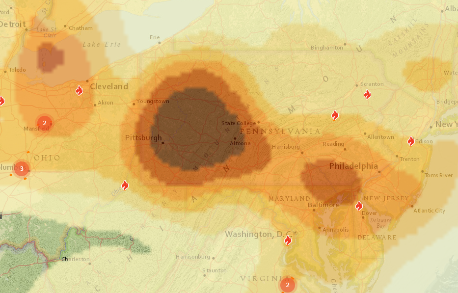
Friday could be another bad smoke day. Courtesy FireSmoke.ca - this is Friday morning say between 8 AM and Noon. We'll see if it holds.
-
5 hours ago, TimB said:
Our first GFS clown range triple digits of the season appeared this morning.
When is the last time PIT hit 100F? I think the last time I can remember temps that high out here was like 2012 or 2013. I lived in Morgantown back then and we did manage to go over 100F.
But I think that's it. Seems pretty rare for PIT to go up there. I feel like we haven't even had that many serious heat waves over the last decade. Perhaps I'm used to worse summers coming from Philly.
-
On 4/22/2023 at 8:40 PM, Ahoff said:
Looking pretty cool for at least the next week. Not great.
GFS looks bad for the first week of May. 30s and 40s (as highs). We'll see if it holds, but that's not a terribly great start to pre-summer. I knew we'd pay for those early 80s, though. Snow flurries the last two days.
-
3 hours ago, TimB said:
I’ll never understand looking forward to the stifling heat and humidity that awaits us in about 7 weeks, probably with tastes of it before then, and will likely last 4-5 months. If winter ever had as good a hold on us as summer does every single year, no one would ever have any lack of snow to complain about.
For me it's just over this particular season. The winter was dull; we only got to track maybe two total events. Most were 10-day storms that disappeared after a couple model runs. There wasn't much to get excited about.
Now I'd rather get some good golfing weather for the spring before the heat really sets in, rather than a continuation of fake winter. It's nuisance cold, for the most part. I'd prefer some temps between cold and hot, say 60s and low 70s with minimal humidity.
Spring and Fall used to be good for that, haha.
-
1
-
-
Sadly looks like we're mired in fake winter for a little while longer where we keep getting shots of cold air. Perhaps a good year to bet on some April snow. Crap.
-
Outside for a while today and it felt like summer towards the end. Winter can die now, peacefully I hope, but we'll probably get something now that many have lost interest.
Still don't buy long-range cold threats. No reason to based on the winter we've had.
-
1
-
-
I give it less than 48 hours before it shows a cutter.
-
1
-
 1
1
-
-
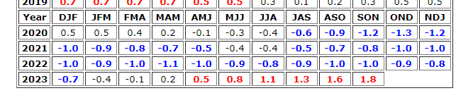
7 hours ago, TheClimateChanger said:
This is the cumulative departure for the last 4 winters (2019-20, 2020-21, 2021-22, and 2022-23 to date).
Instinctively I want to say these years are sort of typical in terms of longer-term La Nina alignments. It's something I should probably research if no one else beats me to it.
Granted, past analogs may be losing their value and there's so many variables to account for each winter. I'd still be curious about the extent of the similarities.
-
1 hour ago, RitualOfTheTrout said:
It can't be 100% attributed to any one storm or season. Climate change will make bad patterns even worse, ie to your data points maybe 100 years ago a bad winter pattern would yield 5 inches of snow on the season and 2 70 degree days, but now its 2 inches of snow and 6 70 degree days. This pattern would suck in any era relative to normal. Does climate change play a role in making these "bad" patterns more frequent or make the "good" ones less effective? Does it make past analogues with a marginal setup where we just squeaked by at 32 and had heavy snow now more likely to be an all out fail? Does it further reduce other forces that might mitigate a bad situation to make it workable for snow? Probably, but its going to take decades to see that trend in the data.
It's even likely that we see some sort of "sweet spot" were warmer more moisture laden atmosphere meets up with still cold enough planet to increase our snow averages. Maybe we are in that now, or getting to the tail end when its more likely going to be to warm, no way to know yet.
Admittedly I'm basing that on the idea that the change will be slow, at least relative to the scale of a human lifetime. Maybe that's wrong and once we get past a certain point exponentiation deterioration will rapidly put an end to winter weather in our area. Point is I'd need to see several years to say this season is anything close to a "new normal".
I think this is one reason people still lean into denial that any sort of global-scale climate change is occurring. It's not always obvious on an individual basis, and this is how we humans tend to perceive things. To say the world is gradually heating up is a bit too "abstract" in the sense that, on a day-to-day level, we don't really notice it. The other issue is we can't over-attribute singular events (or seasons) to climate change with our limited scale of knowledge. There's the causality versus correlation dynamic, and we don't have a firm understanding of it yet. We'll probably all be dead before we get the chance to figure out if 2022-23 was a bum winter because of climate change, or more likely that's something we'll never know with any kind of certainty.
(And mini-rant here, but I'm not terribly concerned with offending peoples' "sensibilities" on a topic such as this on a weather board; it has been artificially politicized.)
-
2
-
-
Typical big game that's lost on the finest of margins. The Chiefs' biggest (and pretty much only) mistake the entire game was a missed field goal.
Eagles gave KC 7 free points. Then allowed a big punt return. Made a number of poorly timed penalties (not the first such incidents this season). Yeah, the defense was miserable, but the Chiefs' defense wasn't exactly managing the game, either. Time of possession was never going to matter with Mahomes on the other side. The Eagles had to play a perfect game and they didn't. It was basically the same story in SB LII but the defense made a timely stop in that game to get the win. The defense made zero plays last night.
On the bright side, Hurts is a real dude. The mistake was as costly as it gets, but he played so well otherwise. The question is whether the Eagles can turn this defense around over the next few years to make more playoff runs and then long-term OL health. I'm not really anticipating they'll be able to make it back next season, and that's one reason this loss is so egregious. But maybe Howie can work some more magic? Draft is crucial. They need cost-controlled assets that can actually contribute.
-
1
-
-
Bring on the warm weather. Feels so nice today. This winter is butt and I've lost interest in tracking digital snow.
Certainly means we're in for a blockbuster March.
Pittsburgh, Pa Winter 2023-24 Thread.
in Upstate New York/Pennsylvania
Posted
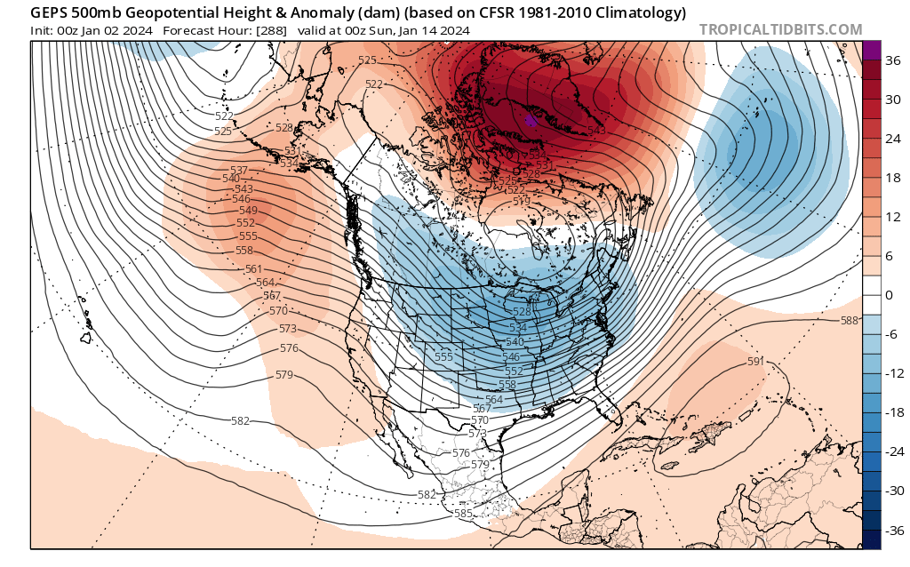
Since I'm here, I'm watching the 12Z GFS roll out.
Looks pretty similar to 6Z thus far. Primary is pushing into southern West Virginia which is starting to get a little close for the mix concerns. The timing of this transfer is relevant.
One of the big differences between the 12Z and previous runs is the energy in the Central US is digging further south and we're getting more northern stream interaction (CMC and GFS).
This is a fast-moving system so we won't have time to set up for something really big, but the dynamics will determine how potent a bomb we get for 8-12 hours.
It's good they are both there, because the 6Z Euro trended away from this sort of environmental interaction. Question is whether Euro follows.