

jwilson
-
Posts
1,146 -
Joined
-
Last visited
Content Type
Profiles
Blogs
Forums
American Weather
Media Demo
Store
Gallery
Posts posted by jwilson
-
-
GFS beat out both the Euro and Ukie on the last system. I'd be curious to know how often that happens (my guess is: not very). It was relatively accurate even six days out. Didn't waiver much, if at all.
Long range: I'm not sophisticated enough in this hobby to know all the details, but to me it appears one of the biggest issues is the MJO, which is more or less doing laps in the warm phases. Not that it's warm, mind you, but I would think these phases deter a -NAO establishing itself. Basically, a -NAO wants the warmer air over Greenland, while these MJO phases want the air over the CONUS. In other words, a +NAO and these MJO phases sync up. Again, pure speculation on my part because I don't know the extent of their interaction with one another. Perhaps it's the other way around.
I will say, the one positive appears to be the AO dropping off. Obviously, long-range determination hasn't been reliable this season, so that could end up either direction, but a -AO can definitely work in our favor. As long as the MJO isn't super amped, I'm not overly worried about it. The NAO just seems like it doesn't want to go negative and stay there lately, say within the last number of years. Constantly transient. I don't know why that is.
Getting excited about anything long-range this winter has been dangerous. As long as the moisture conveyor remains active, I think there will be chances, everything else just needs to align at once. We've certainly been close.
-
At least we got to wake up to some snow falling. No doubt this was a bit of a fail, but at least it wasn't all that surprising. Go with the model that gives us the worst result.
As for next week, the GFS says everything becomes northern stream dominant. I hope everyone likes cutters and clippers. The FV3, among others, is quite different.
Next Thursday is a weird result overall. Could be another rain to snow event. Following that we have a coastal chance on Monday. Need a NW trend.
-
25 minutes ago, blackngoldrules said:
I think we all pretty much knew throughout the week that this was inevitable. What got our hopes up was that damn Euro crushing us like it did for run after run. Hoped that the others would cave to it but the opposite happened. The Euro modeled this one very poorly this time around.
The GFS nailed this storm, basically since Monday. It didn't flip-flop once while the Euro went from north to south and then slowly back north again. I was worried the GFS was right because it was the most consistent. Certainly we didn't like what it showed, but it can score a coup every once in a while. Beating both the Euro and UK is an oddity, for sure.
-
4 minutes ago, north pgh said:
Nws getting bashed on Twitter. Not entirely their fault. I blame the local stations with all the hype. The closings, all the penndot stories, grocery stores cleaned out, hardware stores salt hype.
Sadly, the laymen among us don't really understand weather forecasting, so of course they are reactionary when things don't go as they expect. I also realize the NWS can't win. If they are wrong low or high, they are going to get bashed by people that don't understand meteorology.
That said, they should almost certainly know better than anyone as to our local climatology and model biases. Without a fresh cold airmass, that WAA is damn near impossible to stop. They seemed overzealous with the totals in the southern zones.
As for local news stations, unfortunately, not much you can do there. They are a business and in the business of ratings. It is quite literally their job to get viewers. Providing objective, factual information is a distant second. Showing Day 5+ model data to people who don't understand models is a terrible idea and always will be.
-
NWS updated map isn't all that different strangely. Feels like they didn't push snow totals north enough, unless they expect more on the back end of things.
-
2 minutes ago, MAG5035 said:
Well, did not like that final bump from the guidance this morning.. esp from the NAM. That's no bueno for the Pit Metro and our far southern tier gang. Everything's pretty much in agreement now and the surface low enters SW PA and runs southern PA instead of staying just south.. and that has the biggest implications in Pittsburgh and also south and east of H-burg with respect to higher snow totals. That track would also shift the deform snow axis NW to the northern tier and NW PA so the central locations are going to have to get there mostly on front end snow. That might spoil AOO and UNV's bid at 10 or more. But HRRR continues to look good for that general area you mention with those locations. I guess the good thing with that lousy track is that central is going to get slotted before it mixes for too long. If I were to make a call for the Harrisburg region, I think at least 4-5 is still pretty doable, and York/Lancaster region can still pick up 1-2".
Thanks for your analysis. In the PIT area, we weren't necessarily expecting to start as rain, but we already have rain and sleet observations in Allegheny county. Seems the north trend wins again, even late to the party, but we probably should have expected it without the necessary blocking and cold air in place. My temp (just south of the city) is already at 34F and precip hasn't started.
-
Second and final. I think this will be closer to correct, but I still wonder just how far north the rain line will get.
-
 1
1
-
-
Rain/snow line appears to be advancing rapidly north and east. It's already 33F here, so I don't hold out much hope for a front-end thump.
-
Even the short-range models can't agree. Honestly, we'll know soon enough. If the precip starts as rain, welcome to Bust City.
-
Even my conservative forecast might bust high, haha. Not surprising with no cold air locked into place.
Unfortunately, we can't get that broad trough storm we need. These storms demonstrate how rare the right track is for this area. Things almost always align too far north or too far south.
-
 1
1
-
-
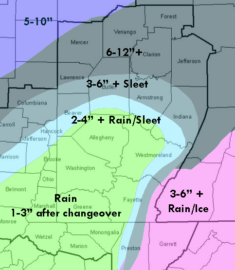
Here's a color map to go along with my prediction.
So the locations probably aren't perfect. Forgive my color scheme and photoshop skills (this was a quick job). It's more of a general idea. I'm mainly posting this to see how well I do versus the models and whether they are properly estimating the warmth, or if personal experience is the better rubric.
In terms of sleet: though I don't include measurements for it, there could be inches of sleet in those areas highlighted, obviously more as you go north in and around the city metro. Ice calls for the possibility of freezing rain. I don't imagine there will be significant accumulations of it, but a quarter inch+ in some localized cold spots isn't out of the question.
I do hope I bust low on these numbers, particularly south of the city, but I'd prefer to go conservative when there's a mixing possibility.
-
3
-
-
Update for next week's system:
I'm watching the 12Z GFS and notice a lot of energy hanging around at H5. Obviously, the initial wave is a cutter and does us no good, but after that we see a bit of packed dynamite hanging around in the south and down into Mexico. This is at hour 126, so it isn't fantasy range. The present evolution of this isn't useful for us, but what we could eventually get to is a classic Miller A if the NS drops in and phases. We'd have the 50/50 low and a high pressure to our north. Too early and west with the phase and that's bad (like the CMC shows), but if the low develops in the Gulf and pushes east, then phases, we have a pretty significant storm that would probably be decent for us. It goes without saying but it all depends on the location and timing.
Despite the rain storm ahead of time, there is a possible out to another good event next Thursday/Friday. I guess we'll see how it goes.
-
1
-
-
6 minutes ago, lpaschall said:
I dont trust anything the models put out outside of 36 hours. I have avoided our mid atlantic long range thread as its a roller coaster discussion that has zero usefulness.
I'm with you on that. The -NAO keeps getting pushed back (always two weeks away). The one positive sign is the -AO does look to come to fruition, but it could also immediately bounce back into positive territory, so all you can do is shrug your shoulders. The MJO isn't helping at all, doing laps in warm phases.
Long range forecasts have been extra unreliable this winter.
-
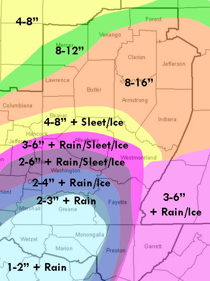
I forgot to mention there is a slight freezing rain hazard possible for places that change over to rain. If the surface doesn't warm as much as the 850s, which is possible if the primary low stays as far south as some models indicate, southern Allegheny into Washington and Greene counties could see a prolonged freezing rain event. Maybe .25-.50 which is a lot of freezing rain.
The 3K NAM does push surface temps up to 33-34 or so while the 850s stay below freezing, so that's more of a sleet/snow or even plain rain signal, but the opposite is still possible.
-
Yeah, despite the 0Z NAM shift from last night, I don't see enough change to make me feel all warm and tingly. I think this system is setting up for disappointment from city points south.
I'll say 2-5" (of snow) in the city and points south, with about 1-2" around the Mason Dixon line (mostly after temp crash). There will likely be an area that gets 2-4" of sleet or more on top of that snow, perhaps somewhere into Northern Allegheny just above the city into Westmoreland and Armstrong counties.
The jackpot zone will probably setup into Lawrence, Butler, and Clarion counties running northeast, and of course more as you get into central/northern PA.
Hopefully February brings more success. Of course, we get another cutter this week followed by a clipper parade.
-
1
-
-
The ICON didn't really change at all, but in fairness it's a lesser model. I don't know if it has any biases.
If the GFS and/or Euro look the same and don't follow the NAM, then it's a concern.
-
NAM verbatim looks like ~1 hour of sleet in extreme southern Allegheny, obviously longer points south, but otherwise is all snow.
It's still very close to too much WAA despite the primary shift from northern WV to southern. Talk about threading the needle.
-
NAM is almost a PA special. Anyone know if the models have ingested new data prior to the 0Z runs?
-
Hmm...
NAM could be a sampling issue, though I've noticed this "clipper" wave is coming in colder (maybe more south) than some of the models expected.
I won't get too excited until we see if the GFS, among others, follow suit, or if the NAM simply flips right back north at 6Z.
It led the way in 2016, so I won't totally discount it, either.
-
32 minutes ago, RitualOfTheTrout said:
Lol
I will say I expected more from this winter to this point. Still has time to redeemed itself and a favorable outcome this weekend would be a good start.
We're well below normal so far (if we finish that way, it would make 3 of the last 4 winters).
I agree that expectations for this winter were high. Things looked to align, but at this point, we're going to need a backloaded winter. The blocking that I think we require continues to be two weeks away in the long-term. Maybe by February it will actually coalesce. I'm hoping we don't revert to a bad pacific pattern or lose our moisture conveyor if the blocking comes together, but that's always possible.
-
2 hours ago, ChalkHillSnowNut said:
What about in Chalk Hill? I’m in the screw zone this time with maybe 2” with the warm tongue
I honestly don't know much about your area. Had to google the town. Are you near Uniontown? What's your local microclimate like?
It looks like you'd be in the ridges and susceptible to upsloping (orographic lift) thus more snow potential. If you get stuck in the warm sector like the rest of us south of Pittsburgh and west of the Apps, then you'll probably get no more than the city. Still waiting until 0Z, but right now even the meso models aren't promising. 3K NAM takes the line into Butler and almost north of Armstrong.
-
1
-
-
I'll make a guess after the "clipper" rolls through and the 0Z model runs, but I would think 3-6" for places between Washington and Pittsburgh is a fair call right now.
I'd still err on the side of lower figures, probably with either more rain or a couple inches of sleet cutting back snow amounts.
-
1
-
-
Always a bridesmaid ...

-
50 minutes ago, stjbeautifulday said:
Good morning! I’m totally a novice and enjoy reading here and getting excited with all of you! Trying to learn! What model does Al Roker use?! I don’t watch to get my local weather but thought it was interesting to see he only had the northern portions of New England getting big numbers. We weren’t getting much of anything based on his map.
Thanks for the banter! Love reading!
AFAIK, Al Roker isn't even a meteorologist. He has a B.A. in Communications. The people behind the scenes are probably using the GFS mostly, or some kind of blend.
Right now, though, most of the models aren't on our side if you're looking for heavy snowfall.
✨Pittsburgh PA ❄ Winter 2018-2019
in Upstate New York/Pennsylvania
Posted
Boy that 12Z Canadian run sure was fun. We get a triple phase on Monday that jumps from the benchmark to Utica, followed by a Miller A on Wednesday. That would basically be a dream week for us.
Of course, despite all that, we still only manage 10" in Allegheny.