StruThiO
-
Posts
82 -
Joined
-
Last visited
Content Type
Profiles
Blogs
Forums
American Weather
Media Demo
Store
Gallery
Everything posted by StruThiO
-
Oddball year with a springtime THC collapse
-
2022 Atlantic Hurricane season
StruThiO replied to StormchaserChuck!'s topic in Tropical Headquarters

-
2022 Atlantic Hurricane season
StruThiO replied to StormchaserChuck!'s topic in Tropical Headquarters
Lid's coming off -
2022 Atlantic Hurricane season
StruThiO replied to StormchaserChuck!'s topic in Tropical Headquarters
Yeah because we are in a strong El Nino just like 2009!!! Surely there hasn't been record strong Pacific trades, the lowest MEI ever observed except during the La Nina of 2010, historically low ONI etc etc etc etc etc......................... -
2022 Atlantic Hurricane season
StruThiO replied to StormchaserChuck!'s topic in Tropical Headquarters
Buy low; sell high. My $MDR calls about to print big boy bucks :] -
2022 Atlantic Hurricane season
StruThiO replied to StormchaserChuck!'s topic in Tropical Headquarters
k. meanwhile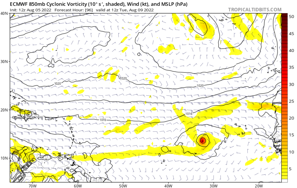
-
2022 Atlantic Hurricane season
StruThiO replied to StormchaserChuck!'s topic in Tropical Headquarters
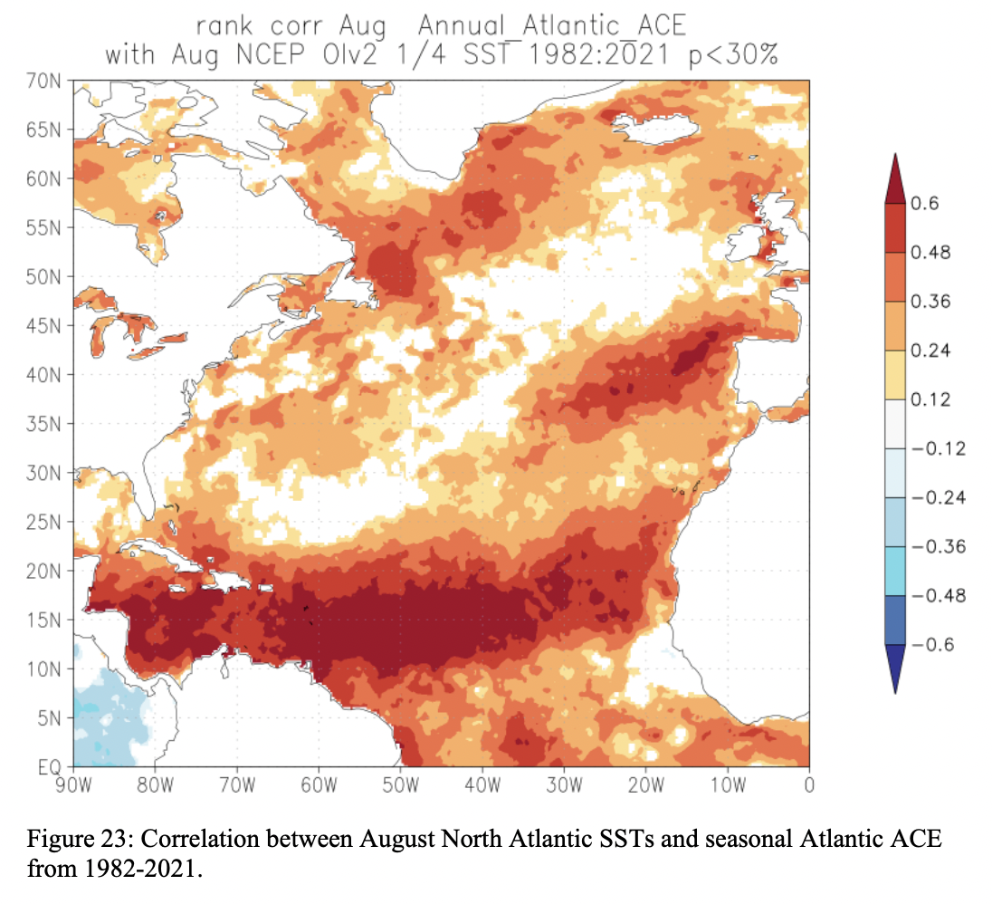
Eastern subtropics exhibits a positive correlation, in the domain of the AMO horseshoe. Western and central subtropics exhibits a far weaker correlation, so you can't group the entire subtropics as one whole like this.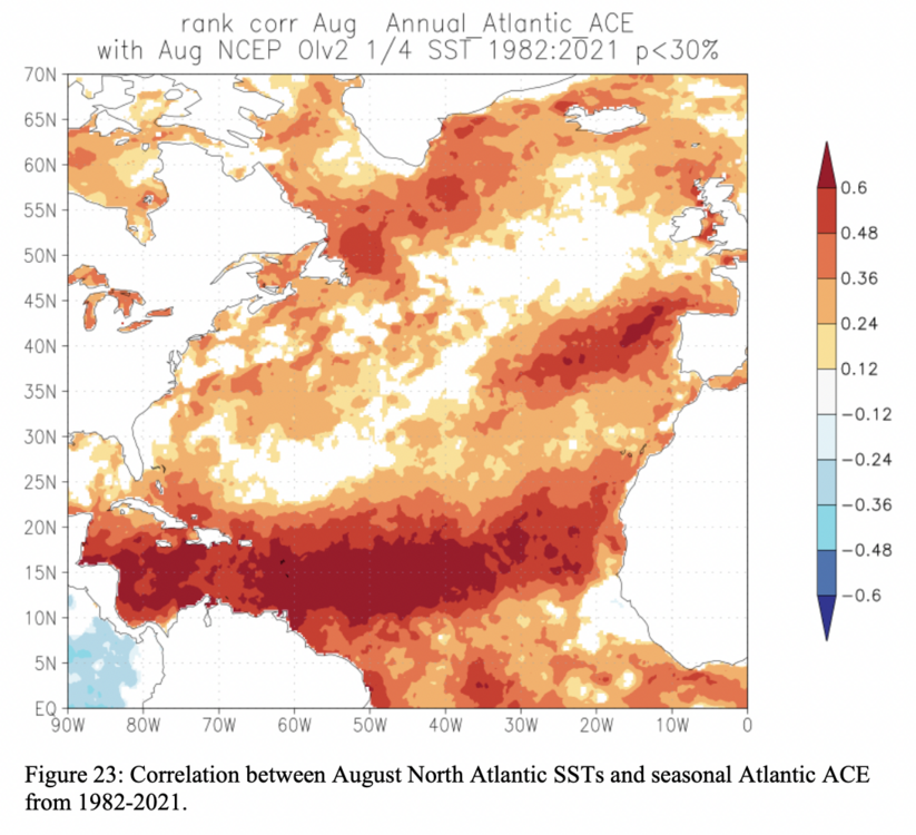
-
2022 Atlantic Hurricane season
StruThiO replied to StormchaserChuck!'s topic in Tropical Headquarters
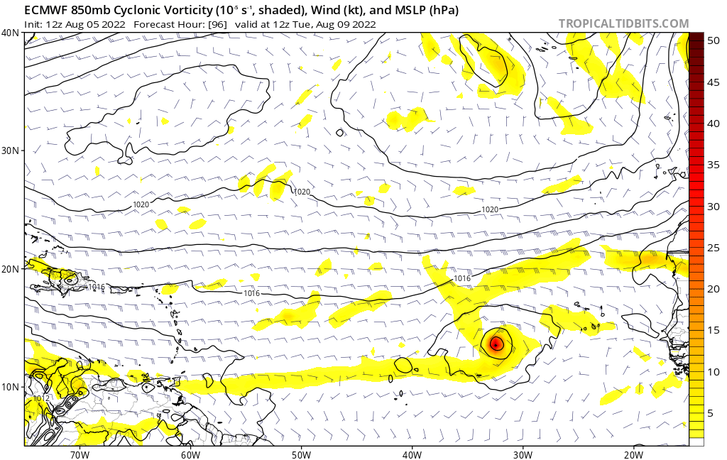
This feels like 2019, lol. MDR was a Sahara; comically dry from the Caribbean to Cape Verde, only through the C name and DEAD until late August.. but then what happened? Dorian happened. -
2022 Atlantic Hurricane season
StruThiO replied to StormchaserChuck!'s topic in Tropical Headquarters
At least he taught me a new word today - "vamoose" -
Agree; the modoki look will get shredded once this new upwelling KW propagates to the point of emergence. Will very much look classic again then until the transition away in Winter begins IMO
-
2022 Atlantic Hurricane season
StruThiO replied to StormchaserChuck!'s topic in Tropical Headquarters
frankly none of us fixate on operational GFS 300-h forecasts quite like this -
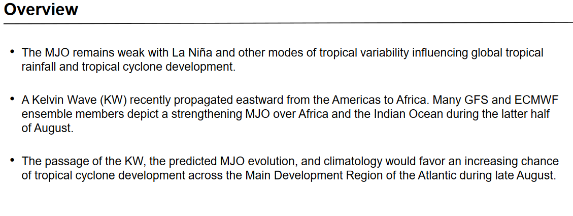
Trades are only going to continue to rip as the MJO circles back to p4/5..
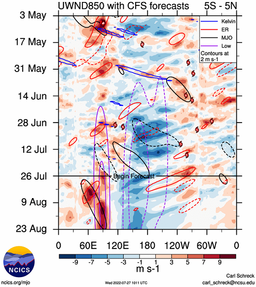
-
Don't really have words for what we are witnessing.. I don't think I've seen anything quite like this before..


-
The record-strong easterly wind stress has now resulted in the incredible initiation of an extremely potent upwelling Kelvin wave.
-
2022 Atlantic Hurricane season
StruThiO replied to StormchaserChuck!'s topic in Tropical Headquarters
It's July -
2022 Atlantic Hurricane season
StruThiO replied to StormchaserChuck!'s topic in Tropical Headquarters
Well, this does seems likely; after 3 years of La Nina it is likely to have exhausted itself and the El Nino response will probably initiate in Winter thru Spring 23 -
2022 Atlantic Hurricane season
StruThiO replied to StormchaserChuck!'s topic in Tropical Headquarters
It's July -
2022 Atlantic Hurricane season
StruThiO replied to StormchaserChuck!'s topic in Tropical Headquarters
Yeah surely 1080h will verify! 100% confidence -
2022 Atlantic Hurricane season
StruThiO replied to StormchaserChuck!'s topic in Tropical Headquarters
Totally normal. June + July combined don't even account for 10% of climatological hurricane activity. Here's a gif of monthly 500mb heights, long term mean, 1991-2020 climo. Observe the yearly maxima in ridging in July. This is why right now is the peak of Saharan dust season (and also season cancel season). It's also why August onwards constitute about 93% of climatological hurricane activity.
-
2022 Atlantic Hurricane season
StruThiO replied to StormchaserChuck!'s topic in Tropical Headquarters
Also, this is demonstrably incorrect. Thanks for playing, though!
-
2022 Atlantic Hurricane season
StruThiO replied to StormchaserChuck!'s topic in Tropical Headquarters
It's July It's July It's July It's July -
2022 Atlantic Hurricane season
StruThiO replied to StormchaserChuck!'s topic in Tropical Headquarters
It's July 17th. If you want to buckle down on what ECONUS mid-level flow will be like on August 17th from what it looks like today, least I remind folks that 2004 saw a very similar pattern in July during a -ENSO. Even our first major hurricane got hooked right into a strong mid-August trough. Then the pattern flipped and all hell broke loose. Interestingly, there was a pretty active June-July in the EPAC that year even with a -ENSO in place. Of course, again, it shut down and an epic WAR/AMO took over by August 31st. That does not mean we'll see a similar outcome, but clearly NINO 4 is bottoming out again and +PNA ridging may not last until the end of Summer. Minor correction but 2004 was an El Nino year. The import is still very true, as usual weenies gonna weenie -
2022 Atlantic Hurricane season
StruThiO replied to StormchaserChuck!'s topic in Tropical Headquarters
We will see hurricanes but probably not that 2017-esque. Also I wouldn't trust GFS as far as I can throw it -
2022 Atlantic Hurricane season
StruThiO replied to StormchaserChuck!'s topic in Tropical Headquarters
how can i get your weenie tag -
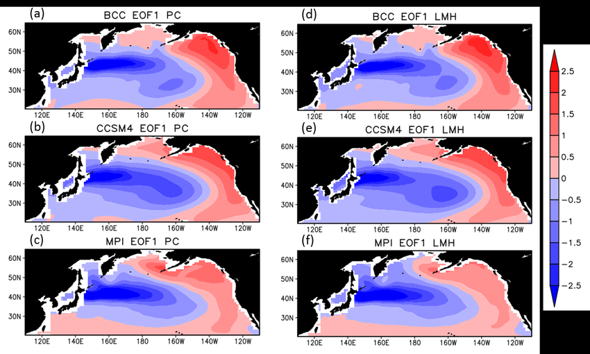
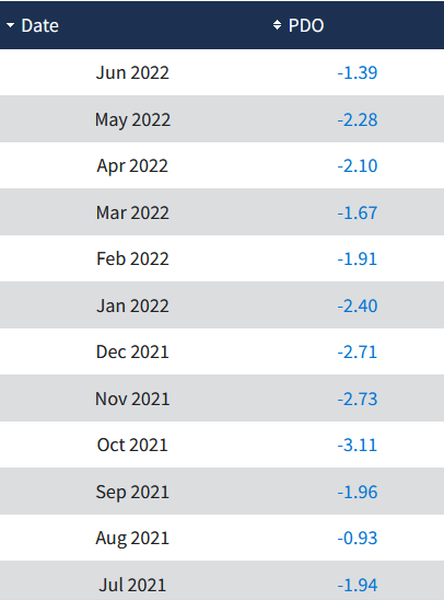
PDO is a regression of North Pacific SSTs. While the "horseshoe" region has warmed, the area extending east of Japan is still blazing hot and is anomalously warmer than the horseshoe. This still yields a net negative PDO, even after the recent warming. June will still be solidly negative although higher than this Spring. Definitely bullish on a flip to +PDO along with onset of El Nino.. finally.. around Spring 2023. The El Nino response to this will take time.. but I think could result in the strongest since 2015. Moderate to strong. We are due