

Saguaro
-
Posts
154 -
Joined
-
Last visited
Content Type
Profiles
Blogs
Forums
American Weather
Media Demo
Store
Gallery
Posts posted by Saguaro
-
-
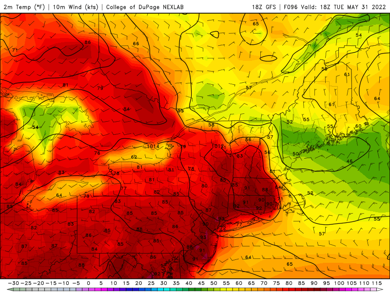
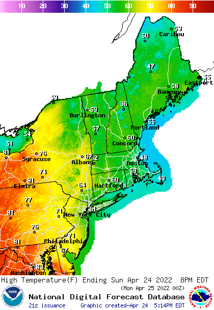
That is one brutal backdoor next week for ME and NH on the GFS. Completely snubs a potential four day heat event. I'll be heading back that way the second week of June so I've been keeping an eye on the pattern evolution.
-
2 hours ago, Typhoon Tip said:
But the former two are MCS tracking/favoring. They also would not likely allow uninterrupted heat- they both outright show a Tuesday am screen door slamming flag whipping backdoor blast. Whether that happens or not... that's what they are showing. Tuesday afternoon has most of eastern NE with temps down into the 50s before dark, and probably slate skies have slabbed in from the NE in those depictions/handling.
It's suspicious that immediately the following afternoon, it's rolled back out and flooded the region back close to 90. That's atypically too fast.
Yea, that's almost impossible to happen. The two most recent incursions this month show why. It's hard enough just getting a warm front to progress past the CT-Merrimack river valley areas, and even in the cases when said front has supposedly moved to northern ME/QC on WPC surface maps, there is this persistent, annoying tendency where the airmass is still contaminated to some degree, enough to significantly hinder max temps and dewpoints, along with any interesting convection.
-
 1
1
-
-
2 hours ago, Typhoon Tip said:
It just occurred to me… 20 years ago on this date in 2002 Worcester had an inch and a half of snow and we had cat paws in Waltham at 38° in a wind swept nor’easter…
Pretty sure that was 2002 and May 22… Or something like that
I remember that May was only second to May 2005 in terms of absolute misery in western ME. But later that summer was one for the ages. IZG notched an impressive 10 or 11 day streak of 90+ highs in August that year.
On 5/13/2022 at 4:47 AM, tamarack said:When CAR tied its record high of 96 on May 22, 1977, it was reported as the highest temp in the US that day. I don't know if that was actually the case, but if it was even close, "not often" would be a gross understatement.
Today turned out to be another such day, albeit a tie. IZG 93, out here in Phoenix area also 93.
2 hours ago, NW_of_GYX said:We had a cell move through Fryeburg and bridgton about 2 hours ago. Light rain and thunder.
It doesn't look like they ever included Cumberland in the watch area. Not sure if it was marine influence or other reasons, but the SVR stuff stayed well inland today.
-
Interesting. IZG looks to have finally overcome the marine air and managed a high of 93 so far. That's actually warmer than it is here in the Phoenix area so far today. Around 12:30, their wind finally switched to S and SW vs the SE, E, and NE it was all morning.
SPC issued watches and left out the fishtail of cumberland county, I guess that marine layer will still ruin storm chances again today.
-
 1
1
-
-
7 minutes ago, dendrite said:
Looks like still some weak E flow for much of ME/NH outside of the SW NH zones until late morning tomorrow.
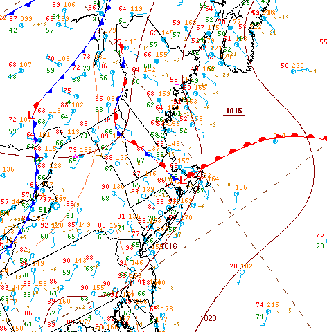
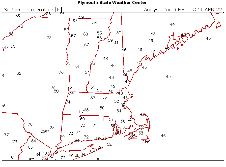
It was drawn on the surface analysis this afternoon, along with being mentioned briefly in some SPC discussions. It not only kept the heat out but kept the svr away. As others have mentioned, it backed in yesterday and for all intents and purposes was a backdoor.
17 minutes ago, dendrite said:You can see how the Euro (and other models) lost the high end heat for much of the area beginning 00z last night. Too much Atlantic taint.
Thursday evening the forecasts were for low to mid 90s today in Bridgton/Fryeburg area, but IZG was only able to muster 84.
-
5 hours ago, Typhoon Tip said:
I mean it's like an homage to hour special little meteorology here that WPC doesn't apparently know how to account for/ or is even aware.
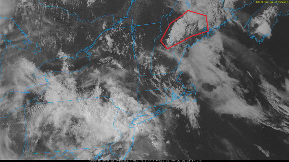
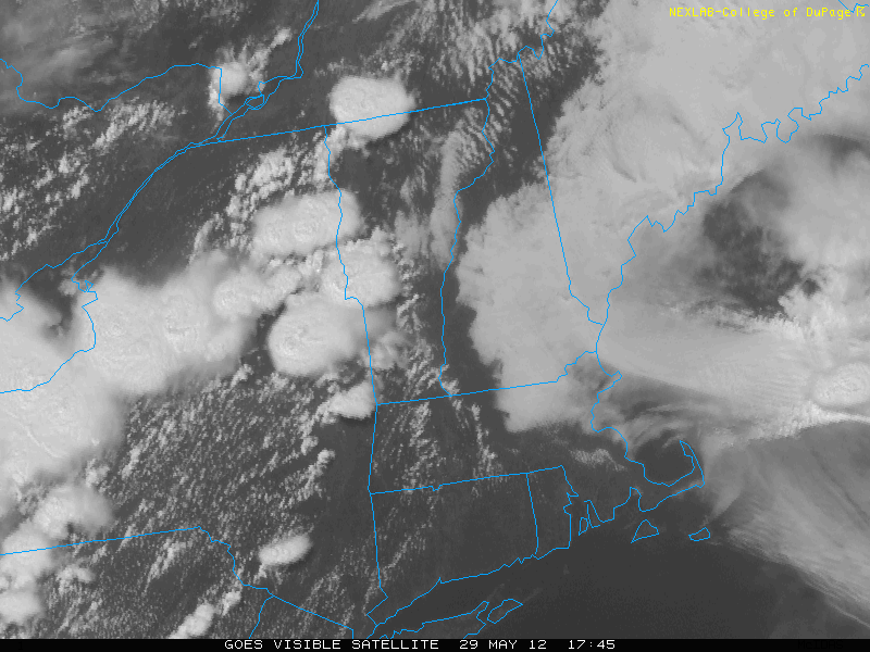
I mentioned this morning ... but that loop clearly smacked of a shallow/diffused BD having crept into eastern sections prior to dawn. FIT and ORH have been variable/averaging S/SW ....while BOS - BVY axis has been ENE all morning up under that latex paint.
It's breaking up now. Also, the SW motion from early wrt to the masses off the shore has also ceased and appears to be moving back N. Looks like it's washing out. Logan still E at 9mph though.
Definitely has that look on the visible. You can see that crap banking up against the spine of the apps in ME. There's even "reverse clearing" moving in from offshore. It's a day to drive rt 26 from Bethel to Errol and see the contrast.
Last weekend the same kind of thing happened with that backdoor dropping in and then slamming the door on any interesting convection the next couple days for eastern NNE as per the usual script.
-
11 hours ago, powderfreak said:
1.09” so far today, just emptied Stratus as inner tube was overflowing, 1.40” between yesterday evening and today.
Good solid soaker. The trees are going to go neon green after this.
66/64
I learned to never put much faith into dry patterns persisting into drought in NNE, there is always this kind of surprise soaker which will come along to halt them eventually.
It does appear there was a backdoor of sorts that dropped down from northern ME yesterday and, according to the maps, throughout the afternoon was snaking from just west of Montreal, winding through central VT/NH, and leaving just York county ME in the warm sector as it trailed off the coast. That cutoff circulation from last weekend did a full clockwise loop and went through ME today if the satellite was any indication.
10 hours ago, BrianW said:Those Midea units have absolutely stunning efficiency. Variable capacity inverter compressors are the future of heating and cooling. America is stupidly slow to adapt to the technology. 90% of Asia and Europe have been using inverter driven compressors for the last decade.
My mini split is rated at an insane 38 seer. Nearly 4 times the efficiency of a whole house ac or window unit.
It can move heat in the summer at a COP (coefficient of performance) of 8.79. Thats an effective thermodynamic efficiency 879%.
In the winter I can heat my house when its 5 degrees out at twice the efficiency of any fossil fuel source of heat.
Add in some solar and your fuel is essentially free.

LG makes inverter window units as well but they have the traditional design and aren't U shaped. They are much quieter for sure. I had one during the tail end of my time in ME. Hopefully one day someone will be able to make 6k BTU inverter window units.
The mini-split units are great, unfortunately the prices to get them installed in the US are ridiculous when you compare to Europe and Asia. I got a multi-head Mitsubishi put in last year before prices went completely insane. One in the garage and one in the bedroom with option to add a third down the road. It saves more to use than the central, plus it's nice to have a backup in case the central goes out, summer in AZ doesn't joke around.
17 hours ago, dendrite said:I remember that day well. Back then I lived in a small town called Ridgefield just south of Danbury in CT. The previous evening I had TWC on and they were tracking it getting started in the great lakes and going through Ontario. Then it turned into a monster once it got into NY state, flattening thousands of trees in the Adirondacks. It made me pull an all nighter thinking it would be a historic event once it reached my area. In actuality it was a dud by that time, a threatening looking sky, few drops of rain and gusts of wind. Then it cleared on out like a Texas dry line storm and the ensuing day was one for the ages.
That was the infamous DXR hits 103 day, and during my time in CT I never remembered any other summer afternoon which felt as hot as that one did, and even if we may not have hit 103 we were easily near 100. The dewpoints didn't mix out despite the heat. Looking at the archived surface maps from back then, it appears that derecho coaxed a backdoor looking boundary to move south and west, maybe earlier than forecast. The following day was noticeably cooler and drier.
-
1
-
-
High ended up being 84 here in the Phoenix area today. IZG/Fryeburg hit 85. Not often that happens. Tomorrow onwards the heat is returning here, back to the 90s then 100-105 into next week.
-
6 hours ago, tamarack said:
You need to think of midsummer when it's 96/76 on the Boston Common and 72 (both air and water) at your place, with a nice sea breeze.

Had 73/30 yesterday. This morning's low of 37 ends a six-day run of sub-freezing minima.
Forecast contrast not often seen: Maine foothills, sunny and 85. Inland SNJ, sunny and 69. Only in late spring NNE.IZG got up to 85, and Montreal hit 90. It's currently 80 here around 2pm so those may eclipse the Phoenix area today.
-
15 hours ago, tamarack said:
Good conditions to translate that to 2m warmth, too - low dews, early August sun angle, trees <5% leaf-out (a guess for Thurs-Fri; <1% currently). That last has 2 effects, very little transpirational moisture to be heated and sun beating on the leaf litter to add warmth from below. We hit 89 on 5/2/2001 (with zero leaf-out, as pack lasted thru 4/23); can we sniff 90 next week?
I still remember how warm it got in March 2012, well into the 80s if I remember right. It was full dead winter landscape and foliage which made it look unsettling. Oddly enough, a similar situation happens out here where we have our best chance to get the highest heat before the solstice. At that point, the westerlies have moved far enough north that we start getting moisture incursion from the gulf of Baja California and even the Gulf of Mexico depending on the pattern. With that comes the monsoon months of July, August, and September.
The GFS runs since yesterday have unfortunately been cutting down those 850 temps in ME. It even shows a backdoor hitting on saturday now, and after that the ridge looks to get gutted by the remains of that stubborn cutoff associated with the terrible conditions in SNE today. Seems the ECMWF is showing much of the same.
-
4 hours ago, powderfreak said:
Crazy 10 day QPF. Not sure I remember ever seeing zilch for entire states like VT/NH on 10-day QPF map.

Wow that looks like 10-day QPF maps here most of the time. The last time I can remember a rain-free stretch that long in Maine was the omega block "high over low" situation that lasted a good chunk of April back in 2013. Near the end of it, with all the dirt roads around dust clouds were being kicked up like the Dukes of Hazzard. Certainly not the typical April expectation, it was a welcomed respite.
I can say that the heat which is building out here this go around is the highest of the season thus far. We've hit 97 today and expecting the first 100 of the year tomorrow. GFS 850 temps over ME next week show some rare 18-19Cs. Tough to get those into ME even in summer.-
1
-
-
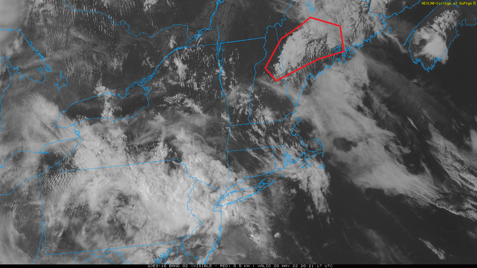
1 minute ago, STILL N OF PIKE said:
That map will posted is great . 45 in Bos 50 in Tolland and 80 in Ithica
here's another
-
55 minutes ago, HIPPYVALLEY said:
I really miss that PDfamily wx site and their mesomap.
Yea I don't know what happened to it. One day the data just quit working and it never got fixed after that.
One thing that still takes a bit to get used to here vs NE is how low the dewpoints can crash after a frontal passage. The other day when the ridge that had us in the 90s for a few days began migrating to the east coast, we had a frontal passage that took the dewpoint from low 40s to 5 below zero. It was startling how cold it felt, even though it was in the upper 60s, it was light jacket weather. I always figured that once you hit the 30s in dewpoints it was diminishing returns for how it affected the perception of warmth.
-
1
-
-
8 hours ago, dendrite said:

Pushing 90F in NE NJ

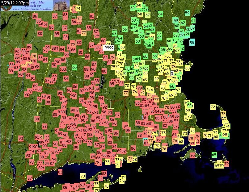
Yeesh. Horror show. So many times this kind of thing happened in the springs and well into the summers too when I lived in ME. Here's memorabilia from another one circa May 2012.
-
3
-
-
The ridge that will eventually (hopefully?) be migrating out that way is establishing itself over us at the moment. Today's high was right around 90. We had our first 90s of the season about a week and a half ago. Rest of this week:
Wednesday: Sunny, with a high near 93. North wind 5 to 10 mph becoming east in the morning. Winds could gust as high as 20 mph.
Wednesday Night: Clear, with a low around 64. Breezy, with a northeast wind 5 to 15 mph, with gusts as high as 25 mph.
Thursday: Sunny, with a high near 94. Northeast wind 5 to 10 mph.
Thursday Night: Clear, with a low around 63. Northeast wind around 5 mph.
Friday: Sunny, with a high near 97. East northeast wind around 5 mph.
Friday Night: Mostly clear, with a low around 65. Calm wind becoming east northeast around 5 mph after midnight.
Saturday: Mostly sunny, with a high near 97. East wind 5 to 10 mph becoming west southwest in the afternoon.On Sunday it starts moving out of here. Next week will be much cooler with 70s.
On 4/4/2022 at 2:53 PM, Typhoon Tip said:Yeah... who was I mentioning this too - can't remember. But there's probably like 1::12 or 1::9 type of return rate on median passable Aprils, otherwise, the more common rendition falls beneath whatever 'median' is in this context - so some subjectivity to that. I don't think 3 days nicking 70, while the other 20 some odd days are < 60 ... ass loads of cold rain... NE wind days ... putrid car top slush, saves any face for example.
I've just been wilted too many times. I'm not going to stick the flower of optimism out there ever again for this piece of shit climate anus that seems to shit in your bed in direct deliberate proportion to said optimism. Like I said last page or two ago, you count on the BDF screwing it up, whether it is on the model or not, in a scenario like that next week. Then, it's a daily elimination game to remove having one occur, day by day.
You really have the best way of wording the unique experience of eastern new england's climate. I say that as someone who endured the same misery there for many, many failed springs and summers. I watched that same elimination game carry well into summer, and forecasted heat waves get continually trimmed back on both the front and backside until, as mentioned it was basically a transient warm sector for 24-48 hours.
On 4/4/2022 at 2:56 PM, Typhoon Tip said:Having said that... May 2005 is still the worst month that has ever happened in the space-time continuum existence of this planet. Ironically... no April has ever been that bad.
I remember there being a particularly miserably, cold, rainy period in mid to late May 2002 before the pattern suddenly and dramatically reversed in early June, going on to be a summer for the ages. It wasn't as bad as that 2005 stretch but it was memorable. Maybe more so in Maine than the rest of NE.
On 4/4/2022 at 6:19 PM, eekuasepinniW said:peepers on 4/4 wtf

I heard them out in southwest CT back in mid March when talking to a friend of mine who lives there.
-
10 minutes ago, dryslot said:
If that's the case, That would be 2hrs sooner then forecast, NWS had them flipping by 03z.
It's showing 33.8 for temp so I don't think it's sticking yet. Last four updates showing -SN
https://mesowest.utah.edu/cgi-bin/droman/meso_base_dyn.cgi?stn=KIZG&unit=0&timetype=LOCAL
-
IZG has gone over to snow now
-
I've been checking IZG obs and they're still raining. I think they're getting close though, dewpoint has been dropping and the temp is now down to 35. I thought lowering ceilings might offer a clue but they've been bouncing around. GYX forecast is 12-18"
-
1
-
-
Still -4, actually dropped to -5 for a bit within the last hour.
-
1
-
-
-4 currently in the western Maine Bridgton area. Will be going from this to mid 70s in AZ tomorrow.
-
3
-
 1
1
-
-
Sleet and freezing rain have commenced in the Bridgton ME area. Temps in the lower 20s.
-
Yesterday's event in the Bridgton ME area began as a burst of snow that amounted to a heavy coating, followed by freezing rain for a few hours. Little to no icing. It doesn't appear there was any additional snow overnight. Tomorrow's event looks well south and minimal impact this far north.
-
I've been back in Maine for Christmastime. This was a very rare year where there wasn't a grinch storm for Christmas. Instead there was a snow event on Christmas day as well as a few minor events in the preceding week. It does seem very difficult to keep rain at bay for the Christmas to New Year stretch, and sure enough there were some rain events the week after Christmas as well as New Years day. In the meantime, back in AZ the same time period had a very gloomy, chilly and damp stretch which rivaled the typical late May pattern in Maine. The Phoenix area even got down near freezing last weekend.
Today's event has begun as snow with those anomalously large flakes that warn of warming in the upper levels and imply an imminent switch to sleet and freezing rain. Heading back to AZ tomorrow, where the pattern has greatly improved to clear skies with highs in the lower 70s. Someone at the NWS there sounds like springtime powderfreak, focusing on the large diurnal spreads:
Quote`Quiet` best summarizes our weather for the next few days. 12Z
Sounding data from across the west reveals a strong jet streak at
500mb entering OR and N CA. Arizona and SoCal will sit to the
south of this feature, beneath the influence of flat ridging and
surface high pressure. Light boundary layer winds, dry air, and
clear skies are allowing for pretty substantial diurnal
temperature swings - as much as 35 to 40 degrees across rural
deserts.According to the NBM, the chance of reaching 70F at Sky Harbor
climb from nil on Wednesday to 60% Friday afternoon. However, this
guidance (specifically for PHX) is about 2F too cool as of this
writing, and was biased a bit cool yesterday as well. A little
over-performance won`t surprise me too much the next couple
afternoons. Bottom line, expect to need that jacket in the
mornings, and maybe a pair of shorts by mid-afternoon!14 hours ago, ORH_wxman said:Jan 2019 was pretty impressive. ORH had a high of 1F. Had to go back to 1994 to get that. Even Jan 2004 didn’t beat that.
I've never seen anything which has topped that Jan 1994 arctic outbreak. We had a solid week of single digit highs in southwest CT at the time, while I believe the Burlington VT area couldn't get above zero for that duration.
-
6 hours ago, Saguaro said:
These past three days, IZG has been warmer than the Phoenix AZ area:
10/12
KIZG: 78
KFFZ: 68
10/13
KIZG: 81
KFFZ: 74
10/14 so far
KIZG: 78
KFFZ: 72Today's highs ended up being:
KIZG: 79KFFZ: 77
Tomorrow's forecast calls for mid 80s at FFZ and mid 60s at IZG, so this stretch looks like it's over.


May 2022 Thread
in New England
Posted
That's an apt analogy. It's certainly been a persistent trend on the models for a few days now. Knowing how these go, it would not surprise me to see SPC throw an enhanced or moderate risk right up to the edge of the summer side of it for a day or two next week while the other side rots away in the clammy gloom. GYX says the culprit is stubborn troughing in the maritimes running up against a block and retrograding. I've certainly seen the trend in the past where these end up barreling down to Philly or DC when initially they're forecast to halt in CNE. If that happens, ME and NH may at least get some sun out of it.
We each have our own preferences, but I'd much prefer sun and heat with convection potential to low ceiling 40s on the eve of met summer.