

Saguaro
-
Posts
154 -
Joined
-
Last visited
About Saguaro

-
Impressive that IZG managed 100 with dewpoints staying close to 70. The July 2011 event it mixed down to the 50s (maybe even 40s?). Over here in FFZ we've so far managed 100.9 according to the mesowest, so it looks like a tie with IZG, except dewpoints are much lower (upper 20s). Our P&C next 7 days has 102/106/107/108/112/113/112 so I doubt IZG will tie again anytime soon.
-
Yep, looks legit: 14:54 100.0 14:50 100.4 14:45 100.4 14:40 98.6 14:35 100.4 14:30 98.6
-
IZG managed 100.4 at 14:35
-
IZG stuck at 98-99, doesn't seem like 100 is in the cards today
-
IZG stuck at 98.6 the past hour. Seeing lots of little clouds popping up on satellite so that might be a factor.
-
IZG 97 already wow 8am: 88 9am: 91 10am: 93 They could legitimately be warmer than here today, our forecast high is 102. The temps/dews across NE yesterday and today match up with typical July monsoon airmasses here.
-
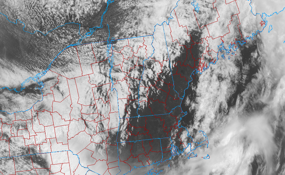
Interesting cloud behavior on satellite. They seem to be holding stationary to the north and west of the major mountain divides. BTV and BML say 2600ish ceilings. IZG despite the early clearing still only managing 84 at this hour.
-
It's definitely a notable heat dome. Yesterday's late afternoon high was 115, which is about the hottest I've experienced since living here the past four years. It has begun its departure east so we're cooling off today (109) going into next week as temps fall back to the lower 100s.
-
Abundance of sun here as well, managed a late afternoon high of 102 today off a low of ~72. Our warmest of the year thus far. Currently sitting at 100/21, dewpoints have been in the upper teens and low 20s all day. Looks downright miserable back in the coastal plain of NNE, I certainly don't miss these late May/June debacles.
-
Yea it still hasn't gotten started here yet. We've had a couple days of 100+ and then it's being knocked down to the 80s and lower 90s for several days. Last week we even had multiple mostly overcast days. This upcoming week it looks like we might get our warmest days of the year Wednesday through Friday with highs topping out around 104, but cooling down again after with another trough approaching.
-
Was that July 2011? Or was there another event in 2010, I can't remember very well. I wonder if WPC will ever put a dryline on the current sfc obs map in NE during these occurrences, since a couple months ago I remember there being a similar situation with a severe outbreak in Illinois, and they actually drew a dryline on the map in that one. It wasn't the usual desert origin dry air which is why I found it unusual.
-
May 2024 Discussion - Welcome to Severe Season!!!!
Saguaro replied to weatherwiz's topic in New England
Managed 93.2 this afternoon, slighty above IZG. It has been a cool year so far, first 90s were delayed to mid April (usually happens around the equinox), and just a couple days ago it finally hit 100 for the first time. -
May 2024 Discussion - Welcome to Severe Season!!!!
Saguaro replied to weatherwiz's topic in New England
Going to be close. We're in a cooler pattern the last few days, IZG hit 91.9 and our current high 91.4. I just thought the NNE heat was impressive for this time of year. -
May 2024 Discussion - Welcome to Severe Season!!!!
Saguaro replied to weatherwiz's topic in New England
IZG at 91, warmer than Phoenix metro currently (~89 here). -
Looks like most of Maine held off the gloom but it creeped into western ME towards late afternoon. There have been a copious amount of clouds here in AZ today as well, but still managed a high of 90. This is definitely the time of year when being in AZ vs the coastal plain of NNE pays handsomely.


