KeefRichards
-
Posts
9 -
Joined
-
Last visited
About KeefRichards

-

Western PA/Pittsburgh Fall Weather Discussion
KeefRichards replied to Ahoff's topic in Upstate New York/Pennsylvania
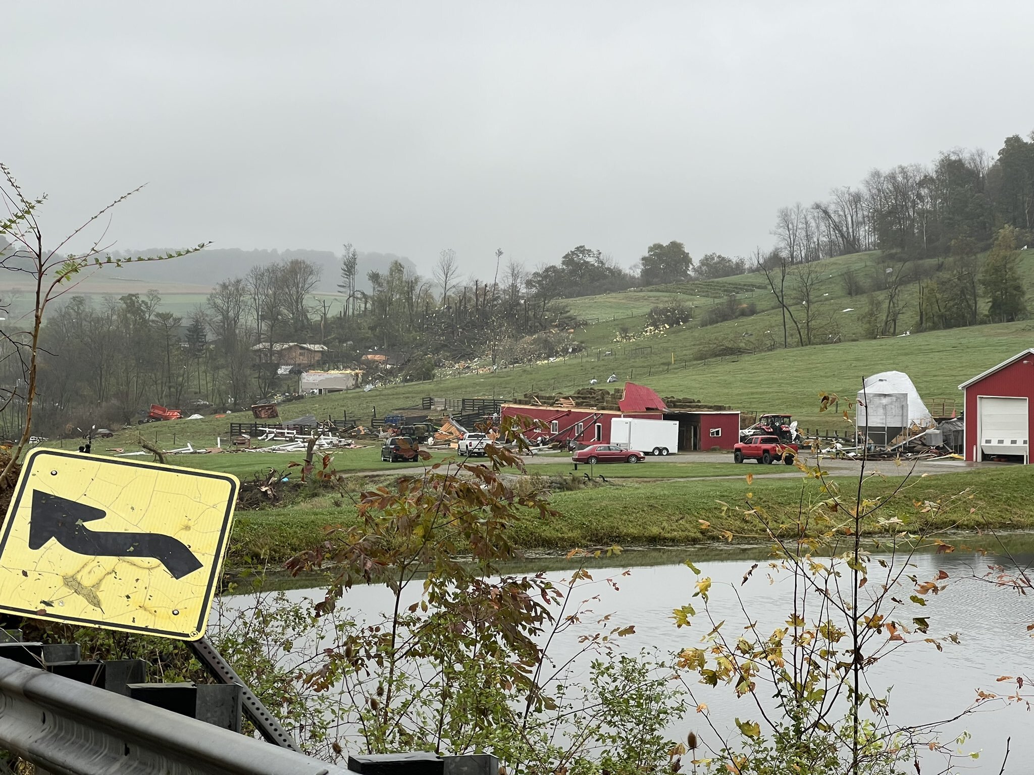
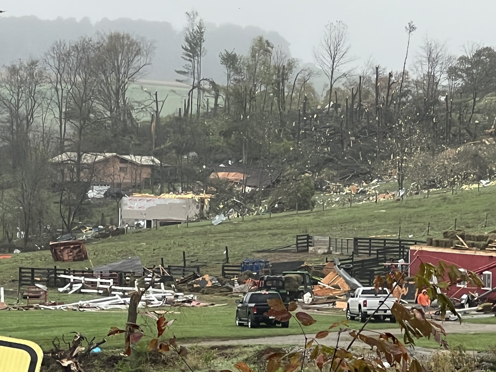
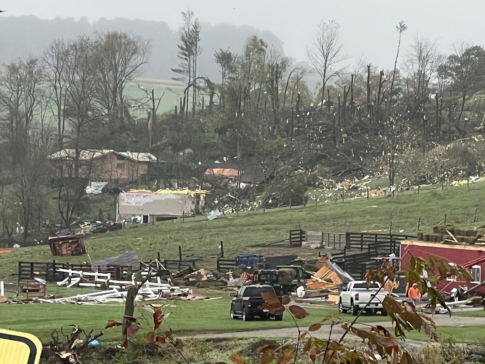
Willow Rd & Lowry Lane, Hopewell Twp, Washington, Co.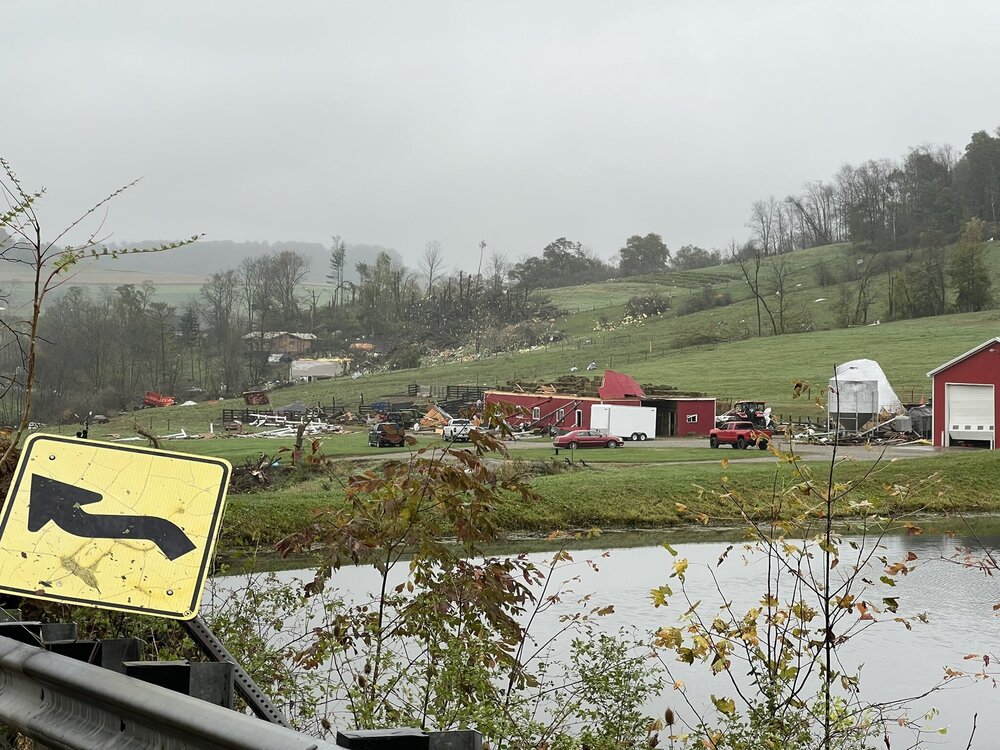
-
Western PA/Pittsburgh Summer Discussion 2021
KeefRichards replied to Ahoff's topic in Upstate New York/Pennsylvania
Up to 1.95" on the day in N Strabane. Looking where this deform band is setting up & what has already fallen, I'm not getting a good feeling about the next 24 hours. -
Notorious cold spot, KAFJ sitting at -3 currently.
-
Moved into my current house in the Summer of 2017. This is by far the greatest snow depth I have seen here. Perhaps more to come as well.
-
000 NOUS41 KPBZ 091421 PNSPBZ OHZ039>041-048>050-057>059-068-069-PAZ007>009-013>016- 020>023-029-031-073>076-WVZ001>004-012-021-509>514-100221- Public Information Statement Spotter Reports National Weather Service Pittsburgh PA 921 AM EST Tue Feb 09 2021 The following are unofficial observations taken during the past 3 hours for the storm that has been affecting our region. Appreciation is extended to highway departments, cooperative observers, Skywarn spotters and media for these reports. This summary also is available on our home page at weather.gov/pittsburgh ********************STORM TOTAL SNOWFALL******************** LOCATION TOTAL TIME/DATE COMMENTS SNOWFALL MEASURED (inches) OHIO ...Belmont County... 1 W Powhatan Point 7.0 831 AM 2/09 Public 1 E Morristown 6.0 725 AM 2/09 Dept of Highways 2 SE St. Clairsville 5.8 830 AM 2/09 Public ...Columbiana County... 2 WSW Lisbon 9.0 728 AM 2/09 Dept of Highways ...Guernsey County... 1 S Quaker City 7.0 650 AM 2/09 Public Cambridge 6.5 905 AM 2/09 Twitter 5 W Cambridge 6.0 708 AM 2/09 Trained Spotter ...Harrison County... 1 W Piedmont 6.0 700 AM 2/09 Trained Spotter ...Jefferson County... Rayland 5.5 849 AM 2/09 Twitter 2 NNW Wintersville 3.2 729 AM 2/09 Dept of Highways ...Monroe County... Woodsfield 8.0 800 AM 2/09 Broadcast Media ...Muskingum County... 5 N Zanesville 6.0 834 AM 2/09 Twitter Zanesville 5.5 634 AM 2/09 From WHIZ ...Tuscarawas County... Newport 2.6 815 AM 2/09 Public 3 WSW New Philadelph 2.0 729 AM 2/09 Dept of Highways 4 S New Philadelphia 1.7 820 AM 2/09 Public PENNSYLVANIA ...Allegheny County... Penn Hills 6.6 741 AM 2/09 Public South Side Flats 6.1 800 AM 2/09 Public McKeesport 6.0 819 AM 2/09 Trained Spotter 2 E Imperial 5.6 850 AM 2/09 Trained Spotter Shadyside 5.1 850 AM 2/09 Facebook S Carrick 5.0 850 AM 2/09 Public Oakdale 4.9 710 AM 2/09 Twitter Imperial 4.9 844 AM 2/09 Twitter Springdale 4.8 821 AM 2/09 Trained Spotter West View 4.7 810 AM 2/09 Trained Spotter SE Natrona Heights 4.5 630 AM 2/09 Public 1 E Sharpsburg 4.5 630 AM 2/09 Public 1 NE Churchill 4.5 800 AM 2/09 Public Upper Saint Clair 4.5 733 AM 2/09 Facebook Ross Township 4.5 830 AM 2/09 Facebook Brentwood 4.5 852 AM 2/09 Twitter S Natrona Heights 4.4 850 AM 2/09 Trained Spotter 2 E Elizabeth 4.1 700 AM 2/09 Public Castle Shannon 4.0 719 AM 2/09 Trained Spotter 1 N Carnot-Moon 4.0 649 AM 2/09 Storm Total as of 7am 2 SE Penn Hills 4.0 720 AM 2/09 Trained Spotter Berkeley Hills 4.0 730 AM 2/09 Broadcast Media SW Castle Shannon 4.0 856 AM 2/09 Trained Spotter Jefferson Hills 3.9 800 AM 2/09 Trained Spotter Moon 3.8 840 AM 2/09 Trained Spotter South Park Township 3.8 650 AM 2/09 Facebook 2 W Moon 3.5 720 AM 2/09 Public ...Beaver County... Ohioville 1.7 903 AM 2/09 Twitter North Sewickley 1.0 630 AM 2/09 Public ...Butler County... N Cranberry 1.8 820 AM 2/09 Public ...Clarion County... Clarion 0.6 840 AM 2/09 Public ...Fayette County... Perryopolis 3.0 853 AM 2/09 Trained Spotter ...Indiana County... Homer City 4.0 855 AM 2/09 Facebook 1 N Homer City 3.5 800 AM 2/09 Public ...Mercer County... 1 S Fredonia 0.3 845 AM 2/09 Public SE Mercer T 805 AM 2/09 Trained Spotter ...Washington County... McDonald 5.2 900 AM 2/09 Trained Spotter Washington 4.5 637 AM 2/09 Trained Spotter McMurray 4.2 800 AM 2/09 Facebook 1 NW Finleyville 4.0 700 AM 2/09 Public California 3.4 715 AM 2/09 Trained Spotter ...Westmoreland County... Greensburg 6.0 746 AM 2/09 Trained Spotter 1 W New Kensington 4.5 700 AM 2/09 Trained Spotter 1 NW Beatty 4.0 800 AM 2/09 Public 1 SW Georges Station 3.5 805 AM 2/09 Public WEST VIRGINIA ...Hancock County... Weirton 4.1 700 AM 2/09 Public ...Marshall County... McMechen 5.8 800 AM 2/09 Facebook ...Ohio County... Wheeling 5.0 639 AM 2/09 From WTRF
-
Just measured 5" here during the last hurrah.
-
Feel sorry for those that still have to commute on days like today. The whole COVID work from home model in my case has really allowed me to enjoy this winter like no other. Love snow, but hate commuting to work in it.
-
Rip roaring here in northern Washington Co. too. Gotta get some sleep for work tomorrow, this is going to be tough.
-
Here's the top 10 from KPBZ: https://www.weather.gov/media/pbz/records/snow.pdf 82.0 1950-1951 78.5 1913-1914 77.4 2009-2010 76.8 1993-1994 76.0 1960-1961 74.5 1995-1996 72.1 1992-1993 70.7 1969-61970 63.6 1935-1936 63.4 2013-2014